Choctawhatchee Bay

Choctawhatchee Bay is a bay in the Emerald Coast region of the Florida Panhandle. The bay, located within Okaloosa and Walton counties, has a surface area of 129 mi2 (334 km2).[1] It is an inlet of the Gulf of Mexico, connected to it through East Pass (also known as Destin Pass). It also connects to Santa Rosa Sound in Fort Walton Beach, Florida to the west and to St. Andrews Bay in Bay County to the east, via the Gulf Intracoastal Waterway. East Pass is the only outlet of the bay flowing directly into the Gulf of Mexico.[2] The Choctawhatchee River flows into it, as do several smaller rivers and streams.[1][3] The Mid-Bay Bridge crosses the bay, connecting the city of Destin to Niceville, Florida.
History
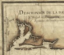
The bay was charted by Spanish, French, and English expeditions, and appears on some charts as "St. Rose's Bay".[4][5]
Several towns and cities are located on Choctawhatchee Bay:
References
- 1 2 "GulfBase - Choctawhatchee Bay". Retrieved 2007-11-25.
- ↑ "EAST PASS INLET MANAGEMENT STUDY IMPLEMENTATION PLAN CERTIFICATE OF ADOPTION" (PDF). Florida Department of Environmental Protection. Retrieved 2007-11-26.
- ↑ "Choctawhatchee Info - HISTORICAL". Retrieved 2007-11-25.
- ↑ John D. Ware (1982). George Gauld, Surveyor and Cartographer of the Gulf Coast. Gainesville: University Press of Florida.
- ↑ "The Coast of West Florida and Louisiana. Jefferys, Thomas, 1775". The David Rumsey Collection. Retrieved 2007-11-26.
Coordinates: 30°26′22″N 86°18′40″W / 30.43944°N 86.31111°W