Chocorua, New Hampshire
| Chocorua, New Hampshire | |
|---|---|
| Unincorporated community | |
|
A small dam on the Chocorua River in the village of Chocorua | |
 Chocorua  Chocorua | |
| Coordinates: 43°52′39″N 71°13′13″W / 43.87750°N 71.22028°WCoordinates: 43°52′39″N 71°13′13″W / 43.87750°N 71.22028°W | |
| Country | United States |
| State | New Hampshire |
| County | Carroll |
| Town | Tamworth |
| Elevation | 525 ft (160 m) |
| Time zone | Eastern (EST) (UTC-5) |
| • Summer (DST) | EDT (UTC-4) |
| ZIP code | 03817 |
| Area code(s) | 603 |
| GNIS feature ID | 871674[1] |

Chocorua is an unincorporated community within the town of Tamworth in Carroll County, New Hampshire, United States. It is located in the general area where Routes 16 and 113 meet, south of Mount Chocorua and Chocorua Lake.
Mount Chocorua is commonly known in the area as the "Matterhorn" of the White Mountains due to its triangular summit. Chocorua Lake at the southern base of the mountain is among the most beautiful lakes in the White Mountains. Tourists often pull off Route 16 and stop to swim and take pictures of the lake with the mountain in the background.
Notable people
- Truman Howe Bartlett, sculptor, Abraham Lincoln photography historian (summer resident)
- William James, philosopher and US founder of experimental psychology; died in Chocorua[2]
- Paul Scott Mowrer, New Hampshire's first Poet Laureate; lived in Chocorua[3]
- Hadley Richardson, the first wife of Ernest Hemingway.[3]
- Robert I. Rotberg, former President of the World Peace Foundation (vacation resident)
References
- ↑ "Chocorua". Geographic Names Information System. United States Geological Survey.
- ↑ "William James", Stanford Encyclopedia of Philosophy
- 1 2 Hemingway, Jack. Misadventures of a Fly Fisherman, pp. 269-70
External links
Municipalities and communities of Carroll County, New Hampshire, United States | ||
|---|---|---|
| Towns | 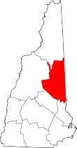 | |
| Township | ||
| CDPs | ||
| Other villages | ||
This article is issued from Wikipedia - version of the 10/17/2016. The text is available under the Creative Commons Attribution/Share Alike but additional terms may apply for the media files.