Cho La, Nepal
| Cho La | |
|---|---|
|
Cho La, panoramic view to the east | |
| Elevation | 5,420 m (17,782 ft) |
| Location | Solukhumbu District, Nepal |
| Range | Himalayas |
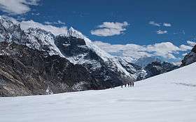
Cho La is a summit pass located 5,420 metres (17,782 ft) above sea level in the Solukhumbu District in northeastern Nepal. It connects the village of Dzongla (4,830 metres (15,850 ft)) to the east and the village of Thagnak (4,700 metres (15,400 ft)) to the west.
Tourism
The pass is on Gokyo trail, one of the popular and challenging trekking trails in Khumbu Everest region. To the west the trail continues to Gokyo Lakes crossing Ngozumpa glacier on the way. To the east the trail joins the Everest Base Camp trek.[1]
The pass can be physically demanding and may require crampons on top of a slippery glacier. The edge of the glacier is unstable.[1]
References
External links
This article is issued from Wikipedia - version of the 8/29/2015. The text is available under the Creative Commons Attribution/Share Alike but additional terms may apply for the media files.