Chirripó National Park
| Chirripó National Park | |
|---|---|
|
IUCN category II (national park) | |
 | |
| Location | Costa Rica |
| Nearest city | San Isidro del General |
| Coordinates | 9°28′48″N 83°28′48″W / 9.48000°N 83.48000°WCoordinates: 9°28′48″N 83°28′48″W / 9.48000°N 83.48000°W |
| Area | 50,849 hectares (125,650 acres) |
| Established | August 19, 1975[1] |
| Governing body | National System of Conservation Areas (SINAC) |
Chirripó National Park is a national park of Costa Rica, encompassing parts of three provinces: San José, Limón and Cartago. It was established in 1975.[1]
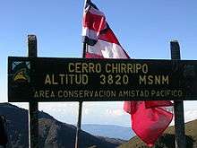
It is named for its most prominent feature, Cerro Chirripó, which at 3,820 metres (12,530 ft) is the highest mountain in Costa Rica.[2]
Geography

Chirripó is the 38th most prominent peak in the world. In terms of Holdridge life zones, the park can be categorized into five ecosystems:[3] lowland tropical wet forest, premontane tropical wet forest, lower montane wet forest, montane wet forest and subalpine wet forest (páramo). Most of the park consists of both primary rain forests and primary cloud forests. Around 9,000 ft (2,740 m) it changes to wet desert. [4]
Summiting the peak begins with a hike along a 16.5-kilometre (10.3 mi) uphill trail from the town of San Gerardo de Rivas to the park ranger's refuge in the Los Crestones sector; that is followed by a 5-kilometre (3.1 mi) walk to the peak.
Climate
The climate is dominated by two seasons: a dry season lasting from December to April and a wet season from May to November,[5]
During the dry season the upper regions are susceptible to fires. The latest recorded events have occurred in 1953, 1958, 1976, 1977, 1981 and 1992. This last event, however, affected over 20 square kilometres (7.7 sq mi) of vegetation and forced the administration to close the park for four months.[1]
The park is one of the coldest places in Costa Rica. In fact, the coldest temperature - 15°F (-9°C) - ever recorded in Costa Rica was recorded here. [6]
Las Nubes

The Las Nubes Centre for Neotropical Conservation and Research is a facility located at the southwest corner of the park and managed by York University of Toronto through an agreement with Costa Rica's Tropical Science Center.[7]
References
- 1 2 3 "Parque Nacional Chirripo" (in Spanish). SINAC (Sistema Nacional de Areas de Conservacion). Archived from < the original on 2007-05-03. Retrieved 2013-01-07.
- ↑ McNeil, Jean (2002). The Rough Guide to Costa Rica. p. 53. ISBN 1-85828-713-8.
- ↑ Holdridge, L.R., Grenke, W.C., Hatheway, W.H., Liang, T & Tosi, J.A. 1971. Forest Environments in Tropical Life Zones: a Pilot Study. Oxford, Pergamon Press
- ↑ Stater, Adam. "Geography in Chirripo National Park".
- ↑ Lindsey, Alton A. & Sawyer, John O. (1971). Vegetation of the life zones in Costa Rica, Indiana Academy of Science, p. 214
- ↑ http://www.anywherecostarica.com/attractions/national-park/chirripo
- ↑ "Creation of Las Nubes". Las Nubes Project. Retrieved 2013-01-07.
External links
- Chirripó National Park at Costa Rica National Parks