Chine

A chine (pronunciation: /ˈtʃaɪn/) is a steep-sided river valley where the river flows to the sea through, typically, soft eroding coastal cliffs of sandstone or clays. The word is still in use in central Southern England—notably in East Devon, Dorset, Hampshire and the Isle of Wight—to describe such topographical features. However, 'bunny' is also used to describe a chine in Hampshire, as noted below.
Formation and features
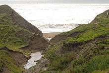
Chines appear at the outlet of small river valleys when a particular combination of geology, stream volume and coastal recession rate creates a knickpoint, usually starting at a waterfall at the cliff edge, that initiates rapid erosion and deepening of the stream bed into a gully leading down to the sea.[1]
All chines are in a state of constant change due to erosion. The Blackgang Chine on the Isle of Wight, for example, has been destroyed by landslides and coastal erosion during the 20th century. As the walls of the chines and cliffs are so unstable and erode continually, particularly those of the south coast of the Isle of Wight, the strata are clearly visible. Chines are, therefore, very important for their fossil records, their archaeology and the unique flora and fauna, such as invertebrates and rare insects, for which they provide shelter.[2]
On the southern coast of the mainland of England
In Devon, Sherbrooke Chine is west of Budleigh Salterton,[3] and Seaton Chine is at the western end of the West Walk esplanade, Seaton. In Dorset, west of Bournemouth are found Flaghead Chine, Branksome Chine, Alum Chine, Middle Chine and Durley Chine, and east towards Boscombe, Honeycombe Chine. Becton Bunny and Chewton Bunny are other examples of chines near Barton on Sea, Hampshire ("Bunny" being the New Forest term equivalent to "Chine").[4][5]
A rare example of the use of 'Chine' in a non-coastal setting is Chineham, a civil parish near Basingstoke.
Isle of Wight
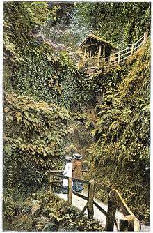
There are twenty chines on the Isle of Wight, to which fascinating folklore is attached because of their history with local smuggling, fishing and shipwrecks. The popular tourist attraction of Shanklin Chine is also famous for its involvement in the Second World War, when it was used to carry one of the Operation Pluto pipelines and as training area for the 40 Royal Marine Commando battalion before the 1942 Dieppe Raid.[6]
Geologically, the chines in Alum Bay, in Totland (Widdick Chine), and the three in Colwell Bay (Colwell Chine, Brambles Chine and Linstone Chine) are in Tertiary rocks. The remainder on the island's south coast are in Cretaceous rocks.
An inventory of chines on the Isle of Wight follows, listing chines clockwise from Cowes:[2]
- Shanklin Chine
- Luccombe Chine
- Blackgang Chine
- New Chine
- Walpen Chine or Old Walpen Chine
- Ladder Chine
- Whale Chine
- Shepherd's Chine
- Cowleaze Chine
- Barnes Chine
- Grange/Marsh Chine
- Chilton Chine
- Brook Chine
- Churchill Chine
- Shippards Chine
- Compton Chine
- Alum Bay Chine
- Widdick Chine
- Colwell Chine
- Brambles Chine
- Linstone Chine
References
- ↑ Chines on the Isle of Wight: Channel Adjustment and Basin Morphology in Relation to Cliff Retreat, Katharine E. Flint, The Geographical Journal, Vol. 148, No. 2 (Jul., 1982), pp. 225-236
- 1 2 Modelling flow, erosion and long-term evolution of incising channels: managing hydrology and geomorphology for ecology, Norton, Leyland & Darby, Sediment Dynamics and the Hydromorphology of Fluvial Systems, International Association of Hydrological Sciences, 2006, ISBN 1-901502-68-6 Google Books, retrieved 3 August 2008
- ↑ Complete England, Reginald JW Hammond, Ward Lock, 1974
- ↑ West, Ian. 2008. Barton and Highcliffe - Coast Erosion and Sea Defences: Geology of the Wessex Coast of southern England. Internet site: Version: 25 July 2008.
- ↑ Chewton Bunny, Old Hampshire Gazetteer
- ↑ Isle of Wight, Gem of the Solent, June Elford, Coach House Publications, 2004, ISBN 1-899392-33-5 Google Books, retrieved 5 July 2008