China Strait
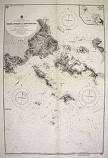
World War II-era United States Navy map of the China Strait.
The China Strait is a navigable strait in the Milne Bay Province of Papua New Guinea between Samarai Island and Sariba Island. The strait, 4 nautical miles (7 km) in length and .75 nautical miles (1 km) wide, connects the Solomon Sea with the Coral Sea.
References
- "CIA World Factbook". Retrieved 2006-05-25.
- ITouch Map of the China Strait
- Pacific Wrecks (1997–2009). "Samarai Island". Milne Bay Province, Papua New Guinea. Pacific Wrecks.org. Retrieved April 28, 2009.
This article is issued from Wikipedia - version of the 9/5/2014. The text is available under the Creative Commons Attribution/Share Alike but additional terms may apply for the media files.