Chikugo Province
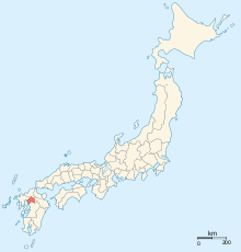
Chikugo Province (筑後国 Chikugo no kuni) is the name of a former province of Japan in the area that is today the southern part of Fukuoka Prefecture on Kyūshū.[1] It was sometimes called Chikushū (筑州), with Chikuzen Province. Chikugo was bordered by Hizen, Chikuzen, Bungo, and Higo Provinces.
History
The ancient capital of the province was located near the modern city of Kurume, Fukuoka.
In the Edo Period the province was divided into two fiefs: the Tachibana clan held a southern fief at Yanagawa, and the Arima clan held a northern fief at Kurume.
In the Meiji period, the provinces of Japan were converted into prefectures. Maps of Japan and Chikugo Province were reformed in the 1870s.[2]
Timeline of notable events
- 1359 (Enbun 4): Battle of Chikugo River (Chikugogawa), Ashikaga gain a military victory.[3]
- 1361 (Enbun 6) : Imperial forces led by Kikuchi Takemitsu capture Dazaifu.[4]
Shrines and temples

Kōra taisha was the chief Shinto shrine (ichinomiya) of Chikugo. [5]
Historical districts
- Fukuoka Prefecture
- Ikuha District (生葉郡) - merged with Takeno District to become Ukiha District (浮羽郡) on February 26, 1896
- Kamitsuma District (上妻郡) - merged with Shimotsuma District to become Yame District (八女郡) on February 26, 1896
- Mihara District (御原郡) - merged with former Mii (御井郡) and Yamamoto Districts to become a new and expanded Mii District (三井郡) on February 26, 1896
- Mii District (pre-1896) (御井郡) - absorbed Mihara and Yamamoto Districts to become a new and expanded Mii District (三井郡) on February 26, 1896
- Miike District (三池郡) - dissolved
- Mizuma District (三潴郡)
- Shimotsuma District (下妻郡) - merged with Kamitsuma District to become Yame District on February 26, 1896
- Takeno District (竹野郡) - merged with Ikuha District to become Ukiha District on February 26, 1896
- Yamamoto District (山本郡) - merged with former Mii (御井郡) and Mihara Districts to become a new and expanded Mii District (三井郡) on February 26, 1896
- Yamato District (山門郡) - dissolved
See also
Notes
- ↑ Nussbaum, Louis-Frédéric. (2005). "Chikugo" in Japan Encyclopedia, p. 113, p. 113, at Google Books.
- ↑ Nussbaum, "Provinces and prefectures" at p. 780.
- ↑ Tsuji, Zennosuke. (1932). The Humanitarian Ideas of the Japanese, p. 55; Depuy, Trevor Nevitt. (1992). "Kikuchi Takemitsu," The Harper Encyclopedia of Military Biography p. 402.
- ↑ Nussbaum, Louis-Frédéric. (2005). "Kikuchi Takemitsu" in Japan encyclopedia, p. 517.
- ↑ "Nationwide List of Ichinomiya," p. 3 Archived May 17, 2013, at the Wayback Machine.; retrieved 2012-10-26.
References
- Nussbaum, Louis-Frédéric and Käthe Roth. (2005). Japan encyclopedia. Cambridge: Harvard University Press. ISBN 978-0-674-01753-5; OCLC 58053128
External links
![]() Media related to Chikugo Province at Wikimedia Commons
Media related to Chikugo Province at Wikimedia Commons