Johnson South Reef
| Disputed island Other names: Chigua Reef, Yongshu reef, Gạc Ma Reef, Mabini reef | |
|---|---|
 | |
| Geography | |
 | |
| Location | South China Sea |
| Coordinates | 9°42′54″N 114°17′13″E / 9.715°N 114.287°ECoordinates: 9°42′54″N 114°17′13″E / 9.715°N 114.287°E |
| Archipelago | Spratly Islands |
| Administered by | |
| People's Republic of China | |
| Claimed by | |
| People's Republic of China | |
| Vietnam | |
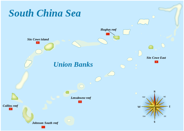
Johnson South Reef (Chinese: 赤瓜礁; pinyin: Chìguā Jiāo; Vietnamese: Đá Gạc Ma), also known as Chigua Reef in China, Gạc Ma Reef in Vietnam and Mabini reef in Philippines[1][2] is a reef in the southwest portion of Union Banks, in the Spratly Islands of the South China Sea. It is controlled by the People's Republic of China (PRC), but its ownership is disputed by the Philippines, Brunei, Taiwan, and Vietnam.
Location, topography and structures
Johnson South Reef lies adjacent to the Vietnamese-controlled Collins Reef (also known as Johnson North Reef) which lies 6.4 kilometres (4.0 mi) to the northwest. It is naturally above water only at low tide. It houses a number of small buildings, wharves and a fortified Chinese maritime observation station.[3]
On 12 July 2016, the tribunal of the Permanent Court of Arbitration concluded that Johnson Reef contains, within the meaning of Article 121(1) of the Convention, naturally formed areas of land, surrounded by water, which are above water at high tide. However, for purposes of Article 121(3) of the Convention, the high-tide features at Johnson Reef is rocks that cannot sustain human habitation or economic life of their own and accordingly shall have no exclusive economic zone or continental shelf. [1]
Territorial disputes
Johnson South Reef is currently occupied by the People's Republic of China and claimed by Vietnam. It was the site of the 1988 Johnson South Reef Skirmish between the PRC and Vietnam that resulted in the death of 64 Vietnamese soldiers,[4] two Vietnamese boats being sunk and the Chinese occupying the reef.
In order to prevent the reef from submersion caused by erosion, and to maintain the claim to the EEZ, the PRC government built an embankment building, and Johnson South Reef surrounded the building in the early 1990s.[5]
In July 2012, to further reinforce their claim, a Chinese fleet of 29 fishing vessels from Hainan protected by Yuzheng 310 (a fishery administration patrol ship) spent 20 days fishing in the region.[6]
During 2014, Chinese reclamation work expanded the usable surface area to 11 hectares, accommodating what appears to be a military and radar base and a small harbour.[7] As of May 2016, the Chinese reclaimed 109,000 square meters (10.9 ha) of land.[7]
See also
References
- 1 2 "Award" (PDF). Permanent Court of Arbitration. 12 July 2016. p.121
- ↑ Malig, Jojo (17 July 2012). "Chinese fleet eyes bumper harvest". ABS CBN News. Retrieved 29 October 2013.
- ↑ "China fishing fleet arrives in Spratlys". Philippine Inquirer - Global nation. 17 July 2012. Retrieved 29 October 2013.
- ↑ "Vietnamese activists remember 1988 Spratly Islands clash with China". Deutsche Welle. Retrieved 16 March 2016.
- ↑ Johnson South Reef / Chigua Reef (中国南沙群島赤瓜礁図片]), www.nansha.org.cn
- ↑ "30-vessel China fishing fleet arrives at Nansha Islands". Xinhua English - Sina English News. 15 July 2012. Retrieved 29 October 2013.
- 1 2 "Johnson reef tracker". Center for Strategic and International Studies. Retrieved 2016-03-05.
External links
- Our World Flashpoint: South China Sea, BBC, film documentary, July 2015.
| Related articles | |||||||||||||||||||
|---|---|---|---|---|---|---|---|---|---|---|---|---|---|---|---|---|---|---|---|
| Confrontations | |||||||||||||||||||
| Military occupations | |||||||||||||||||||