Chiayi County
| Chiayi County 嘉義縣 | |||
|---|---|---|---|
| County | |||
 | |||
| |||
 | |||
| Coordinates: 23°29′46.34″N 120°38′30.75″E / 23.4962056°N 120.6418750°ECoordinates: 23°29′46.34″N 120°38′30.75″E / 23.4962056°N 120.6418750°E | |||
| Country | Taiwan | ||
| Region | Southwestern Taiwan | ||
| Seat | Taibao City | ||
| Largest city | Minxiong | ||
| Boroughs | 2 cities, 16 (2 urban, 14 rural) townships | ||
| Government | |||
| • County Magistrate | Helen Chang (DPP) | ||
| Area | |||
| • Total | 1,901.67 km2 (734.24 sq mi) | ||
| Area rank | 10 of 22 | ||
| Population (December 2014) | |||
| • Total | 524,783[1] | ||
| • Rank | 14 of 22 | ||
| Time zone | National Standard Time (UTC+8) | ||
| Website | www.cyhg.gov.tw | ||


| Chiayi County | |||||||||||||||
| Traditional Chinese | 嘉義縣 | ||||||||||||||
|---|---|---|---|---|---|---|---|---|---|---|---|---|---|---|---|
| |||||||||||||||
Chiayi County (Chinese: 嘉義縣; pinyin: Jiāyì Xiàn) is a county in southwestern Taiwan surrounding but not including Chiayi City. It is the sixth largest county in Taiwan.
Name
The former Chinese placename was Tsu-lo-san[2] (Chinese: 諸羅山; pinyin: Zhūluóshān; Pe̍h-ōe-jī: Chu-lô-san), a representation of the original Formosan-language name Tirosen. A shortened version, Tsulo, was then used to name Tsulo County, which originally covered the underdeveloped northern two-thirds of the island. In 1704, the county seat was moved to Tsulosan, the site of modern-day Chiayi City. Following the 1723 Zhu Yigui rebellion, the county was reduced in size. In 1787, the county and city were renamed Kagee (嘉義; literally: "commended righteousness") to acknowledge the citizens' loyalty during the Lin Shuangwen rebellion.
History
Empire of Japan
During the Japanese rule of Taiwan, the area of Tainan Prefecture covered modern-day Chiayi County, Chiayi City, Tainan and Yunlin County.
Republic of China
After the handover of Taiwan from Japan to the Republic of China on 25 October 1945, the area of present-day Chiayi County was administered under Tainan County. In October 1950, Taiwan Provincial Government formed the Chiayi County Government and Chiayi County was established as a county of Taiwan Province in the same month. Chiayi City was subsequently downgraded from a provincial city and designed as the county seat of Chiayi County.[3]
In December 1978, the Executive Yuan approved the upgrade of Chiayi City to become a provincial city, thus in December 1981, Chiayi County government relocated the county capital to Dongshiliao Farm in Taibao Township and Chiayi City finally became a provincial city in July 1982.
In March 1989, Wufong Township was renamed to Alishan Township and in July 1991, Taibao Township was restructured to become Taibao City. In November 1991, Chiayi County government relocated the county capital from Dongshiliao Farm to Hsiangho New Village in Taibao City.[4] Puzi Township was restructured to a county-controlled city in September 1992.
Geography
Chiayi County is bordered with Mount Yu to the east, Taiwan Strait to the west, Tainan City to the south and Yunlin County to the north. It spans over 1,903 km2, about 5.35% of Taiwan area. Due to its location along the Tropic of Cancer path, Chiayi County has a unique landscape with other regions in Taiwan.[5]
Administration

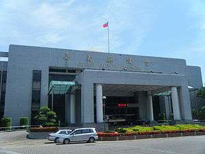
Chiayi County is divided into 2 cities, 2 urban townships, 13 rural townships and 1 mountain indigenous township. Taibao City is the seat of Chiayi County and is home to Chiayi County Government. The Chiayi County Council is however located in Puzi City. Helen Chang of the Democratic Progressive Party is the incumbent Magistrate of Chiayi County.
| Name (Hanyu Pinyin) | Hanzi | Wade-Giles | Tongyong Pinyin | Taiwanese (POJ) | Hakka Pha̍k-fa-sṳ |
|---|---|---|---|---|---|
| City | |||||
| Taibao City | 太保市 | T'ai-pao | Taibao | Thài-pó | Thai-pó |
| Puzi City | 朴子市 | P'u-tzu | Puzih | Phò-chú | Phú-chṳ́ |
| Urban townships | |||||
| Budai Township | 布袋鎮 | Pu-tai | Budai | Pò͘-tē | Pu-thoi |
| Dalin Township | 大林鎮 | Ta-lin | Dalin | Tōa-nâ | Thai-lìm |
| Rural townships | |||||
| Dapu Township | 大埔鄉 | Ta-p'u | Dapu | Tōa-po͘ | Thai-phû |
| Dongshi Township | 東石鄉 | Tung-shih | Dongshih | Tang-chio̍h | Tûng-sa̍k |
| Fanlu Township | 番路鄉 | Fan-lu | Fanlu | Hoan-lō͘ | Fân-lu |
| Liujiao Township | 六腳鄉 | Liu-chiao | Liujiao | La̍k-kha | Liuk-kiok |
| Lucao Township | 鹿草鄉 | Lu-ts'ao | Lucao | Lok-chháu | Lu̍k-tshó |
| Meishan Township | 梅山鄉 | Mei-shan | Meishan | Bôe-san | Mòi-sân |
| Minxiong Township | 民雄鄉 | Min-hsiung | Minsyong | Bîn-hiông | Mìn-hiùng |
| Shuishang Township | 水上鄉 | Shui-shang | Shueishang | Chhúi-siāng | Súi-song |
| Xikou Township | 溪口鄉 | Hsi-k'ou | Sikou | Khe-kháu | Hâi-khiéu |
| Xingang Township | 新港鄉 | Hsin-Kang | Singang | Sin-káng | Sîn-kóng |
| Yizhu Township | 義竹鄉 | I-chu | Yijhu | Gī-tek | Ngi-tsuk |
| Zhongpu Township | 中埔鄉 | Chung-p'u | Jhongpu | Tiong-po͘ | Chûng-phû |
| Zhuqi Township | 竹崎鄉 | Chu-Ch'i | Jhuci | Tek-kiā | Tsuk-khì |
| Mountain indigenous townships | |||||
| Alishan Township | 阿里山鄉 | A-li-shan | Alishan | A-lí-san | Â-lî-sân |
Demographics
| Historical population | ||
|---|---|---|
| Year | Pop. | ±% |
| 1985 | 569,932 | — |
| 1990 | 552,277 | −3.1% |
| 1995 | 565,804 | +2.4% |
| 2000 | 562,305 | −0.6% |
| 2005 | 553,841 | −1.5% |
| 2010 | 543,248 | −1.9% |
| 2015 | 519,839 | −4.3% |
| Source:"Populations by city and country in Taiwan". Ministry of the Interior Population Census. | ||
The current population of Chiayi County as of December 2014 is 524,783 people. The county has been experiencing a population decline since 2009 due to higher migration out of the county and higher death rate than birth rate.[1] In 2013, the birthrate in the county was 5.89, lower than the average Taiwan of 8.91, the second lowest after Keelung.[6]
Education

Chiayi County is home to the government-owned National Chung Cheng University and National Chiayi University. Private universities and colleges including Chang Gung University of Science and Technology, Nanhua University, Toko University and WuFeng University. Education-related affairs in the county is managed by the Educational Department of Chiayi County Government.
Economy
Over the past 20 years, Chiayi County had often been left out in the regional economic development due to its less strategic location, lack of infrastructure and appropriate industrial land to attract manufacturers to set up factories in the area. All of the existing industrial parks in the county were built before 1981. Class 2 and class 3 industries have been developing slowly throughout Chiayi, thus the economic development is sluggish as well, resulting in slow urban development.
Three industrial parks named the Dapumei Industrial Park (大埔美工業區), Ma Chou Hou Industrial Park (馬稠後工業區) and Budai Intelligent Industrial Park are currently under planning in the county.[6][7] Industrial parks in the neighboring counties and cities also contributed to the difficulty of industrial developments in Chiayi County.
Energy
The Zengwen Hydroelectric Plant and Chiahui Gas-Fired Power Plant boasted the total national grid capacity of 50 MW and 670 MW respectively. Both of the power plants are located in the county.
Tourist attractions

Museums
Notable museums and monuments in Chiayi County are the National Radio Museum, Ping Huang Coffee Museum, Southern Branch of the National Palace Museum and Tropic of Cancer Monument.
Natural
Bordered by mountains on one side and sea on the other side, Chiayi County holds three major national parks, which are Alishan National Scenic Area, Southwest Coast National Scenic Area and Siraya National Scenic Area, each represents a unique view of nature's wonders, from mountains, plains to ocean views.[8] It also houses the Haomeiliao Wetland.
Dams
The county also has the following dams, which are Renyitan Dam and Zengwen Dam.
Buildings
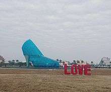
The county houses the Dongshi Fisherman's Wharf and High-Heel Wedding Church.
Transportation

Air
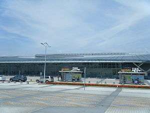
Chiayi County is served by Chiayi Airport located at Shuishang Township, Taibao City and neighboring Chiayi City.
Rail
The Taiwan High Speed Rail destination to Chiayi County stops at Chiayi Station in Taibao City. Taiwan Railways Administration stations include the Dalin Station, Minxiong Station, Nanjing Station and Shuishang Station. The county also houses the Alishan Forest Railway leading to Alishan National Scenic Area.
Relative location
 |
|
| ||
| Taiwan Strait (South China Sea) Fujian, |
|
| ||
| ||||
| | ||||
| |
See also
| Wikimedia Commons has media related to Chiayi County. |
References
- 1 2 "Welcome to Chiayi County Government-Population-Population". cyhg.gov.tw.
- ↑ Campbell, William (1903). "Explanatory Notes". Formosa under the Dutch: described from contemporary records, with explanatory notes and a bibliography of the island. London: Kegan Paul. p. 549. OCLC 644323041.
- ↑ "Welcome to Chiayi County Government-History-Republic of China Era (1945-)". cyhg.gov.tw. Archived from the original on 2014-03-28.
- ↑ "Welcome to Chiayi County Government-History-Republic of China Era (1945-)". Cyhg.gov.tw. Archived from the original on 2014-03-28. Retrieved 2014-05-04.
- ↑ "Welcome to Chiayi County Government-Geography-Geography". cyhg.gov.tw.
- 1 2 "Chiayi's low birthrate is problem for education". taipeitimes.com.
- ↑ http://invest.cyhg.gov.tw/english/CP.aspx?s=67&n=10125
- ↑ "Attractions > Hot Spots > Chiayi County >". taiwan.net.tw.
External links
- Chiayi County Government Garden City
- https://web.archive.org/web/20100305233542/http://www.ccu.edu.tw:80/eng/e-index.php
| Special municipalities (6) |  | |
|---|---|---|
| Provincial cities (3) | ||
| Counties (13) | ||
| ||
Cities and townships of Chiayi County | ||
|---|---|---|
| Cities | | |
| Urban townships | ||
| Rural townships | ||
| Mountain indigenous townships | ||