Cheshire, Connecticut
| Cheshire, Connecticut | ||
|---|---|---|
| Town | ||
| Town of Cheshire | ||
|
First Congregational Church of Cheshire | ||
| ||
| Nickname(s): The Bedding Plant Capital of Connecticut | ||
 Location in New Haven County, Connecticut | ||
| Coordinates: 41°30′44″N 72°54′13″W / 41.51222°N 72.90361°WCoordinates: 41°30′44″N 72°54′13″W / 41.51222°N 72.90361°W | ||
| Country |
| |
| State |
| |
| County |
| |
| NECTA | New Haven | |
| Region |
| |
| Historic colonies |
| |
| Settled | 1694 | |
| Incorporated | 1780[1] | |
| Named for |
| |
| Government | ||
| • Type | Council-manager | |
| • Town manager | Michael A. Milone | |
| • Council |
Members
[2]
| |
| Area | ||
| • Total | 33.4 sq mi (86.4 km2) | |
| • Land | 33.1 sq mi (85.6 km2) | |
| • Water | 0.3 sq mi (0.8 km2) | |
| Elevation | 230 ft (70 m) | |
| Population (2010) | ||
| • Total | 29,261 | |
| • Density | 880/sq mi (340/km2) | |
| Demonym(s) | Cheshirite | |
| Time zone | EST (UTC-5) | |
| • Summer (DST) | EDT (UTC-4) | |
| ZIP code | 06410 | |
| Area code(s) | 203, 475 | |
| FIPS code | 09-14160 | |
| GNIS feature ID | 0213406 | |
| Website |
www | |

Cheshire (/ˈtʃɛʃər/; formerly known as New Cheshire Parish[3]) is a town in New Haven County, Connecticut, United States. At the time of the 2010 census, the population of Cheshire was 29,261.[4] The center of population of Connecticut is located in Cheshire.[5]
History
Cheshire, Connecticut was first settled in 1694 as part of Wallingford, Connecticut. It was then known as New Cheshire Parish. After many attempts in securing their independence from Wallingford, New Cheshire Parish in 1784 was granted secession and was later incorporated as a town in May 1780 as Cheshire.[3]
Prospect, Connecticut was formerly part of Cheshire before 1829, and was then known as Columbia Parish.[3]
Preparedness Shelter
Cheshire has a Cold War-era fallout shelter constructed in 1966, located underneath the local AT&T tower.[6]
Cheshire home invasion trial
During a July 23, 2007 home invasion in Cheshire (see Cheshire, Connecticut, home invasion murders), a mother and her two daughters were murdered, leaving the father of the family as the sole survivor. The murder and the aftermath was featured in a segment that aired on the NBC-TV news magazine show Dateline NBC on October 5, 2010.[7]
Demographics
| Historical population | |||
|---|---|---|---|
| Census | Pop. | %± | |
| 1820 | 2,230 | — | |
| 1850 | 1,626 | — | |
| 1860 | 2,407 | 48.0% | |
| 1870 | 2,344 | −2.6% | |
| 1880 | 2,284 | −2.6% | |
| 1890 | 1,929 | −15.5% | |
| 1900 | 1,989 | 3.1% | |
| 1910 | 2,560 | 28.7% | |
| 1920 | 2,855 | 11.5% | |
| 1930 | 3,263 | 14.3% | |
| 1940 | 4,352 | 33.4% | |
| 1950 | 6,295 | 44.6% | |
| 1960 | 13,383 | 112.6% | |
| 1970 | 19,051 | 42.4% | |
| 1980 | 21,788 | 14.4% | |
| 1990 | 25,684 | 17.9% | |
| 2000 | 28,543 | 11.1% | |
| 2010 | 29,261 | 2.5% | |
| Est. 2014 | 29,250 | [8] | 0.0% |
As of the census[10] of 2000, there were 28,543 people, 9,349 households, and 7,254 families residing in the town. The population density was 867.4 people per square mile (334.9/km²). There were 9,588 housing units at an average density of 291.4 per square mile (112.5/km²). The racial makeup of the town was 89.40% White, 4.67% African American, 0.22% Native American, 2.63% Asian, 0.02% Pacific Islander, 1.91% from other races, and 1.15% from two or more races. Hispanic or Latino of any race were 3.84% of the population. The largest ethnic groups in the town are Italian Americans and Irish Americans.
There were 9,349 households out of which 39.1% had children under the age of 18 living with them, 68.5% were married couples living together, 6.9% had a female householder with no husband present, and 22.4% were non-families. 19.4% of all households were made up of individuals and 9.6% had someone living alone who was 65 years of age or older. The average household size was 2.71 and the average family size was 3.14.
In the town the population was spread out with 25.2% under the age of 18, 7.7% from 18 to 24, 29.4% from 25 to 44, 25.0% from 45 to 64, and 12.6% who were 65 years of age or older. The median age was 38 years. For every 100 females there were 113.9 males. For every 100 females age 18 and over, there were 114.4 males.
As of the 2000 census, the median income for a household in the town was $80,466, and the median income for a family was $90,774. As of 2007, these figures had risen to $100,835 and $113,587 respectively.[11] In 2000, males had a median income of $60,078 versus $38,471 for females. The per capita income for the town was $33,903. About 1.6% of families and 3.0% of the population were below the poverty line, including 3.1% of those under age 18 and 4.3% of those age 65 or over.
Cheshire Village CDP
The central area of the town is a census-designated place identified as Cheshire Village. As of the 2010 census, Cheshire Village had a population of 5,786.[12]
Geography
According to the United States Census Bureau, the town has a total area of 33.4 square miles (86.4 km2), of which 33.1 square miles (85.6 km2) is land and 0.31 square miles (0.8 km2), or 0.89%, is water.[13]
Cheshire is situated in the midst of several major cities of Connecticut. It lies 14 miles (23 km) north of New Haven, 25 miles (40 km) south of the capital Hartford, 30 miles (48 km) northeast of Bridgeport, and Waterbury is adjacent to Cheshire. Cheshire shares borders with Southington on the north and northeast, Meriden on the northeast, Wallingford on the east, Hamden on the south, Bethany for a short distance on the southwest, Prospect on the west, Waterbury on the northwest, and Wolcott on the northwest
Climate
| Climate data for Cheshire, Connecticut | |||||||||||||
|---|---|---|---|---|---|---|---|---|---|---|---|---|---|
| Month | Jan | Feb | Mar | Apr | May | Jun | Jul | Aug | Sep | Oct | Nov | Dec | Year |
| Average high °F (°C) | 35 (2) |
39 (4) |
47 (8) |
59 (15) |
70 (21) |
78 (26) |
83 (28) |
81 (27) |
74 (23) |
63 (17) |
52 (11) |
41 (5) |
60.2 (15.6) |
| Average low °F (°C) | 15 (−9) |
18 (−8) |
26 (−3) |
36 (2) |
46 (8) |
56 (13) |
61 (16) |
59 (15) |
51 (11) |
39 (4) |
31 (−1) |
22 (−6) |
38.3 (3.5) |
| Average precipitation inches (mm) | 4.64 (117.9) |
3.61 (91.7) |
4.38 (111.3) |
5.52 (140.2) |
4.64 (117.9) |
4.74 (120.4) |
4.59 (116.6) |
4.78 (121.4) |
4.84 (122.9) |
4.18 (106.2) |
4.41 (112) |
4.24 (107.7) |
54.57 (1,386.2) |
| Source: [14] | |||||||||||||
Politics
Cheshire's voters have split tickets frequently in recent statewide elections. In 2004, President Bush won a narrow plurality over John Kerry. Bush had lost the town in his 2000 bid. In 2006 Cheshire voters gave strong support to Republican Governor M. Jodi Rell, independent U.S. Senate candidate Joe Lieberman and local Democratic House candidate Chris Murphy, who defeated incumbent Nancy Johnson.[15] In the 2008 presidential election, the town's voters supported Democrat Barack Obama with 8,177 votes over Republican John McCain with 6,839 votes.
Cheshire voted for Republican majorities to its Board of Selectmen every election from 1915 to 1971, and then to its Town Council every year from 1973 to 2001, when voters elected a Democratic majority (6-3) for the first time. In 2003, a Republican majority (5-4) was elected. A Democratic majority (5-4) was elected in 2005, then reelected (5-4) in 2007. In the 2009 local elections, Cheshire voters ousted the Democratic majority on the Town Council and elected 8 Republicans and 1 Democrat, though due to local minority representation rules, only 7 Republicans were seated.[16]
Arts and culture
Museums and other points of interest
The Barker Character, Comic and Cartoon Museum, located in the northern section of Cheshire, holds a large collection of memorabilia, novelties and ephemera such as lunch boxes and Pez dispensers bearing the likenesses of characters from television, cartoons and comics.[17]
National Register of Historic Places
- Cheshire Historic District — Roughly bounded by Main Street, Highland Avenue, Wallingford Road, South Main, Cornwall, and Spring streets (added September 29, 1986)
- Farmington Canal Lock (Lock 12) — 487 N. Brooksvale Road (added March 16, 1973)
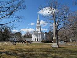
- First Congregational Church of Cheshire — 111 Church Drive (added March 16, 1973)
- Marion Historic District (added December 21, 1988)
Parks and recreation

The Farmington Canal Heritage Trail, a popular non-motorized recreational trail, runs through Cheshire along its route between Suffield, Connecticut to the north and New Haven, Connecticut to the south.[18]
The Hitchcock-Phillips House, a historic home, is located in town.
Roaring Brook Falls along the Quinnipiac Trail in the southwest corner of town is Connecticut's tallest single drop waterfall, and is owned by the Cheshire Land Trust.
Community parks and recreational facilities in town include:
- Cheshire Park, a 75-acre park geared towards active recreation[19]
- Bartlem Recreational Area, a park with a playscape, skate park and picnic area.[19]
- Mixville Recreation Area, offering swimming and fishing at Mixville Pond[19]
- Cheshire Community Pool, a swimming facility which was renovated in 2016 to offer a year-round, indoor pool.[20]
Education
Cheshire is home to one public high school, Cheshire High School, and one public middle school, Dodd Middle School.[21] There are four public elementary schools: Chapman, Doolittle, Highland, and Norton Elementary. Cheshire is also home to one public kindergarten, Darcey School.
There are also several private and alternative schools in the town, including Cheshire Academy (originally the Episcopal Academy of Connecticut), which was founded in Cheshire in 1794 and currently educates students in the Middle School (grade 8) and the Upper School (grades 9-12/Post-Graduate Year). St. Bridgets is a Catholic school in Cheshire for grades preschool to 8th grade. Humiston is an alternative high school in Cheshire.
The Legion of Christ, a Roman Catholic congregation, runs their novitiate and college of humanities on a 200-acre (0.81 km2) complex on Oak Avenue. About 100 seminarians undergo two to four years of training for the priesthood there, including religious formation and classical humanities.
Transportation

Transportation within Cheshire is largely by car. Interstate 691 skirts the northern edge of the town. Interstate 84 passes through the northwest part of the town. The main north-south artery is Connecticut Route 10, a difficult passage that is busy, sometimes congested, and includes many stoplights. There are two east-west routes: Route 42 and Route 68/Route 70. Route 10 is by far the busiest road in Cheshire, with the worst Route 10 traffic occurring between Routes 68/70 and Route 42 every weekday during the morning commute, evening commute, and after the high school gets out at 2 pm. West Main Street and Main Street, Route 68/70 between Route 10 and Waterbury Road, is the next busiest road in town. The intersection of Route 10 and Route 68/70 is the busiest intersection in town. The second busiest intersection is the Cheshire High School and Route 10 intersection right before school starts and right after school ends.[22]
The J line of Connecticut Transit New Haven which runs from Waterbury to New Haven travels through Cheshire on Routes 70 and 10. A commuter express bus also runs from the commuter lot near Interstate 84 to Hartford.
Prison system
Cheshire is home to two large state prison facilities located in the northern section of town. The larger of these facilities is the Cheshire Correctional Institution, which opened in 1913. In 1982, the Manson Youth Institution opened adjacent to the CCI. These prisons explain the city's skewed male/female ratios. The larger of these prisons is located across the street from Chapman Elementary School, separated by Route 10.[23]
Notable people
- Amos Bronson Alcott (1799–1888), schoolmaster
- Brad Ausmus, professional baseball player[24]
- Harvey C. Barnum, Jr., Medal of Honor recipient
- Henry Washington Benham (1813–1884), Union army general
- Chris Berman, ESPN sportscaster
- Jay Bontatibus, actor[25]
- Albert E. Burke (1919-1999), professor and pioneer of educational television
- John Chamberlain (1903–1995), journalist
- Michael Chasen, CEO of SocialRadar and Co-Founder of Blackboard Inc.
- Amos Doolittle (1754–1832), engraver of Battle of Concord scenes
- George Henry Durrie, painter
- Elizabeth Esty, U.S. Congresswoman
- Samuel A. Foot (1780–1846), 28th Governor of Connecticut, United States Representative and United States Senator[26]
- Seabury Ford (1801–1855), 20th Governor of Ohio[27]
- James J. Greco, businessman, lived in town from 1992-2011
- Sunil Gulati, President of the United States Soccer Federation
- Peter Hitchcock (1781–1854), judge
- John Holmstrom, cartoonist, writer
- John Frederick Kensett (1816–1872), painter[28]
- Brian Leetch, International Hockey Hall of Fame inductee
- Rollin Carolas Mallary, U.S. Representative from Vermont[29]
- Legs McNeil, journalist, rock music historian
- J. P. Morgan, businessman
- Chris Murphy, U.S. Senator
- Anjul Nigam, actor
- Matt Generous, ice hockey defenseman
- Ron Palillo, actor[30]
- Paul Pasqualoni, athletic coach
- Lonnie Quinn, meteorologist
- Ramamurti Shankar physicist
- Edward Tufte, professor
- Justin Tussing, novelist
- Vijay Vaitheeswaran, journalist
- James Van Der Beek, actor[31]
See also
 Connecticut portal
References
- ↑ "Cheshire Connecticut". City-Data.com. Retrieved September 19, 2012.
- ↑ http://www.cheshirect.org/agendas-and-minutes/town-council
- 1 2 3 Joseph Perkins Beach. History of Cheshire, Connecticut, from 1649 to 1840, including Prospect, which, as Columbia parish, was a part of Cheshire until 1829;. Cheshire, Conn., Lady Fenwick chapter, D. A. R. p. 590.
- ↑ "Profile of General Population and Housing Characteristics: 2010 Demographic Profile Data (DP-1): Cheshire town, New Haven County, Connecticut". U.S. Census Bureau, American Factfinder. Archived from the original on September 11, 2013. Retrieved September 26, 2012.
- ↑ "State Centers of Population 1880-2010: Connecticut". United States Census Bureau. Retrieved April 22, 2016.
- ↑ "Cheshire ATT". Cold War CT. Cold War CT. Retrieved 23 March 2016.
- ↑ "Inside Dateline – Oct. 8: 'The Mystery of Horseshoe Drive' and revisiting 'The Family on Sorghum Mill Drive'". Insidedateline.msnbc.msn.com. Retrieved January 30, 2011.
- ↑ "Annual Estimates of the Resident Population for Incorporated Places: April 1, 2010 to July 1, 2014". Retrieved June 4, 2015.
- ↑ "Census of Population and Housing". Census.gov. Archived from the original on May 11, 2015. Retrieved June 4, 2015.
- ↑ "American FactFinder". United States Census Bureau. Archived from the original on 2013-09-11. Retrieved 2008-01-31.
- ↑ American FactFinder, United States Census Bureau. "Cheshire town, New Haven County, Connecticut – Selected Economic Characteristics: 2005–2007". Factfinder.census.gov. Retrieved January 30, 2011.
- ↑ "Profile of General Population and Housing Characteristics: 2010 Demographic Profile Data (DP-1): Cheshire Village CDP, Connecticut". U.S. Census Bureau, American Factfinder. Archived from the original on September 11, 2013. Retrieved October 15, 2012.
- ↑ "Geographic Identifiers: 2010 Demographic Profile Data (G001): Cheshire town, New Haven County, Connecticut". U.S. Census Bureau, American Factfinder. Archived from the original on September 11, 2013. Retrieved September 26, 2012.
- ↑ "Monthly Averages for Cheshire, CT (06410)". Weather.com. Retrieved March 19, 2012.
- ↑ Enter your Company or Top-Level Office. "SOTS: Election Results and Related Data". Sots.ct.gov. Retrieved January 30, 2011.
- ↑ "GOP Wins In Landslide Fashion". The Cheshire Herald. November 5, 2009. Retrieved January 30, 2011.
- ↑ "TRAVEL ADVISORY; The Golden Days Of Lunch Boxes and Pez". New York Times. December 7, 1997. Retrieved March 23, 2007.
- ↑ "Farmington Canal State Park Trail". Connecticut Department of Energy and Environmental Protection. Connecticut Department of Energy and Environmental Protection. Retrieved 22 April 2016.
- 1 2 3 "Parks and Recreation Areas". Cheshire: The Bedding Plant Capitol of Connecticut. Town of Cheshire, Connecticut. Retrieved 22 April 2016.
- ↑ "Raise the Roof! Cheshire Pool Reopening for Winter Swimming". NBC Connecticut. NBC Universal Media, LLC. Retrieved 22 April 2016.
- ↑ "Cheshire Public Schools homepage". Cheshire.k12.ct.us. Retrieved January 30, 2011.
- ↑ http://www.ct.gov/dot/lib/dot/documents/dpolicy/policymaps/adt/dgn/025adt04.zip
- ↑ "chapman elementary school, cheshire, CT – Google Maps". Maps.google.com. January 1, 1970. Retrieved January 30, 2011.
- ↑ "Brad Ausmus Stats". Baseball Almanac. Retrieved October 30, 2012.
- ↑ "Jay Bontatibus". IMDb. Retrieved October 30, 2012.
- ↑ "FOOT, Samuel Augustus, (1780 - 1846)". Biographical Directory of the United States Congress. Retrieved October 30, 2012.
- ↑ "Ohio Governor Seabury Ford". National Governors Association. Retrieved October 30, 2012.
- ↑ "John Frederick Kensett Illuminates the 19th-Century Landscape". ConnecticutHistory.org. Connecticut Humanities. Retrieved 28 April 2016.
- ↑ "MALLARY, Rollin Carolas, (1784 - 1831)". Biographical Directory of the United States Congress. Retrieved October 30, 2012.
- ↑ "Ron Palillo". IMDb. Retrieved October 30, 2012.
- ↑ "James Van Der Beek". IMDb. Retrieved October 30, 2012.
External links
| Wikimedia Commons has media related to Cheshire, Connecticut. |
- Town of Cheshire official website
- Cheshire Public Library – The library has a Cheshire/Connecticut history section and will answer genealogical and historical questions about Cheshire and environs.
- First Congregational Church – Host of the Annual Strawberry Festival and "mother church" to other congregations in the area and along the Eastern Seaboard. The church steeple is an official symbol of the town, as it is depicted on the town seal.
- Barker Character, Comic and Cartoon Museum
- Saint Peter's Church
- Money Magazine 2011
- City-Data.com Comprehensive Statistical Data and more about Cheshire
Municipalities and communities of New Haven County, Connecticut, United States | ||
|---|---|---|
| Cities |  | |
| Towns |
*Consolidated borough and town | |
| Borough | ||
| Other communities | ||