Cherry Creek Bridge
| Cherry Creek Bridge | |
|---|---|
 | |
| Coordinates |
39°19′41″N 104°44′3.5″W / 39.32806°N 104.734306°WCoordinates: 39°19′41″N 104°44′3.5″W / 39.32806°N 104.734306°W |
|
Cherry Creek Bridge | |
| Nearest city | Franktown, Colorado |
| Area | less than one acre |
| Architect | Colorado Department of Highways; Monaghan, J.H.& N.M. & Associates |
| Architectural style | Two-rib open-spandrel arch |
| MPS | Highway Bridges in Colorado MPS |
| NRHP Reference # | 02001147[1] |
| CSRHP # | 5DA.1519 |
| Added to NRHP | October 15, 2002 |
| Carries | Passenger vehicles |
| Crosses | Cherry Creek |
| Locale | near Franktown, Colorado |
| Characteristics | |
| Total length | 374 ft (114 m) |
| Width | 29.8 ft (9.1 m) |
| Longest span | 232 ft (71 m) |
| History | |
| Construction end | 1948 |
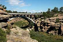
The Cherry Creek Bridge is a concrete arch bridge spanning Cherry Creek near Franktown, Colorado. State Highway 83 runs atop it. It was built in 1948 by J.H.& N.M. Monaghan & Associates and is listed on the National Register of Historic Places. It is located within Castlewood Canyon State Park.
Its design and construction are credited to the Colorado Department of Highways and J.H.& N.M. & Associates.[1]
It was a post-war exception to the practice of using lighter concrete bridge designs in the state.[2] :77
See also
References
- 1 2 National Park Service (2009-03-13). "National Register Information System". National Register of Historic Places. National Park Service.
- ↑ Clayton B. Fraser. (March 30, 2000). "Highway Bridges in Colorado MPS" (PDF). National Park Service.
| Topics | |
|---|---|
| Lists by states |
|
| Lists by insular areas | |
| Lists by associated states | |
| Other areas | |
| |
This article is issued from Wikipedia - version of the 9/20/2016. The text is available under the Creative Commons Attribution/Share Alike but additional terms may apply for the media files.