Charlottenburg-Nord
| Charlottenburg-Nord | |
|---|---|
| Quarter of Berlin | |
|
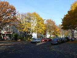
Charlottenburg-Nord, Halemweg | |
 Charlottenburg-Nord | |
Location of Charlottenburg-Nord in Charlottenburg-Wilmersdorf and Berlin 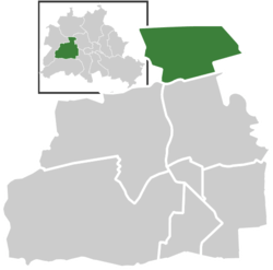 | |
| Coordinates: 52°32′20″N 13°17′35″E / 52.53889°N 13.29306°ECoordinates: 52°32′20″N 13°17′35″E / 52.53889°N 13.29306°E | |
| Country | Germany |
| State | Berlin |
| City | Berlin |
| Borough | Charlottenburg-Wilmersdorf |
| Founded | 2004 |
| Area | |
| • Total | 6.2 km2 (2.4 sq mi) |
| Population (2008-06-30) | |
| • Total | 17,327 |
| • Density | 2,800/km2 (7,200/sq mi) |
| Time zone | CET/CEST (UTC+1/+2) |
| Postal codes | (nr. 0406) 13627 |
| Vehicle registration | B |
Charlottenburg-Nord is a locality (Ortsteil) in the northern part of the Charlottenburg-Wilmersdorf borough of Berlin, Germany. It is chielfy composed of after-war housing estates, allotment gardens and commercial zones. The locality comprises the Großsiedlung Siemensstadt, part of the Berlin Modernism Housing Estates UNESCO World Heritage Site, as well as Plötzensee Prison.
Geography
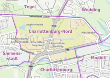
Charlottenburg-Nord is situated in the western suburbs of Berlin, beyond the Ringbahn line of the Berlin S-Bahn. In the north the Berlin-Spandau Ship Canal forms the border with Reinickendorf and Tegel, a bridge leading right to the southern entrance of Berlin Tegel Airport. It further borders with Siemensstadt (part of the Spandau borough) in the west. In the east and south the Berlin-Spandau Ship Canal and the Westhafen Canal mark the border with the inner city localities of Wedding and Moabit (both part of the Mitte borough) and Charlottenburg.
The locality is subdivided in several zones (Ortslagen) like the Großsiedlung Siemensstadt and Siedlung Charlottenburg-Nord housing estates in the west, the Jungfernheide municipal park as well as the Paul-Hertz-Siedlung and Plötzensee in the east with the Roman Catholic commemorative church Maria Regina Martyrum, honouring the Martyrs of Freedom of Belief and Conscience that were executed at Plötzensee Prison during the Nazi era in the years from 1933 to 1945. Together with the nearby Protestant Church of Plötzensee, it is the site of the annual Ecumenical Plötzensee Days.
History
The locality was created in 2004, when it was separated from Charlottenburg in the south. Since the 1920 Greater Berlin Act, the area had been part of the Charlottenburg borough (Bezirk Charlottenburg), united with Wilmersdorf in the 2001 administrative reform.
Transport
The Bundesautobahn 100 (Stadtring) motorway runs through the south of the locality, where the interchange on Jakob-Kaiser-Platz (Dreieck Charlottenburg) connects the Bundesautobahn 111 leading northwards to the Berliner Ring (A 10) motorway. The adjacent areas are strongly affected by noise and pollution.
Air Berlin has its headquarters in Building 2 of the Airport Bureau Center in Charlottenburg-Nord.[1][2] As of 2006 Air Berlin employed 1,200 employees at its headquarters.[3] Germania has its headquarters in Charlottenburg-Nord.[4]
Regarding urban rail transports, Charlottenburg-Nord is served both by U-Bahn and S-Bahn, at the stations of Jungfernheide (S4, U7 and DB Regional-Express service), Jakob-Kaiser-Platz (U7) and Halemweg (U7).
References
- ↑ "Contact." Air Berlin. Retrieved on 12 May 2009.
- ↑ "Approach map." Air Berlin. Retrieved on 12 May 2009.
- ↑ Schulz, Stefan. "Ein Kandidat geht auf Tuchfühlung." Die Welt. 2 March 2006. Retrieved on 22 October 2009. "Am Saatwinkler Damm ist das Unternehmen mit 1200 Mitarbeitern (insgesamt 2700 Mitarbeiter) einer der größten Arbeitgeber der Hauptstadt."
- ↑ "Contact." Germania Airline. Retrieved on October 12, 2009.
External links
![]() Media related to Charlottenburg-Nord at Wikimedia Commons
Media related to Charlottenburg-Nord at Wikimedia Commons
| |