Bhimeshwar
| Bhimeshwar भिमेश्वर | |
|---|---|
| Municipality | |
|
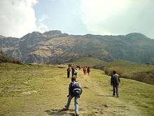
Landscape near Charikot; from North of the town | |
 Bhimeshwar Location in Nepal | |
| Coordinates: 27°40′0″N 86°2′0″E / 27.66667°N 86.03333°ECoordinates: 27°40′0″N 86°2′0″E / 27.66667°N 86.03333°E | |
| Country |
|
| Province | Province No. 3 |
| District | Dolakha District |
| Population (2011) | |
| • Total | 22,537 |
| Time zone | Nepal Time (UTC+5:45) |
| Postal code | 45500 |
| Area code(s) | 049 |

Bhimeshwar, (formerly Charikot), is a municipality in north-eastern Nepal and the headquarters of Dolakha District in Province No. 3 to be newly formed. At the time of the 1991 Nepal census it had a population of 7349 people residing in 1541 individual households.[1] The town is located at an altitude of 1554 metres (5101 feet).[2] The name of the district Dolakha came from Dolakha Town situated north-east of the headquarters Charikot Bazaar.
Boundaries
The region is bordered by the Sun Kosi River on the west and the Khimti Khola River on the east. It is divided unequally by the River Tama Koshi, proportionately two thirds to the west of the river and one third to the east.
To the north east lies the impressive Rolwaling Himal to the western edge of which are such peaks as Gauri Shankar and Melungtse. Gauri Shankar is synonymous with the god Shiva and his consort Parvati.
Places around Dolakha District and Bhimeshwar Municipality
- Dolakha Bhimeshwar*
This is the one of the oldest temple of Dolakha, this temple is situated at toward the east of Charikot Bazaar which is 4.5 kilometers. Thousands of pilgrims come to this temple every year. According to the Hindu mythology Bhimsen is one of the brothers of Pandava, during their 12 years exile they spent a year in Dolakha and they used to speak a language for that year called Dolakhali Newari language. Newari people regarded the Bhimeswar as a suprime god.
- Kotihom —
A very religious and historic place situated at the northern-east side of the main town. Approximately 25 mins of walk from the bus stop of Charikot. A Priest from Kalinchok - another religious place in far Northern Himalayan region of the Charikot, initiated the work to establish this holy shrine. Late King Birendra Bikram Shah Birendra of Nepal and Late queen Aishwarya Rajya Laxmi Devi Shah Aishwarya of Nepal were invited for the inauguration of this shrine. In Nepal, Kings and Queens were regarded as reincarnation of the Protector of all living being Vishnu. So it was a huge ceremony for the people of Charikot on that auspicious occasion of their visit and inauguration. Every 12 years, People of Charikot and around they visit the place to celebrate 'Holm'-a religious mass act without any scarification of living creature for peace of the Nation and the World.
- Pashupati —
A temple situated at the top of a hill near Purano Bazaar. People like to go there for worship every morning. It is similar to the Pashupati temple of Kathmandu in a sense it also has Shiva Linga. The temple is surrounded by walls and within its perimeters is Lali Guras Youth Club.
- Gumba —
It is a monastery at the top of the other corner of this beautiful town in south. A wide road enough for a bus takes from Satdobato through the residential area. It is in wide and open field and has scenic view of almost all the area of Dolakha District-Mahangkal, Mude, Kalinchok, Charikot, Dolakha, Gaurishankar Himalayan Range, Tamakoshi. It is a truly breathtaking spot for scenic sips.
- Mahangkal —
When you have sorrows and hurdles, they say, go and pray in this holy place. Females are prohibited to enter into the main temple for unknown reason. It lies near the bank of Charnawoti river which soon would join Tamakoshi to become huge Tamakoshi. You can walk or you can take ride with local bus or bike, its your choice. Half hour tour is worth visiting.
- Tundekhel-Playground for the whole town and any other festivals.
- Deurali
- Kalinchok
 Adventurous Hiking route in Charikot-Kalinchok
 - Tripurasundari
 Tripurasundari
 - Sundrawati
- Charnawati
- Tamakoshi
- Boch
- Jiri
- Eco Himal Trekking Route
- Jilu Village "Land of Food and Devotes
- Mahankal "Brinda Ban" where you could see the magnificent views of Mt. Gaurishanker with Rolwaling range and white river Tamakoshi
- Tsho Rolpa Trekking Route
- Khimti hydro project.
Geography
To the northwest the mountains slope gently downwards towards the ancient pass of Kuti that starts above the Tibetan town of Khasa and follows the waters of the Bhote Kosi from Tibet. The river flows past Kodari and Tatopani (Hot Springs) on the Nepalese side and gradually rushes down into an ever-widening stream of water that becomes the Sun Kosi.

The Khimti Khola drains down from a region of five lakes called Panch Pokhari. They have a specific place in legend and go by the names of Mohi (buttermilk), Jata (hair), Dudh (milk), Bahula (insane), and Bhut (ghost). People believe that if one bathes in Bahula Pokhari one will become insane, whereas the Ghost Lake cannot bear the smell of human perspiration and will pull one inside its murky waters to a certain death if you as much as venture near it. The Khimti Khola joins the Tama Koshi, as do the Khare Khola and Rolwaling Khola to the northeast and the Sangawati, Dolti and Charnewati Kholas to the west.
The riverine valleys open out into massive volcanic folds. Sub-tropical settlements on the banks of rivers boast banana trees, guava, and an abundance of fish. Above the banks hover the terraced fields of paddy, make, wheat, and millet.
Between Bhimeshwar and Jiri the road descends to 845 metres and is bordered by plantations of sugar-cane. Above these slopes are forests of dark oak, fir and pine, interspersed with tangles of bracken and fem all in the embrace of clinging orchids and coloured in the springtime by the rhododendrons, the national flower of Nepal.
Mosses cling to the shaded rocks and in the forests are wild strawberries, loganberries, red berries and thyrne.
Destination
Dolakha is approximately 139 km from the Capital of Nepal, Kathmandu. Regular-Local and Express bus services are available from the Old Bus Station. All the Bus services are operated by Araniko Transportation Authority as per Syndicate System. Old Bus Park is situated opposite Play Ground-Tundekhel.
Students can get 45% discount in regular bus fare. Anyone can get a ride from virtually any spot in the route. Previously, one could ride in the hood but recently the law was passed not to allow anyone to ride over the hood.
The popular destination from Old Bus Park en route to Dolakha are many. Banepa, Dhulikhel, Dolal-Ghat, Lamo-Sangu (Long Bridge), Khadi Chaur (Middle Eastern Ground),and Mude. Tourists and local enjoy the travel and scenic views, foods on the route equally. Dolal-Ghat and Khadi Chaur are major destination for fish, Dolal-Ghat for vegetables (esp. tomatoes), Dhulikhel for restaurants and resorts.
Rafting in the Sunkoshi (Gold River) and Tamba koshi is also a major attraction.
Schools and Colleges
Government Schools
- Shree Kalinchwok Higher Secondary School
- Shree Pashupati Higher Secondary School
- Shree Bhim Higher Secondary School
- Shree Sharba Mabi Jilu
- Shree Satya Shor Uchha Mabi Powati
Private Boarding Schools
- The Rising Star English Boarding School
- Mount Valley English Boarding School
- Tripura Glorious Academy
- Apline English Boarding School
Government College
- Gaurishankar Multiple Campus
Hospitals and Nursing Homes
Government
- District Education Office
- District Health Post
- Primary Health Centre
Private Hospitals
- Tsho Rolpa General Hospital and Nursing College
- Dirghau General Hospital
- Gaurishankar General Hospital (formerly under Korean aid)
- The Rising Star School
Government offices
- Bhimeshwar Municipality Office
- District Public Health Office
- Road and construction Office
Banks
- Prabhu Bank
- Laxmi Bank
- Nabil Bank
- Nepal Bank Limited
- Agricultural Development Bank
- Soorya Development Bank
- Infrastructure Development Bank
- Diyalo Bikash Bank
- Kalinchowk Development Bank
- Yeti Development Bank Ltd
- Citizen Bank International
- Century Commercial Bank
- Sindhu Bikash Bank
Ethnic groups
Newars are mostly involved in small local business, Nepali in clothing stores.

Brahmins-Indo-Aryan; Referred to twice-born. They have been the dominant priestly cast of Nepal since Prithvi Narayan Shah of Gorkha unfied the states of Nepal into a single Kingdom.
Jirel-Tibeto-Mongoloid; It is believed that they may be descendants of original inhabitants of Tibet and Tibetan tribes with whom they inter-married. Broadly speaking, Jirels have retained a Buddhist tradition. However, they employ Hindu Brahmins for many rituals. This behavior may date back to the Rana rule, a Hindu dynasty. They live in Jiri and the village nearby. They believe they originated as a result of trade between this region and the adjoining regions in Tibet. At death ceremonies, a Buddhist tradition prevails. However, for many domestic ceremonies they call a Brahmin priest and adhere to the brahmanical tradition. This strange mixture can be explained by their mixed ethnic origins and that sometimes amongst certain of the middle-hill peoples there is no hard, dividing line.
Other- Ksehtri, Magar, Newar, Sherpa,Tamang, Thami
References
- ↑ "Nepal Census 2001", Nepal's Village Development Committees, Digital Himalaya, archived from the original on 2008-10-12, retrieved 7 December 2016.
- ↑ Charikot, Nepal Page
External links
| Wikimedia Commons has media related to Charikot. |
Headquarter: Bhimeshwar | ||
|  | |