Charentonne
| Charentonne | |
|---|---|
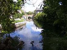 The Charentonne in Bernay | |
| Country | France |
| Basin | |
| Main source | Normandy |
| River mouth |
Risle 49°7′26″N 0°43′37″E / 49.12389°N 0.72694°ECoordinates: 49°7′26″N 0°43′37″E / 49.12389°N 0.72694°E |
| Progression | Risle→ Seine→ English Channel |
| Basin size | 513 km2 (198 sq mi) |
| Physical characteristics | |
| Length | 63 km (39 mi) |
| Discharge |
|
The Charentonne is a 63 km long river in Normandy, left tributary of the Risle. The river begins in pays d'Ouche (Orne), in the forest of Saint-Évroult, in the south of the Saint-Évroult-Notre-Dame-du-bois village and the ruins of the abbey where lived and died Orderic Vitalis (1075–1142).
The river runs, in a north-northeast direction, towards the Risle with which it joins at Serquigny.
The Charentonne valley, which separates the Lieuvin plateau and the Ouche plateau has stiff and wooded slopes. The bottom of the valley is covered with clayed alluvions ; it is flat and wet, flooded in winter, with beautiful natural meadows, characteristic of Normandy.
The Charentonne flows through the following communes: Broglie, Bernay.
References
| Wikimedia Commons has media related to Charentonne. |
This article is issued from Wikipedia - version of the 5/6/2016. The text is available under the Creative Commons Attribution/Share Alike but additional terms may apply for the media files.