Chain of Craters Road
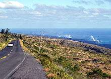
Chain of Craters Road is a 19-mile/30-km winding paved road through the East Rift and coastal area of the Hawaii Volcanoes National Park on the island of Hawaii, in the state of Hawaii, United States. The original road, built in 1928, connected Crater Rim Drive to Makaopuhi Crater. The road was lengthened to reach the tiny town of Kalapana in 1959. The road has had parts covered by lava several times due to eruptions of the Kīlauea volcano.[1]
Route description

The road has paths and road offshoots that allow access to various volcanic views such as pit craters, active and dormant lava flows, plumes from lava tubes and various geographic sites that can be accessed by trails from the road. Caution is urged as these areas are dangerous. There are also scenic views through tropical rainforests, and the seacoast. Next to the park's Visitor Center is the 10-mile (16 km) paved Crater Rim Drive around Kilauea caldera, off which a short paved road leads to a viewpoint overlooking Kīlauea, the origin of the 1995 eruption that closed the Chain of Craters Road.[2]
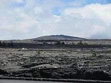
The road begins at 19°24′18″N 155°15′10″W / 19.40500°N 155.25278°WCoordinates: 19°24′18″N 155°15′10″W / 19.40500°N 155.25278°W, the highest part of the eastern rift zone where frequent rains created a rainforest. 3 mi (4.8 km) down the road is the vent of Kīlauea volcano.[3] The road goes another 2 mi (3.2 km), passing the group of craters for which the road is named and then crosses a narrow flow of pāhoehoe lava that erupted in 1974 before it reaches Lua Manu, the first pit crater.[4] The crater formed through a sinking of the earth surface and not as primarily a vent for lava.[5]
Here lava spilled into the crater in 1974 but did not fill it. The collapsed rubble-filled Puhimau, the second pit crater is 500 feet deep. This crater and the next, a dirt pit crater, Koʻokoʻolau, give no idications of recent eruptions. However Koʻokoʻolau has pumice cones on the rim that suggest it formed originally as an eruptive vent. The road runs into Hilina Pali Road, a winding eight-mile road that dead ends. The road passes Pauahi crater, and fresh fault scarp that have been active for more than 1000 years. The road continues through a forest, Kipuka Nene, 1,100-year-old trees surrounded by fresh lava.
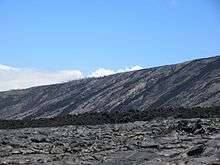
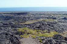
Toward the sea the road crosses a pāhoehoe lava flow. Here can be seen steam from lava tubes.[6]
Lava flows from the Kīlauea volcano eruption closed the road in 1969. In 1979 the road was reopened, but it was cut again in 1986 by a lava flow from another eruption of Kīlauea, a volcano that is one of Earth's most active.[7][8] As of 2014, Chain of Craters Road is about 19 miles (30 km) long to where it deadends, with the remaining 7.5 miles (12 km) of it buried by lava from different flows from Puʻu ʻŌʻō since 1986. In all, it descends 3,700 feet between Crater Rim Drive and the barren, windy south coast.[3][9]
Between September and November, 2014, work was carried out to reopen Chain of Craters Road, initially as a one-lane graveled surface, to serve as an emergency road for the residents of Lower Puna, who were in danger of being cut off if the June 27 flow had crossed highway 130 at Pāhoa.[10][11] The flow ultimately stalled on the outskirts of Pāhoa, however, removing the immediate threat, and the route was again buried by lava by the "61G" flow in 2016.
Conditions
Even when no active lava is visible, Chain of Craters Road is an exceptionally scenic and spectacular drive,[3] but it can be hazardous under poor conditions. Moreover, because of the dangers posed by an active volcano, the US Geological Survey posts a daily conditions report which should be checked before driving on the Chain of Craters Road or taking any of its offshoots or trails. In April 2008 the area was rated as dangerous with a high alert because of volcanic activity and sulfuric gas.[12]
Services
There are no services such as shops or gas stations along the road, except a refreshment kiosk and public toilets at the bottom end of the road, at the point where further access is for emergency only as it was blocked by lava.
See also
References
- ↑ Decker, Robert & Barbara. "Chain of Craters Road". Road Guide to Hawaii Volcanoes National Park. Dartmouth College. Retrieved 2009-12-12.
- ↑ "Chain of Craters Road". www.byways.org. Retrieved 2009-09-15.
- 1 2 3 Mattox, Steve. "Chain of Craters Road". volcano.und.edu. Retrieved 2008-04-11.
- ↑ "Mauna Ulu". volcano.und.edu. Retrieved 2008-04-12.
- ↑ "Volcanic and Geologic Terms". volcano.und.edu. Retrieved 2008-04-12.
- ↑ Donald W. Hyndman, Richard W. Hazlett & (2005). Roadside Geology of Hawai'i. Missoula, MN: Mountain Press Publishing. pp. 81–87. ISBN 0-87842-344-3.
- ↑ "Kīlauea Volcano". www.soest.hawaii.edu. Retrieved 2008-04-13.
- ↑ "Introduction to Kilauea Volcano, Hawai`i". hvo.wr.usgs.gov. Retrieved 2008-04-13.
- ↑ "Kilauea". www.volcanoinn.com. Retrieved 2008-04-12.
- ↑ TOM CALLIS and COLIN M. STEWART Tribune-Herald staff writers. "Chain of Craters Road construction to begin Tuesday". Hawaii Tribune-Herald.
- ↑ Big Island Video News. "Chain Of Craters Road Update: Rough Grade Complete". Big Island Video News.
- ↑ "HVO Kilauea Status Page". volcano.wr.usgs.gov. Retrieved 2008-04-14.
Further reading
- Decker, Robert; Barbara Decker (2007). Road Guide to Hawaiʻi Volcanoes National Park (6th ed.). Mariposa, CA: Double Decker Press. ISBN 1-888898-11-9.
External links
- A Tour of Loihi: The New Summit Pit Crater
- Kilauea Volcano
- Current Recent Kilauea Status Reports, Updates, and Information Releases
- Hawai'i Volcanoes National Park closures and advisories
- "Live Panorama of Halema`uma`u, Kilauea Volcano, Hawai`i". Hawaiian Volcano Observatory. Retrieved 2009-12-12.
- Chain of Craters history
- Summary of the Pu`u `O`o-Kupaianaha Eruption, 1983-present
Hawaiian volcanism topics (list) | ||
|---|---|---|
| Windward Isles |  | |
| Leeward Isles | ||
| Emperor Seamounts | ||
| Topics | ||