Châteaubourg, Ille-et-Vilaine
| Châteaubourg Kastell-Bourc'h | ||
|---|---|---|
|
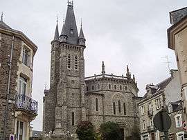
Saint-Pierre church | ||
| ||
 Châteaubourg | ||
|
Location within Brittany region  Châteaubourg | ||
| Coordinates: 48°06′43″N 1°24′07″W / 48.1119°N 1.4019°WCoordinates: 48°06′43″N 1°24′07″W / 48.1119°N 1.4019°W | ||
| Country | France | |
| Region | Brittany | |
| Department | Ille-et-Vilaine | |
| Arrondissement | Fougères-Vitré | |
| Canton | Châteaubourg | |
| Intercommunality | Vitré Communauté | |
| Government | ||
| • Mayor (2014–2020) | Teddy Régnier | |
| Area1 | 28.60 km2 (11.04 sq mi) | |
| Population (2008)2 | 5,966 | |
| • Density | 210/km2 (540/sq mi) | |
| Time zone | CET (UTC+1) | |
| • Summer (DST) | CEST (UTC+2) | |
| INSEE/Postal code | 35068 / 35220 | |
| Elevation | 35–117 m (115–384 ft) | |
|
1 French Land Register data, which excludes lakes, ponds, glaciers > 1 km² (0.386 sq mi or 247 acres) and river estuaries. 2 Population without double counting: residents of multiple communes (e.g., students and military personnel) only counted once. | ||
.svg.png)
Châteaubourg (Breton: Kastell-Bourc'h, Gallo: Chastèu-Bórg) is a commune in the Ille-et-Vilaine department in Brittany in northwestern France.
Population
Inhabitants of Châteaubourg are called Castelbourgeois in French.
| Historical population | ||
|---|---|---|
| Year | Pop. | ±% |
| 1962 | 2,352 | — |
| 1968 | 2,634 | +12.0% |
| 1975 | 2,937 | +11.5% |
| 1982 | 3,526 | +20.1% |
| 1990 | 4,056 | +15.0% |
| 1999 | 4,877 | +20.2% |
| 2008 | 6,450 | +32.3% |
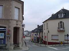 Châteaubourg Inner town
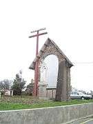 Saint-Melaine calvary
 Saint-Pierre church
 «Ar Milin» stepping over the Vilaine
 Saint-Melaine church
 Old town house
See also
References
External links
| Wikimedia Commons has media related to Châteaubourg (Ille-et-Vilaine). |
This article is issued from Wikipedia - version of the 8/1/2015. The text is available under the Creative Commons Attribution/Share Alike but additional terms may apply for the media files.