Cerro Batoví
| Cerro Batoví | |
|---|---|
 Cerro Batoví, situated near Tacuarembó | |
| Highest point | |
| Elevation | 224 m (735 ft) |
| Listing | Breast-shaped hills |
| Coordinates | 31°52′33″S 56°00′41″W / 31.87583°S 56.01139°WCoordinates: 31°52′33″S 56°00′41″W / 31.87583°S 56.01139°W |
| Naming | |
| Translation | Cerro (Hill in Spanish); Batoví (Breast of a virgin in Guaraní) (Spanish/Guaraní) |
| Pronunciation | Spanish: [ˈθero βatoˈβi] |
| Geography | |
 Cerro Batoví Uruguay | |
| Location |
Tacuarembó, Tacuarembó Department, Uruguay |
| Parent range | Cuchilla de Haedo |
| Geology | |
| Age of rock | Precambrian |
| Mountain type | Hill |
| Climbing | |
| Easiest route | Hike |
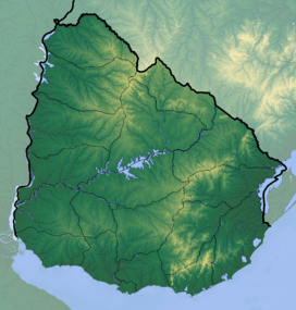
Cerro Batoví is a hill in Uruguay, with an altitude of 224 metres (734.9 ft). It is situated 25 km (15.5 mi) away from the city of Tacuarembó.
Location and features
It is located in the Tacuarembó Department, in a range of hills named Cuchilla de Haedo. Batoví means breast of a virgin in the Guaraní language and the hill has this name due to its curious shape.
Cerro Batoví is considered the symbol of the Tacuarembó Department.
See also
External links
- (Spanish) Enciclopedia Geográfica del Uruguay.
| Wikimedia Commons has media related to Cerro Batoví. |
Capital: Tacuarembó | ||
| Towns and villages | 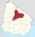 | |
| Sights | ||
This article is issued from Wikipedia - version of the 12/6/2015. The text is available under the Creative Commons Attribution/Share Alike but additional terms may apply for the media files.