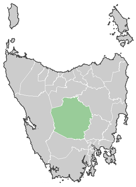
Central Highlands Council
| Central Highlands Council Tasmania | |||||||||||||
|---|---|---|---|---|---|---|---|---|---|---|---|---|---|
 Central Highlands Council | |||||||||||||
| Coordinates | 42°12′36″S 146°39′36″E / 42.21000°S 146.66000°ECoordinates: 42°12′36″S 146°39′36″E / 42.21000°S 146.66000°E | ||||||||||||
| Population | 2,322 (2010)[1] | ||||||||||||
| • Density | 0.29111/km2 (0.75397/sq mi) | ||||||||||||
| Area | 7,976.4 km2 (3,079.7 sq mi) | ||||||||||||
| Mayor | Deirdre Flint | ||||||||||||
| Council seat | Hamilton | ||||||||||||
| Region | Central Highlands | ||||||||||||
| State electorate(s) | Lyons | ||||||||||||
| Federal Division(s) | Lyons | ||||||||||||
|
| |||||||||||||
| Website | Central Highlands Council | ||||||||||||
| |||||||||||||
The Central Highlands Council is a local government area in the central highland region of Tasmania. It is the second largest Local Government Area of Tasmania, after the West Coast, and the least densely populated, with only 0.3 people per square kilometre.
Government
| Name | Position[2] | Party affiliation | |
|---|---|---|---|
| Deirdre Flint OAM | Mayor/Councillor | Independent | |
| Andrew Downie | Deputy Mayor/Councillor | Independent | |
| Jim Allwright | Councillor | Independent | |
| Tony Bailey | Councillor | Independent | |
| Richard Bowden OAM | Councillor | Independent | |
| Robert Cassidy | Councillor | Independent | |
| Evan Evans | Councillor | Independent | |
| Erika McRae | Councillor | Independent | |
| Loueen Triffit | Councillor | Independent | |
Parks and reserves
It covers most of the mountainous centre of the state, also known as the Central Plateau which contains the Central Plateau Conservation Area including sections of the Tasmanian Wilderness World Heritage Area, as well as the Cradle Mountain-Lake St Clair National Park, and Walls of Jerusalem National Park. Other smaller reserves of different status occur in the region as well.
Towns
The population of the area is small and quite decentralised, resulting in a large number of small towns. Some of these towns were founded as support sites for workers on the hydro-electric dams scattered along the upper Derwent River. Main towns are considered Hamilton (council headquarters) and Bothwell, but the largest town is Tarraleah.
The towns (with population as of 2006):
- Bothwell (376)
- Bronte Park (16)
- Derwent Bridge (?)
- Hamilton (300)
- Liawenee (?)
- Miena (104)
- Ouse (137)
- Tarraleah (500)
Townships
The municipality is subdivided into eight townships:[3]
- Hamilton Township
- Ouse Township
- Gretna Township
- Ellendale Township
- Fentonbury Township
- Westerway Township
- Wayatinah Township
- Bothwell Township
Population
Central Highlands Council have the second highest birth rate in all of Tasmania and one of the highest birth rates for all of Australia. The TFR was estimated at 3.20 in 2006. Source. Only George Town with a TFR of 3.75 had a higher birth rate than Central Highlands. . TFR was reported at 3.46 in 2007.
Region
Some tourism materials combine the LGA area with that of the Derwent Valley to call it Derwent Valley and Highlands region [4]
References
- ↑ Australian Bureau of Statistics (31 March 2011). "3218.0 - Regional Population Growth, Australia, 2009-10". Retrieved 23 August 2011. Estimated resident population (ERP) at 30 June 2010.
- ↑ "Councillor Details - Central Highlands Council". centralhighlands.tas.gov.au. Central Highlands Council. Retrieved 1 February 2015.
- ↑ "Archived copy" (PDF). Archived from the original (PDF) on 2009-05-23. Retrieved 2009-06-09.
- ↑ http://www.about-australia.com/tasmania/derwent-valley-highlands/
Further reading
- Jetson, Tim.(1989) The roof of Tasmania: a history of the Central Plateau Launceston, Tas.: Pelion Press. ISBN 0-7316-7214-3
External links
Local government areas of Tasmania grouped by areas | ||
|---|---|---|
| Central | ||
| Hobart area | ||
| Launceston area | ||
| North-east area | ||
| North-west and west coast | ||
| South-east area | ||