Cecil Peak
Cecil Peak is a mountain in the Wakatipu Basin, New Zealand and reaches a height of 1,978 metres.[1] It is on the south side of Lake Wakatipu, south south-west of Queenstown and is highly prominent from around this area. [2]
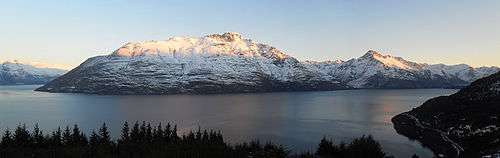
Vegetation is mainly grass and tussock (as it is under a pastoral lease[3]) with trees near the waterline. Hidden Island is one of four islands in Lake Wakatipu and sits very close to the shoreline of Cecil Peak. On 27 March 2010 a local band performed an outdoor concert in a natural amphitheatre on the peak playing songs from the band Pink Floyd.[4]
Name
Both Cecil Peak and the nearby mountain of Walter Peak were named after William Rees' eldest sons' first given names by the surveyor James McKerrow in 1862.[5]
See also
References
- ↑ Malcolm, McKinnon. "Otago places - Wakatipu basin". Te Ara - the Encyclopedia of New Zealand.
- ↑ "Ngai Tahu Names" (PDF). Te Karaka Issue 44, pg 13. tekaraka.co.nz. Retrieved 18 September 2013.
- ↑ "Crown Pastoral Land Tenure Review" (PDF). Land Information New Zealand.
- ↑ "Rocking it on Cecil Peak". Scoop Media.
- ↑ Jardine, D.G. (1978). Shadows on the Hill. A.H. & A.W. Reed Ltd. p. 185. ISBN 0589010093.
Coordinates: 45°06′32″S 168°37′42″E / 45.108831°S 168.628463°E