Cave-in-Rock State Park
| Cave-In-Rock State Park | |
|---|---|
|
IUCN category III (natural monument or feature) | |
 | |
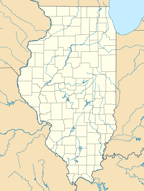 Map of the U.S. state of Illinois showing the location of Cave-In-Rock State Park | |
| Location | Hardin County, Illinois, U.S. |
| Nearest city | Elizabethtown, Illinois |
| Coordinates | 37°28′07″N 88°09′21″W / 37.46861°N 88.15583°WCoordinates: 37°28′07″N 88°09′21″W / 37.46861°N 88.15583°W |
| Area | 204 acres (83 ha) |
| Established | 1929 |
| Governing body | |
|
Cave-In-Rock | |
| Location | 0.5 mi N of the town of Cave-In-Rock, Cave-In-Rock, Illinois |
| Area | less than one acre |
| Built | 1861 |
| Architectural style | Other, natural cave |
| MPS | Caught in the Middle: The Civil War on the Lower Ohio River MPS |
| NRHP Reference # | 98000984[1] |
| Added to NRHP | August 6, 1998 |
Cave-In-Rock State Park is an Illinois state park, on 240 acres, in the town of Cave-in-Rock, Hardin County, Illinois in the United States. The state park contains the historic Cave-in-Rock, a landmark of the Ohio River. It is maintained by the Illinois Department of Natural Resources (IDNR).[2]
Geology

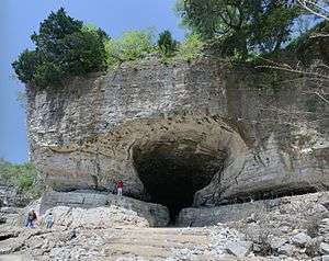
The Cave-in-Rock was worn into the limestone bluffs of the Ohio by river floods, especially during the meltoff following the Wisconsin ice age. It is not a karstland cavern like Mammoth Cave in nearby Kentucky; it is an obvious, 55-foot-wide (17 m) tunnel leading a long distance into the bluff.[2]
History
.jpg)
Cave-in-Rock was known and used for thousands of years by the Native Americans. It was mapped and named in 1729 by the French explorer M. de Lery, who named it the Caverne dans le Roc. This name, translated directly into English, is the name the cave bears to this day.
During the 1790s and the first three decades of the 19th century, Cave-in-Rock reached the height of its notoriety. Flatboats carrying farm produce from Kentucky, Ohio, and southern Indiana began to float down the Ohio River towards the marketplace in New Orleans. As a known Ohio River landmark, the cave was a landmark of this dangerous journey. From approximately 1797 until 1799, the cave was a hideout for a notorious gang of bandits, headed by Samuel Mason, that preyed upon the lawless river commerce.[2] The outlaws Frank and Jesse James of the notorious James Gang also hid out in the cave, according to local lore, leaving their marks in the cave.
Later in the 19th century, Cave-in-Rock was tamed by settlers who formed the river town of Cave-in-Rock, Illinois near the cave. The town survives to this day. It became the site of a river ferry, adjacent to the state park, that crosses the Ohio River from Illinois Route 1 to Kentucky Route 91.[3]
The Cave

.
Cave-in-Rock's primary feature is a striking 55-foot (17 m)-wide riverside cave formed by wind and water erosion and cataclysmic effects of the 1811–12 New Madrid earthquakes at Cave-in-Rock State Park 37°28′07″N 88°09′21″W / 37.46861°N 88.15583°W, just upriver from the village.
The first European to come across it was M. de Lery of France, who found it in 1729 and called it "caverne dans Le Roc" (cf. supra). Other names for the cave include Rock-In-Cave, Rocking Cave, Rock-and-Cave, House of Nature, The Cave, Big Cave, and Murrell's Cave. The cave has been the main feature of Illinois' Cave-in-Rock State Park since 1929.[4]
State park
With the inauguration of steamboat traffic on the Ohio River in the 1810s, travelers such as artist Karl Bodmer bought tickets to steam up and down the river, and Cave-in-Rock has been a recognized landmark of river tourism ever since. In 1929, the state of Illinois acquired 64.5 acres of land, including the cave. Other small parcels of land were acquired later to form the current park. The state park, which stretches from the river's edge to the top of the adjacent 60-foot-tall (18 m) bluff, is maintained by IDNR for Ohio River access, camping, and hiking, including hikes to the historic cave.[2]
In book, film, and television
In L.A. Meyer's historical novel Mississippi Jack, which takes place in 1805, series protagonist Jacky Faber encounters outlaws at Cave-in-Rock while bringing her showboat down the river. She and her cohorts kill the outlaws and report the results of the battle to some locals, hoping that they will send people to Cave-in-Rock before it can be taken over by outlaws once again, though she notes, "Prolly not."
References
- ↑ National Park Service (2010-07-09). "National Register Information System". National Register of Historic Places. National Park Service.
- 1 2 3 4 Joe McFarland, "The Hole in the River", Outdoor Illinois XVIII:11 (November 2010), pages 2-5.
- ↑ Illinois Atlas and Gazetteer. Freeport, Maine: DeLorme Mapping. 1991. ISBN 0-89933-213-7.
- ↑ "Cave-In-Rock - State Park". Illinois Department of Natural Resources.
External links
- "Cave-in-Rock - State Park". Illinois Department of Natural Resources. Retrieved 2007-04-03.
- USGS. "United States Geological Survey Topographic Map, USGS CAVE-IN-ROCK (KY) Quad". TopoQuest. Retrieved 2008-06-30.
| Topics | |
|---|---|
| Lists by states |
|
| Lists by insular areas | |
| Lists by associated states | |
| Other areas | |
| |