Causey Reservoir
| Causey Reservoir | |
|---|---|
 | |
| Location | Weber County, Utah |
| Coordinates | 41°17′54″N 111°35′14″W / 41.29833°N 111.58722°WCoordinates: 41°17′54″N 111°35′14″W / 41.29833°N 111.58722°W |
| Type | reservoir |
| Primary inflows | South Fork of the Ogden River |
| Primary outflows | South Fork of the Ogden River |
| Basin countries | United States |
| Surface area | 142 acres (57 ha) |
| Average depth | 65 ft (20 m) |
| Max. depth | 182 ft (55 m) |
| Surface elevation | 5,700 ft (1,700 m) |
Causey Reservoir is a reservoir located 15 miles (24 km) northeast of Ogden, Utah, United States just off Utah State Route 39.
Geography
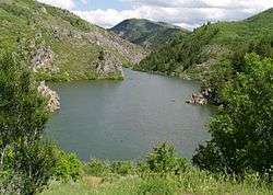
Causey is a 142-acre (0.57 km2) surface area reservoir on the South Fork of the Ogden River. It is a feature of the Weber Basin Project, and lies at an elevation of about 5,700 feet (1,700 m). The reservoir has a maximum depth of 182 feet (55 m) and a mean depth of 65 feet (20 m).[1]
Causey is located in steep, forested, valley terrain, and extends into three canyons.
Management for the reservoir is under jurisdiction of the U.S. Forest Service, Wasatch-Cache National Forest.[2]
History
Causey Dam was constructed between 1962 and 1966 by the Bureau of Reclamation to provide water to the northern Wasatch front area of Utah. It is an earthfill dam.[3]

Activities
Activities at Causey Reservoir include boating and fishing. There are no dedicated boat-launch facilities, and only wake-less speeds are allowed. Fishing includes several trout varieties, including rainbow, cutthroat, and brown.
Swimming and cliff-jumping are also popular.
Camping and picnic sites are available at nearby Memorial Park, and along the Ogden River.
Camp Kiesel, a Boy Scout camp, is located on the northern arm of the reservoir.[4]
References
- ↑ Water Quality report
- ↑ packyourgear.com
- ↑ Bureau of Reclamation (2011-05-18). "Causey Dam". U.S. Department of the Interior. Retrieved 2011-05-18.
- ↑ Water Quality report