Castilla-La Mancha
| Castilla-La Mancha | |||
|---|---|---|---|
| Autonomous community | |||
| |||
.svg.png) Location of Castile-La Mancha within Spain | |||
| Coordinates: 39°52′N 4°01′W / 39.867°N 4.017°WCoordinates: 39°52′N 4°01′W / 39.867°N 4.017°W | |||
| Country | Spain | ||
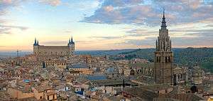
| Capital | Toledo | ||
| Largest city | Albacete | ||
| Provinces | Albacete, Ciudad Real, Cuenca, Guadalajara, Toledo | ||
| Government | |||
| • Type | Devolved government in a constitutional monarchy | ||
| • Body | Cortes of Castilla-La Mancha | ||
| • President | Emiliano García-Page (PSOE) | ||
| Area | |||
| • Total | 79,463 km2 (30,681 sq mi) | ||
| Area rank | 3rd (15.7% of Spain) | ||
| Population (2012) | |||
| • Total | 2,121,888 | ||
| • Rank | 9th (4.3% of Spain) | ||
| • Density | 27/km2 (69/sq mi) | ||
| Demonym(s) | Manchego or Castellano-manchego/a | ||
| Time zone | CET (UTC+1) | ||
| • Summer (DST) | CEST (UTC+2) | ||
| ISO 3166-2 | CM | ||
| Area code | +34 98- | ||
| Statute of Autonomy | 16 August 1982 | ||
| Official languages | Spanish | ||
| Patron saint | Saint George | ||
| Courts | 33 deputies | ||
| Congress | 21 deputies (out of 350)[1] | ||
| Senate | 22 senators (out of 264)[2] | ||
| Website | www.jccm.es | ||

Castilla-La Mancha (English /kæˈstiːjə lɑː ˈmɑːntʃə/; Spanish: [kasˈtiʎa la ˈmantʃa]; sometimes written in English as Castile–La Mancha) is a south-western European region that was part of the Kingdom of Castile. Nowadays it is established as an autonomous community of Spain. Castilla-La Mancha is bordered by Castile and León, Madrid, Aragon, Valencia, Murcia, Andalusia, and Extremadura. It is one of the most sparsely populated of Spain's autonomous communities. Albacete is the largest and most populous city. Its capital city is Toledo, and its judicial capital city is Albacete.
Castilla-La Mancha was formerly grouped with the province of Madrid into New Castile (Castilla la Nueva), but with the advent of the modern Spanish system of autonomous regions (Estado de las autonomías), it was separated due to great demographic disparity between the capital and the remaining New-Castilian provinces. Also, distinct from the former New Castile, Castilla-La Mancha added the province of Albacete, which had been part of Murcia; adding Albacete placed all of the historic region of La Mancha within this single region.
It is mostly in this region where the story of the famous Spanish novel Don Quixote by Miguel de Cervantes is situated, due to which La Mancha is internationally well-known. Although La Mancha is a windswept, battered plateau, it remains a symbol of Spanish culture with its vineyards, sunflowers, mushrooms, olive plantations, windmills, Manchego cheese, and Don Quixote.
History
The history of Castilla-La Mancha has been significant. Its origin lay in the Muslim period between the 8th and 14th century. Castilla-La Mancha was the region of many historical battles between Christian crusaders and Muslim forces during the period from 1000 to the 13th century. It was also the region where the Crown of Castile and Aragon were unified in 1492 under Queen Isabel and King Ferdinand.
Castilla-La Mancha is the successor to New Castile (Castilla la Nueva), which in turn traces back to the Muslim Taifa of Toledo, one of the taifas of Al Andalus. Alfonso VI conquered the region from the Muslims, taking Toledo in 1085. The Reconquista ("Reconquest") took Cuenca in 1177. Other provinces to the south—the Campo de Calatrava, the Valle de Alcudia, and the Alfoz de Alcaraz (Campo de Montiel and Sierra de Alcaraz)—were consolidated during the reign of Alfonso VIII (reigned 1158–1214), whose conquests were completed by the Battle of Las Navas de Tolosa (1212). That victory assured Castilian domination of the region and hastened the decline of the Almohad Dynasty. From the time of the Reconquista, Castilla-La Mancha formed part of the Kingdom of Castile. Four centuries later, in 1605, Cervantes' Don Quixote gave the world an indelible picture of La Mancha.
In 1785, the territorial organization by the reformer Floridablanca divided the region into the provinces of Cuenca, Guadalajara, Madrid, La Mancha, and Toledo. Albacete, Chinchilla, Almansa, Hellín and Yeste, however, became part of Murcia. In 1833 Javier de Burgos modified the provincial borders; most of the province of La Mancha was transferred to the province of Ciudad Real, with smaller parts incorporated into the provinces of Cuenca, Toledo and the newly created province of Albacete. Albacete, in turn, also incorporated parts of the territories of the old provinces of Cuenca and Murcia. Albacete was administered as part of the Region of Murcia until the 1978 configuration of autonomous regions. Nonetheless, during the First Spanish Republic, Albacete was one of the signatories to the Pacto Federal Castellano (1869) and in 1924 its deputation favored the formation of a "Comunidad Manchega" that would have recognized La Mancha (including Albacete) as a region.
The Autonomous Community of Castilla-La Mancha dates from November 15, 1978, as one of the many autonomous regions defined by the Spanish central government. (More precisely, each of these regions was initially a preautonomía, a "pre-autonomous" region, until establishing its Statute of Autonomy). The new, hyphenated name constituted an effort to bridge two distinct regionalisms: that of the larger Castilla (extending beyond this autonomous region) and that of the smaller onetime province of La Mancha. The Statute of Autonomy of Castilla–La Mancha was approved August 10, 1982 and took effect August 17, 1982.[3]
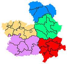
Regional divisions
Castilla-La Mancha is divided into 5 provinces named after their capital cities. The following category includes:
_(3080665244).jpg)
According to the official data of the INE, Castilla-La Mancha consists of 919 municipalities, which amount to 11.3 percent of all the municipalities in Spain. 496 of these have less than 500 inhabitants, 231 have between 501 and 2,000 inhabitants, 157 between 2,000 and 10,000 inhabitants, and only 35 have more than 10,000 inhabitants. The municipalities in the north are small and numerous, while in the south they are larger and fewer. This reflects different histories of how these sub-regions were repopulated during the Reconquista.
The 25 most populous municipalities of Castilla-La Mancha according to the INE are:

| Most populous municipalities of Castilla-La Mancha | |||||||
|---|---|---|---|---|---|---|---|
| Rank | Municipality | Province | Population | ||||
| 1 | Albacete | Albacete | 172,487 | ||||
| 2 | Talavera de la Reina | Toledo | 87,763 | ||||
| 3 | Toledo | Toledo | 84,810 | ||||
| 4 | Guadalajara | Guadalajara | 81,221 | ||||
| 5 | Ciudad Real | Ciudad Real | 72,208 | ||||
| 6 | Cuenca | Cuenca | 54,600 | ||||
| 7 | Puertollano | Ciudad Real | 51,305 | ||||
| 8 | Tomelloso | Ciudad Real | 37,532 | ||||
| 9 | Hellín | Albacete | 31,054 | ||||
| 10 | Azuqueca de Henares | Guadalajara | 30,794 | ||||
| 11 | Alcázar de San Juan | Ciudad Real | 30,408 | ||||
| 12 | Valdepeñas | Ciudad Real | 30,255 | ||||
| 13 | Villarrobledo | Albacete | 26,311 | ||||
| 14 | Almansa | Albacete | 25,591 | ||||
| 15 | Illescas | Toledo | 19,167 | ||||
| 16 | Manzanares | Ciudad Real | 19,027 | ||||
| 17 | Daimiel | Ciudad Real | 18,389 | ||||
| 18 | La Solana | Ciudad Real | 16,392 | ||||
| 19 | La Roda | Albacete | 16,034 | ||||
| 20 | Tarancón | Cuenca | 14,962 | ||||
| 21 | Campo de Criptana | Ciudad Real | 14,870 | ||||
| 22 | Seseña | Toledo | 13,843 | ||||
| 23 | Miguelturra | Ciudad Real | 13,582 | ||||
| 24 | Socuéllamos | Ciudad Real | 13,357 | ||||
| 25 | Torrijos | Toledo | 12,674 | ||||
Comarcas
Although the Statute of Autonomy allows for comarcas of political/juridical significance, this has never been followed through at the level of the entire region, and there are no comarcas in Castilla-La Mancha with political or juridical functions. Individual provinces of Castilla-La Mancha have performed comarcalizations for administrative, economic and touristic purposes. Many Castellano-Manchegan comarcas important traditional significance, with some figuring in history well beyond their respective provinces.

- Comarcas of Albacete:[4]
- Campos de Hellín
- Llanos de Albacete
- La Mancha del Júcar-Centro
- Manchuela albaceteña
- Monte Ibérico–Corredor de Almansa
- Sierra de Alcaraz y Campo de Montiel
- Sierra del Segura
- Comarcas of Ciudad Real:[5]
- Alcudia
- Campo de Calatrava
- Mancha
- Montes
- Montiel
- Sierra Morena
- Comarcas of Cuenca:[6]
- La Alcarria conquense
- La Mancha de Cuenca
- Manchuela conquense
- Serranía Alta
- Serranía Media-Campichuelo
- Serranía Baja

.jpg)
- Comarcas of Guadalajara:[7]
- La Alcarria (comarca)
- La Campiña (comarca)
- Señorío de Molina
- La Serranía
- Comarcas of Toledo:[8]
- La Campana de Oropesa
- La Jara
- La Mancha Alta de Toledo
- Mesa de Ocaña
- Montes de Toledo
- La Sagra
- Sierra de San Vicente
- Talavera (co-extensive with the municipality of Talavera de la Reina).
- Toledo (co-extensive with the municipality of Toledo).
- Torrijos
Official symbols
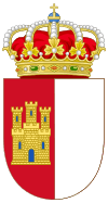
The Organic Law 9/1982 (August 10, 1982), which is the Statute of Autonomy of Castilla-La Mancha established the flag of Castilla-La Mancha and the law 1/1983 (June 30, 1983) established the coat of arms.
Flag
Seven different designs for a flag were proposed during the era of the "pre-autonomous" region. The selected design was that of Manchego heraldist Ramón José Maldonado. This was made official in Article 5 of the Statute of Autonomy:
- One. The flag of the region consists of a rectangle divided vertically into two equal squares: the first, together with the mast, crimson red with a castle of Or masoned in sable and port and windows of azure; the second, white.
- Two. The flag of the region will fly at regional, provincial, or municipal public buildings, and will appear next to the Spanish flag, which will be displayed in the preeminent place; historic territories [provinces] may also be represented.[9]
Coat of arms
The coat of arms of Castilla-La Mancha is based on the flag of the region, and not vice versa, as is more typical in heraldry. Article 1 of the law 1/1983 describes it as follows:
- The coat of arms of the Communities of Castilla-La Mancha is party per pale. On the dexter [the statute literally says "On the first quarter"], on a field gules a castle Or, embattled, port and windows of azure and masoned sable. On the sinister [the statute literally says "The second quarter"], a field argent. On the crest, a royal crown enclosed, which is a circle of Or crimped with precious gems, composed of eight finials, of Acanthus mollis, five visible, topped by pearls and whose leaves emerge from diadems, which converge in a globe of azure or blue, with a semimeridian and the equator Or topped by a cross Or. The crown lined with gules or red.[10]
Some institutions of the region have adopted this coat of arms as part of their own emblem, among these the Cortes of Castilla–La Mancha, the Consultative Council and the University of Castilla-La Mancha.
Anthem
Although Article 5 of the Statute of Autonomy indicates that the region will have its own anthem, after more than 25 years no such anthem has been adopted. Among the proposed anthems have been the "Canción del Sembrador" ("Song of the Sower") from the zarzuela La rosa del azafrán by Jacinto Guerrero, the "Canto a la Mancha" ("Song of La Mancha") by Tomás Barrera, and many others, such as one presented by a group of citizens from Villarrobledo with the title "Patria sin fin" ("Fatherland without end").[11]
Politics and government
Article 8 of the Statute of Autonomy states that the powers of the region are exercised through the Junta of Communities of Castilla-La Mancha (Junta de Comunidades de Castilla-La Mancha). Organs of the Junta are the Cortes of Castilla-La Mancha, the President of the Junta and the Council of Government.
Cortes of Castilla-La Mancha
The Cortes of Castilla-La Mancha represent the popular will through 33 deputies elected by universal adult suffrage through the secret ballot. They are elected for a term of four years under a proportional system intended to guarantee representation to the various territorial zones of Castilla–La Mancha. The electoral constituency is at the level of each province, with provinces being assigned the following number of deputies as of 2009: Albacete, 6; Ciudad Real, 8; Cuenca, 5; Guadalajara, 5; and Toledo, 9. Article 10 of the Statute of Autonomy states that elections will be convoked by the President of the Junta of Communities, following the General Electoral Regime (Régimen Electoral General), on the fourth Sunday in May every four years. This stands in contrast to the autonomous communities of the Basque Country, Catalonia, Galicia, Andalusia and the Valencian Community where the president has the power to convoke elections at any time. (In the Valencian Community that power has never been exercised. Elections there have, in practice, taken place on a four-year cycle.)
Since the Spanish regional elections of 2015, the Cortes of Castilla-La Mancha has consisted of 16 deputies from the conservative People's Party, 15 from the socialist PSOE and 2 from the left-wing Podemos. The Cortes sits in the former Franciscan convent in Toledo, the Edificio de San Gil ("San Gil building").
Council of Government
The Council of Government is the collegial executive organ of the region. It directs regional political and administrative action, exercises an executive function and regulatory powers under the Spanish Constitution of 1978, the Statute of Autonomy, and the laws of the nation and region. The Council of Government consists of the president, vice presidents (if any) and the Councilors.
President of the Junta
The President of the Junta directs the Council of Government and coordinates the functions of its members. The president is elected by the Cortes from among its members, then formally named by the monarch of Spain. The president's official residence is the Palace of Fuensalida in Toledo.
| Presidents of the Junta | |||||||
|---|---|---|---|---|---|---|---|
| Number | Name | Took office | Left office | Party | Notes | ||
| 1. | Antonio Fernández-Galiano Fernández | 1978 | 1982 | UCD | Pre-autonomous president until August 16, 1982. | ||
| 2. | Gonzalo Payo Subiza | 1982 | 1982 | UCD | Pre-autonomous president. He replaced Fernández-Galiano, but left politics the same year. | ||
| 3. | Jesús Fuentes Lázaro | 1982 | 1983 | PSOE | Last pre-autonomous president. | ||
| 4. | José Bono Martínez | 1983 | 2004 | PSOE | First president of the autonomous region. He retained the post until 2004, winning all elections for the position by absolute majority, until he resigned his charge to take on the post of defence minister of Spain. | ||
| 5. | José María Barreda Fontes | 2004 | 2011 | PSOE | Replaced José Bono when the latter resigned to become minister of defense. Elected by an absolute majority after the Spanish regional elections of 2007. | ||
| 6. | María Dolores de Cospedal | 2011 | 2015 | PP | Elected by an absolute majority after the Spanish regional elections of 2011 | ||
| 7. | Emiliano García-Page | 2015 | Incumbent | PSOE | Elected with the support of Podemos after the Spanish regional elections of 2015 | ||
Geography

Castilla-La Mancha is located in the middle of the Iberian peninsula, occupying the greater part of the Submeseta Sur, the vast plain composing the southern part of the Meseta Central. The Submeseta Sur (and the autonomous community) is separated from the Submeseta Norte (and the community of Castilla y León) by the mountain range known as the Sistema Central. Despite this, the region has no shortage of mountain landscapes: the southern slopes of the aforementioned Sistema Central in the north, the Sistema Ibérico in the northeast, and the Sierra Morena and Montes de Toledo in the south.
Castilla-La Mancha is the third largest of Spain's autonomous regions, with a surface area of 79,463 square kilometres (30,681 sq mi), representing 15.7 percent of Spain's national territory.
Terrain
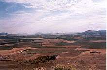

The region has two distinct types of terrain. The Meseta is a vast, uniform plain with little relief. Within that uniformity, the most outstanding variation in altitude is that of the Montes de Toledo, with peaks such as La Villuerca (1,601 meters (5,253 ft)), the highest peak of the Montes de Toledo range, and Rocigalgo (1,447 meters (4,747 ft)). At the south of that system are the Montes de Toledo, which cross the region from west to east, dividing the Tagus (Tajo) and Guadiana drainage basins, forming the southern slope of the basin of the former and the northern slope of the latter.
In contrast, a more mountainous zone surrounds the Meseta and serves as the region's natural border. In the north of the Province of Guadalajara, bordering Madrid and Segovia, is a mountain range forming part of the Sistema Central, among which can be distinguished the mountain ranges Pela, Ayllón, Somosierra, Barahona and Ministra, with the headwaters of the rivers Jarama, Cañamares and Henares. The Sistema Central also penetrates the Province of Toledo, which intersects a southerly part of the Sierra de Gredos, known as the Sierra de San Vicente, delimited on the north by the river Tiétar and on the south by the Alberche and the Tagus.
On the northwest is the Sistema Ibérico, where there is important fluvial and especially karstic activity, which has given rise to such landscapes as the Ciudad Encantada, the Callejones de Las Majadas and the Hoces del Cabriel.
In the southeast is the ridge of the Sierra Morena, the southern border of the Meseta Central and the region's border with Andalusia. Within the Sierra Morena, distinction can be made between the Sierra Madrona, Sierra de Alcudia and Sierra de San Andrés. At the other southern extreme of Castilla–La Mancha, the Sierra de Alcaraz and Sierra del Segura form part of the Sistema Bético.
Hydrography

The territory of Castilla-La Mancha is divided into five principal watersheds. The Tagus, Guadiana, and Guadalquivir drain into the Atlantic Ocean and the Júcar and Segura into the Mediterranean. The Tagus provides water for some 587,000 inhabitants in a watershed of 26,699 square kilometres (10,309 sq mi).[12] It includes the entire province of Guadalajara and the greater part of the province of Toledo, including the two largest cities of the latter province: the capital, Toledo, and the slightly larger city of Talavera de la Reina.
The Guadiana watershed extends 26,646 square kilometres (10,288 sq mi) in Castilla-La Mancha, 37 percent of that river's entire watershed, with a population of 583,259 inhabitants.[13] It includes the southern part of the province of Toledo, nearly all of the province of Ciudad Real (except the very south), the southwest of the province of Cuenca and the northwest of the province of Albacete. The Guadalquivir watershed extends over 5.17 percent[14] of the surface area of the autonomous community, extending 4,100 square kilometres (1,600 sq mi) through the southern parts of the provinces of Ciudad Real and Albacete, including such important population center as Puertollano.[15]
The Júcar watershed had, in 2006, 397,000 inhabitants in an area of 15,737 square kilometres (6,076 sq mi), 19.86 percent of the Castillian-Manchegan territory and 36.61 percent of total of the Júcar watershed.[16] It includes the eastern parts of the provinces of Cuenca and Albacete, including their respective capitals. Finally, the 34 municipalities of southeastern Albacete fall in the Segura watershed, with an extent of 4,713 square kilometres (1,820 sq mi).[17]
Climate

Castilla-La Mancha has a continentalized Mediterranean climate: a Mediterranean climate with a marked character of a continental climate. The continentalized Mediterranean climate is similar to a typical Mediterranean climate, but with more extreme temperatures typical of a continental climate. Lack of a marine influence leads to much more extreme temperatures: hotter summers and quite cold winters, with a daily oscillation of 18.5 °C (33.3 °F). Summer is the driest season, with temperatures often exceeding 30 °C (86 °F), sometimes reaching and exceeding 35 °C (95 °F). In winter, temperatures often drop below 0 °C (32 °F), producing frosts on clear nights, and occasional snow on cloudy nights.
Castilla-La Mancha is part of what has traditionally been called España Seca ("Dry Spain"). It receives relatively little precipitation, much as in a typical Mediterranean climate. Precipitation presents a notable gradient from the center of the region, where it does not surpass 400 millimetres (16 in) per year, to the mountains where it can exceed 1,000 millimetres (39 in) per year, on the slopes of the Sierra de Gredos and the Serranía de Cuenca, as the rain in Spain does not fall mainly in the plains. The greater part of the region has less than 600 millimetres (24 in) of rain annually. The driest part of the region is along the Albacete-Hellín axis, with less than 300 millimetres (12 in) per year.
Demography


Number of inhabitants
According to the official January 11, 2008, data of the INE Castilla-La Mancha has 2,043,100 inhabitants in its five provinces. Despite being the third largest of Spains communities by surface area (after Castilla y León and Andalusia), it is only the ninth most populous. Castilla-La Mancha has just 4.42 percent of Spain's population.
Population density

With an average population density of 25.71 per square kilometre (66.6/sq mi), Castilla-La Mancha has the least dense population in all of Spain: the national average is 88.6 per square kilometre (229/sq mi). Industrialized zones such as the Henares Corridor (along the river Henares, a tributary of the Jarama) with a density of 126 per square kilometre (330/sq mi),[18] the comarca of la Sagra or the industrial zone of Sonseca are dramatically more dense than the region as a whole.
Composition of population by age and sex
The population pyramid of Castilla-La Mancha is typical for a developed region, with the central zone wider than the base or the upper zone. The population between 16 and 44 years of age represents about 44 percent, from 45 to 64 about 21.3 percent, with those 15 and under constituting 15 percent and those over 65, 18 percent. These data show the progressive aging of the castellano-manchego population.
The region has about 9,000 more males than females; in percentage terms, 50.25 percent versus 49.75 percent. This is opposite to Spain as a whole, where women constitute 50.57 percent of the population.
Birth rate, death rate, life expectancy
According to 2006 INE numbers, the birth rate in Castilla-La Mancha is 10.21 per thousand inhabitants, lower than the national average of 10.92 per thousand. The death rate is 8.83 per thousand inhabitants, higher than the national average of 8.42 per thousand.
Life expectancy at birth is one of the highest in Spain: 83.67 years for women and 77.99 years for men.
| Castilla-La Mancha population 1900–2000 (in thousands) |
|---|
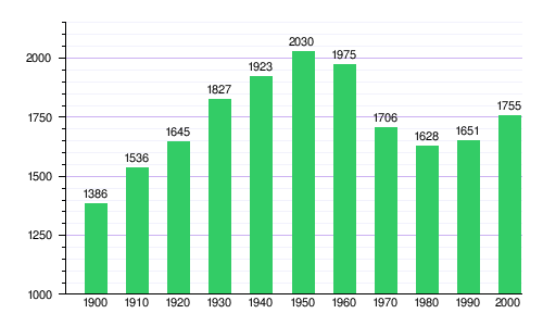 |
| Smallest unit: 20,000 people. |
| Source: Instituto Nacional de Estadística de España |
| Graphic elaborated by: Wikipedia |
Transportation
Highways
Castilla-La Mancha has the most kilometers of autopistas (a type of limited access highway) and autovías dual carriageways, with a total of 2,790 kilometres (1,730 mi).[19] The most heavily trafficked of these are the radial routes surrounding Madrid and the routes in and out of the city, but there are also routes within Castilla-La Mancha, and national and international routes that pass through the province, including highways in the International E-road network.
The regional government put into action a Plan Regional de Autovías with the objective that all municipalities with 10,000 or more inhabitants would be connected to an autovía. If it is completed, 96 percent of the region's population will live within 15 minutes of a high-capacity road.[20] Among the developed projects of this plan are:
- Autovía de los Viñedos, 127 kilometres (79 mi) connecting Toledo and Tomelloso (completely in service).
- Autovía de la Sagra, 85 kilometres (53 mi) connecting the Autovía A-5 with the Autovía A-4 (Tranches I and II under way, duplication of highway CM-4001 in the tendering of works phase).
- Autovía del IV Centenario, 142 kilometres (88 mi) departs Ciudad Real to meet with the future Autovía Linares-Albacete (A-32), passing through Valdepeñas (first phase partially under way, second currently being studied).
- Autovía del Júcar, 130 kilometres (81 mi), will connect Albacete to Cuenca (in project).
- Autovía de la Alcarria: although initially contemplated in the Plan Regional de Autovías, the Ministry of Development has taken over the work. It will connect the Autovía del Este (Autovía A-4) with the Autovía del Nordeste (Autovía A-2) (currently being studied).
The red autonómica—the road network of the autonomous community—currently extends 7,900 kilometres (4,900 mi), of which 1,836 kilometres (1,141 mi) correspond to the basic network, 5,314 kilometres (3,302 mi) to the comarcal networks and 750 kilometres (470 mi) to local networks.
| Name | From/To | Important cities in Castilla-La Mancha on route |
|---|---|---|
| | Linares - Albacete | Albacete |
| | Ávila - Cuenca | Torrijos, Toledo, Ocaña, Tarancón, Cuenca |
| | Mérida - Atalaya del Cañavate | Ciudad Real, Almadén, Daimiel, Manzanares, Argamasilla de Alba, Tomelloso, San Clemente, Villarrobledo |
| Autovía de la Alcarria | Guadalajara - Tarancón | Guadalajara, Mondéjar, Tarancón |
| | A-5 - A-4 | Valmojado, Illescas, Borox, Añover de Tajo |
| | Manzanares - La Solana | Manzanares, La Solana |
| | Ciudad Real - Valdepeñas | Ciudad Real, Almagro, Valdepeñas |
| Autovía del Júcar | Albacete - Cuenca | Cuenca, Motilla del Palancar, Villanueva de la Jara, Quintanar del Rey, Tarazona de la Mancha, Madrigueras, Albacete |
| Autovía Transmanchega | Daimiel - Tarancón | Daimiel, Villarrubia de los Ojos, Alcázar de San Juan, Quintanar de la Orden, Villamayor de Santiago, Horcajo de Santiago, Tarancón |
| Ronda Suroeste de Toledo | CM-42 - A-40 | Burguillos de Toledo, Cobisa, Argés, Bargas |
| Ronda Este de Toledo | CM-42 - A-40 | Toledo |
Railways
RENFE, Spain's state-owned national passenger railway network has numerous lines and stations throughout Castilla-La Mancha.
Long distance
Numerous long distance rail lines (líneas de largo recorrido) pass through Castilla-La Mancha, most of them radiating out of Madrid. Some of these are high-velocity trains (Alta Velocidad Española AVE):[21]
- Normal Largo Recorrido trains
- Alicante - Albacete - Alcázar de San Juan - Ciudad Real
- Madrid - Ciudad Real - Jaén
- Madrid - Ciudad Real - Badajoz
- Madrid - Cuenca - Valencia
- Madrid - Guadalajara - Soria
- Madrid - Guadalajara - Arcos de Jalón
- Madrid - Talavera de la Reina - Badajoz
- High velocity AVE trains
- Madrid - Ciudad Real - Puertollano - Córdoba - Seville).
- Madrid - Toledo
- Madrid - Guadalajara - Zaragoza - Barcelona.
- Madrid - Cuenca - Albacete - Valencia (in project).
- Madrid - Toledo (La Sagra) - Talavera de la Reina - Navalmoral de la Mata - Plasencia - Fuentidueñas - Cáceres - Mérida - Badajoz - Lisbon (in project).
Local trains
Two local commuter rail lines out of Madrid (Cercanías Madrid) pass through Castilla-La Mancha. The C-2 line stops in Azuqueca de Henares in the province of Guadalajara and in the city of Guadalajara itself. The C-3 to Aranjuez used to stop at Seseña, but service to that station was discontinued in April 2007.
Airports
As of 2009, Castilla-La Mancha had two airports.
The Albacete Airport is 4 kilometres (2.5 mi) south of Albacete, connected by the CM-3203 highway. It has been a civilian airport since July 1, 2003, sharing facilities with the military airbase of Los Llanos. The Ciudad Real Central Airport is located between Ciudad Real and Puertollano and is Spain's largest private airport. Located adjacent to the A-43 highway (Autovía Extremadura-Comunidad Valenciana) and a short distance from the AP-41 toll highway (Autovía Ciudad Real - Puertollano)
Residents of some Madrid exurbs have easy access to Barajas Airport in northeast Madrid, as well.
Economy
The economy of Castilla-La Mancha continues to be dominated by agriculture and the raising of livestock, but industry is continually more present, including the processing of agricultural goods. In recent years, tourism has been increasingly important, with the growth of agritourism in the form of casas rurales, and the establishment of the Ruta de Don Quijote, a campaign of tourism to the locations mentioned in Cervantes novel.
Economic data
Gross domestic product

Castilla-La Mancha generates a GDP of €33,077,484,000, 3.4 percent of the Spanish GDP, placing it ninth among the 19 Spanish autonomous communities. GDP has been roughly 3.4 percent of the national GDP since at least 2000. A per capita GDP of €17,339 places Castilla-La Mancha 17th among the 19 communities, with only Andalusia and Extremadura having lower per capita GDP; the national average is €22,152. Nonetheless, in the early to mid-1990s, Sonseca in the province of Toledo several times had the highest per capita income in Spain.
In 2005 the Manchego GDP broke down by productive sectors as follows:[22]
- Agriculture 11.64%
- Industry 14.95%
- Energy 3.44%
- Construction 10.06%
- Services 49.78%
Work force
According to the statistics of the INE's Encuesta de Población Activa for the first trimester of 2007, the active work force of Castilla-La Mancha numbered 896,513 persons, of whom 827,113 were employed and 69,900 unemployed, giving a workforce density of 55.5 percent of the population and an unemployment rate of 7.68 percent.
Economic sectors
As noted above, for statistical purposes the economy of Castilla-La Mancha is divided into agriculture (including livestock husbandry), industry (including agro-industry), energy, construction, and services (including tourism).
Agriculture and husbandry


Agriculture and husbandry, still the foundation of the local economy, constitutes 11.64 percent of regional GDP, and employs 9.9 percent of the active workforce.
Fifty-two percent of the soil of Castilla-La Mancha is considered "dry". Agricultural activities have historically been based on the cultivation of wheat (37 percent), grapes (17.2 percent) and olives (6.6 percent). Castilla-La Mancha has some of the most extensive vineyards in Europe, nearly 700,000 hectares (1,700,000 acres). The vineyards are predominantly, but by no means exclusively, in the west and southwest of La Mancha. In 2005 the region produced 3,074,462 metric tons (3,389,014 short tons) of grapes, constituting 53.40 percent of Spain's national production. After grapes, the next most important agricultural product is barley, 2,272,007 metric tons (2,504,459 short tons), 25 percent of the national total.
In terms of agricultural productivity and income, since Spain's incorporation into the European Union (EU) the primary sector of the regional economy has evolved dynamically. Among the reasons for this are growth rates higher than the national average, as well as increased capitalization fostering specialization and modernization, including the integration an externalization of the sector, whereby activities previously performed on the farm are now performed elsewhere. These changes have been fostered by the regional articulation of the EU's Common Agricultural Policy. Since 1986, subsidies have played a significant role in this sector.
Animal husbandry plays a lesser, but not negiglible, role in the regional economy. 2005 statistics show 3,430,501 head of sheep, 1,602,576 pigs, 405,778 goats and 309,672 cattle; these last produce 224,692,000 liters (59,357,000 U.S. gal) of milk each year. Apiculture (bee-keeping) is also important, with 180,000 hives.
Industry and construction

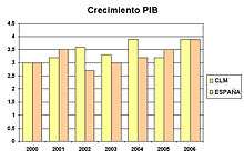
Traditionally, Castilla-La Mancha has had little industrial production, due to several factors among which are low population density and a shortage of qualified workers. However, since Spain's incorporation into the EU, there has been much progress. Industry has been growing as a sector of the Manchego economy at a faster pace than nationally. July 2006 figures show the region as third among the autonomous communities in the rate of growth of the industrial sector. Regional industrial GDP grew 2.8 percent in 2000-2005, compared to 1 percent nationally for the same period.
The greatest obstacles to industrial growth in the region have been:[23]
- Lack of a dense business fabric.
- Undersized industrial enterprises.
- Little specialization of labor.
- Little investment in R & D.
- Poor infrastructure with respect to services to enterprises.
- Little export orientation.
- Inadequate marketing channels and distribution for regional products.
The principal industrial areas within the region are Sonseca and its comarca, the Henares Corridor, Puertollano, Talavera de la Reina, La Sagra y Almansa, as well as all of the provincial capitals.
As throughout Spain in recent decades, the construction sector is one of the strongest. It employs 15.6 percent of the work force and produces 10.06 percent of regional GDP. It is one of the fastest-growing sectors of the economy: growth in 2006 was 13.6 percent. Most of the construction sector, is housing, including a new city of 30,000 inhabitants, Ciudad Valdeluz in Yebes, Guadalajara; 13,000 dwellings in Seseña, Toledo and the Reino de Don Quijote complex in the province of Ciudad Real, with 9,000 dwellings and 4,000 hotel beds.
Energy
Although wind energy and solar energy have been playing increasingly important roles in Castilla–La Mancha, the majority of the energy generated in the region comes from the region's large thermal power stations:
| Nombre | Locale | Province | Proprietor |
|---|---|---|---|
| Elcogas Thermal Power Station | Puertollano | Ciudad Real | Elcogas[24] |
| Puertollano Thermal Power Station | Puertollano | Ciudad Real | E.ON |
| Aceca Thermal Power Station | Villaseca de la Sagra | Toledo | Iberdrola and Unión Fenosa[25] |
Castilla-La Mancha is also the home of the Trillo Nuclear Power Plant near Trillo, Guadalajara.
As of 2009, thermosolar plants are under development in Puertollano (being built by Iberdrola Renovables, as well as two more in Cinco Casas, province of Ciudad Real (called Manchasol, being built by Grupo ACS) .
Service sector
The majority of the Manchego workforce—55.5 percent—is employed in the service sector, generating 49.78 percent of regional GDP, according to Economic and Social Council of Castilla-La Mancha (Consejo Económico y Social de Castilla-La Mancha, CES) data for 2006. Although a large sector of the Manchego economy, it is small by national standards: 67.2 percent of employment in Spain is in the service sector.[26] Counted in the service sector are commerce, tourism, hospitality, finance, public administration, and administration of other services related to culture and leisure.
In the area of tourism, there has been a great deal of growth, with Castilla-La Mancha becoming in recent decades one of the principal tourist destinations in the Spanish interior. During 2006 the region had more than 2 million tourists (3 percent more than the previous year) for a total of 3,500,000 overnight hotel stays. Rural tourism increased 14 percent in overnight stays in a single year. From 2000 to 2005 the number of hotel beds increased 26.4 percent to 17,245 beds in 254 hotels. In the same period, the number of casas rurales (for farm stays) increased 148 percent to 837 and the number of beds in such facilities 175 percent to 5,751.[27]
Health
The Servicio de Salud de Castilla-La Mancha (SESCAM, "Health Service of Castilla–La Mancha"), part of the Consejería de Salud y Bienestar Social ("Council of Health and Social Welfare") is the entity in charge of health in Castilla–La Mancha. It is an integral part of Spain's National Health System, based on universal coverage, equal access, and public financing.
Education
The Junta of Castilla-La Mancha assumed responsibility for education in the autonomous community as of January 1, 2000, directly managing over 1,000 schools, with 22,000 teachers and 318,000 students.[28] In the 2006–2007 school year, the region had 324,904 students below the university level, of whom 17.7 percent were in private schools.[29] In that same year, the region had 1,037 schools[30] and 30,172 schoolteachers;[31] 15.21 percent of the schools were private.[30]
The decentralized University of Castilla-La Mancha was formally established in 1982 and has operated since 1985. There are four main campuses, one each at Albacete, Ciudad Real, Cuenca and Toledo, with classes also offered in Almadén, Talavera de la Reina and Puertollano. The university offers 54 degree programs (titulaciones). The province of Guadalajara stands outside the regional university, with its own University of Alcalá offering degrees in education, business, tourism, technical architecture, and nursing. The National University of Distance Education also offers services in the region through five affiliated centers, one in each province: Albacete (with an extension in Almansa), Valdepeñas, Cuenca, Guadalajara, and Talavera de la Reina. Finally, the Menéndez Pelayo International University has a location in Cuenca.
In the 2005–06 school year, the region had 30,632 students enrolled at universities, down 1.01 percent from the previous year.[32]
Historically, the region has had other universities, but these no longer exist. The present University of Castilla-La Mancha uses one of the buildings of the Royal University of Toledo (1485–1807). Other former universities in the region were the Royal and Pontifical University of Our Lady of Rosario in Almagro (1550–1807) and the University of San Antonio de Porta Coeli in Sigüenza founded in the 15th century by Cardinal Pedro González de Mendoza and, like the others, closed in the Napoleonic era.
List of cathedrals in Castilla-La Mancha
List of castles in Castilla-La Mancha

These are some castles of Castilla-La Mancha:
See also
- List of Presidents of the Cortes of Castilla-La Mancha
- Castile (historical region)
- Crown of Castile
- Manchego cuisine
References

- ↑ 4 from province of Albacete, 5 from Ciudad Real, 3 from Cuenca, 3 from Guadalajara and 6 from Toledo.
- ↑ 20 are directly elected by the people, each province forms a constituency and is granted 4 senators, and 2 regional legislature-appointed senators.
- ↑ The statute is L.O. [ley orgánica, "organic law"] 9/1982
- ↑ "Comarcas de Albacete. Diputación Provincial de Albacete". Retrieved 2008-05-12.
- ↑ "Comarcas de Ciudad Real. Diputación Provincial de Ciudad Real". Retrieved 2008-10-26.
- ↑ "Municipios de Cuenca. Diputación Provincial de Cuenca". Retrieved 2008-05-12.
- ↑ "Comarcas de Guadalajara. Diputación Provincial de Guadalajara". Archived from the original on 2008-04-19. Retrieved 2008-05-12.
- ↑ "Diputación provincial de Toledo". Retrieved 2007-06-26.
- ↑ "La bandera". Retrieved 17 November 2009.
Estatuto de Autonomía de Castilla-La Mancha, Artículo quinto.
- Uno. La bandera de la región se compone de un rectángulo dividido verticalmente en dos cuadrados iguales: el primero, junto al mástil, de color rojo carmesí con un castillo de oro mazonado de sable y aclarado de azur y el segundo, blanco.
- Dos. La bandera de la región ondeará en los edificios públicos de titularidad regional, provincial o municipal, y figurará al lado de la bandera de España, que ostentará lugar preeminente; también podrá figurar la representativa de los territorios históricos. line feed character in
|quote=at position 62 (help)
- ↑ "El Escudo de Castilla-La Mancha". Archived from the original on 20 July 2011. Retrieved 17 November 2009.
Article 1 of the law 1/1983:
- El escudo de la Junta de Comunidades de Castilla-La Mancha es partido. En el primer cuartel, en campo de gules un castillo de oro almenado, aclarado de azur y mazonado de sable. El segundo cuartel, campo de argento plata. Al timbre, corona real cerrada, que es un círculo de oro engastado de piedras preciosas, compuesto de ocho florones, de hojas de acanto, visibles cinco, interpolado de perlas y de cuyas hojas salen sendas diademas sumadas de perlas, que convergen en un mundo de azur o azul, con el semimeridiano y el ecuador de oro sumado de cruz de oro. La corona forrada de gules o rojo. line feed character in
|quote=at position 29 (help)
- El escudo de la Junta de Comunidades de Castilla-La Mancha es partido. En el primer cuartel, en campo de gules un castillo de oro almenado, aclarado de azur y mazonado de sable. El segundo cuartel, campo de argento plata. Al timbre, corona real cerrada, que es un círculo de oro engastado de piedras preciosas, compuesto de ocho florones, de hojas de acanto, visibles cinco, interpolado de perlas y de cuyas hojas salen sendas diademas sumadas de perlas, que convergen en un mundo de azur o azul, con el semimeridiano y el ecuador de oro sumado de cruz de oro. La corona forrada de gules o rojo. line feed character in
- ↑ "Himno de Castilla-La Mancha". Retrieved 2008-05-12.
- ↑ "Distribución territorial y de la población por CC.AA. de la Cuenca Hidrográfica del Tajo". Archived from the original on 2008-05-12. Retrieved 2008-05-12.
- ↑ "La gestión del agua en Castilla-La Mancha" (PDF). Retrieved 2008-05-12.
- ↑ "Distribución Territorial de la Cuenca Hidrográfica del Guadalquivir". Archived from the original on 2008-04-14. Retrieved 2008-05-12.
- ↑ "¿Quién debe gestionar los ríos?". Retrieved 2008-05-12.
- ↑ "Confederación Hidrográfica del Júcar". Retrieved 2008-05-12.
- ↑ "Distribución Territorial de la Cuenca Hidrográfica del Segura". Retrieved 2008-05-12.
- ↑ "Alcaldes del corredor del Henares conocerán el jueves el texto inicial del plan de ordenación". Archived from the original on 2008-03-09. Retrieved 2008-05-12.
- ↑ "Castilla-La Mancha, la Comunidad Autónoma con más kilómetros de autovías de España". Archived from the original on 2008-02-29. Retrieved 2008-05-12.
- ↑ "Plan Regional de Autovías". Archived from the original on 2008-05-07. Retrieved 2008-05-12.
- ↑ "Renfe Media Distancia en Castilla-La Mancha". Retrieved 2008-05-12.
- ↑ "Consejo Económico y Social de Castilla-La Mancha (Producción y sectores productivos)" (PDF). Retrieved 2008-05-12.
- ↑ "Pacto por el Desarrollo y la Competitividad en Castilla-La Mancha" (PDF). Archived from the original (PDF) on 2007-09-28. Retrieved 2008-05-12.
- ↑ CSIC: Las escorias de la central térmica GICC ELCOGAS como materia prima.
- ↑ JCCM: Visita a la central térmica de ciclo combinado de Aceca (Toledo).
- ↑ "El sector servicios. Panorámica de su estructura y características" (PDF). Retrieved 2008-05-12.
- ↑ "Plan de Ordenación y Promoción del Turismo en Castilla-La Mancha". Archived from the original on 2008-04-16. Retrieved 2008-05-12.
- ↑ "La educación en Castilla-La Mancha". Archived from the original on 2008-02-28. Retrieved 2009-05-12.
- ↑ "Instituto de Estadística de CLM. Total matriculados por provincia y enseñanza. Curso 2006-2007". 2008-05-12.
- 1 2 "Instituto de Estadística de CLM. Clasificación de los centros por tipo, provincia y enseñanza que imparten". Retrieved 2009-05-12.
- ↑ "Instituto de Estadística de CLM. Profesorado por provincia y tipo de centro". Retrieved 2008-05-12.
- ↑ "Instituto de Estadística de CLM. Alumnado matriculado en educación universitaria por CC.AA. y tipo de estudio". Retrieved 2008-05-12.
External links
| Wikimedia Commons has media related to Castile-La_Mancha. |
| Wikisource has original text related to this article: |
- Official Web Site of Castile-La Mancha
- Government of Castile-La Mancha
- Statistics Institute of Castile-La Mancha
- University of Castilla-La Mancha
- Regional Meteorological Institute of Castile-La Mancha
- Innovation in Castile-La Mancha Web Site
- Castile-La Mancha on About-Spain.net
- Surface area of municipalities in Castile-La Mancha
Provinces of Castilla–La Mancha | |||
|---|---|---|---|