Castignano
| Castignano | |
|---|---|
| Comune | |
| Comune di Castignano | |
|
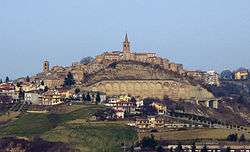
View from Ripaberarda | |
 Castignano Location of Castignano in Italy | |
| Coordinates: 42°56′N 13°37′E / 42.933°N 13.617°ECoordinates: 42°56′N 13°37′E / 42.933°N 13.617°E | |
| Country | Italy |
| Region | Marche |
| Province / Metropolitan city | Province of Ascoli Piceno (AP) |
| Frazioni | Ripaberarda, San Venanzo, San Martino, Castiglioni, Rufiano, Sant'Angelo di Ripaberarda |
| Area | |
| • Total | 38.9 km2 (15.0 sq mi) |
| Elevation | 473 m (1,552 ft) |
| Population (Dec. 2004) | |
| • Total | 3,039 |
| • Density | 78/km2 (200/sq mi) |
| Demonym(s) | Castignanesi |
| Time zone | CET (UTC+1) |
| • Summer (DST) | CEST (UTC+2) |
| Postal code | 63072 |
| Dialing code | 0736 |
| Website | Official website |
Castignano is a comune (municipality) in the Province of Ascoli Piceno in the Italian region Marche, located about 80 kilometres (50 mi) south of Ancona and about 10 kilometres (6 mi) northeast of Ascoli Piceno. As of 31 December 2004, it had a population of 3,039 and an area of 38.9 square kilometres (15.0 sq mi).[1]
The municipality of Castignano contains the frazioni (subdivisions, mainly villages and hamlets) Ripaberarda, San Venanzo, San Martino, Castiglioni, Rufiano, and Sant'Angelo di Ripaberarda.
Castignano borders the following municipalities: Appignano del Tronto, Ascoli Piceno, Cossignano, Montalto delle Marche, Montedinove, Offida, Rotella.
Among its churches are the Sanctuary of San Bernardino da Siena and Santi Pietro e Paolo.
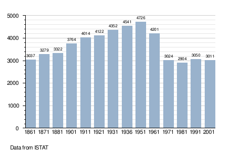
Demographic evolution