Castiglione d'Orcia
| Castiglione d'Orcia | ||
|---|---|---|
| Comune | ||
| Comune di Castiglione d'Orcia | ||
 | ||
| ||
 Castiglione d'Orcia Location of Castiglione d'Orcia in Italy | ||
| Coordinates: 43°1′N 11°37′E / 43.017°N 11.617°ECoordinates: 43°1′N 11°37′E / 43.017°N 11.617°E | ||
| Country | Italy | |
| Region | Tuscany | |
| Province / Metropolitan city | Siena (SI) | |
| Frazioni | Bagni San Filippo, Belvedere, Campiglia d'Orcia, Masse, Montieri, Osteria Gallina, Ripa, Rocca d'Orcia, Vivo d'Orcia | |
| Government | ||
| • Mayor | Fabio Savelli | |
| Area | ||
| • Total | 141.7 km2 (54.7 sq mi) | |
| Elevation | 540 m (1,770 ft) | |
| Population (31 December 2004)[1] | ||
| • Total | 2,530 | |
| • Density | 18/km2 (46/sq mi) | |
| Demonym(s) | Castiglionesi | |
| Time zone | CET (UTC+1) | |
| • Summer (DST) | CEST (UTC+2) | |
| Postal code | 53023 | |
| Dialing code | 0577 | |
| Website |
www | |
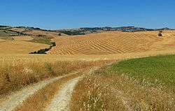
Castiglione d'Orcia is a comune (municipality) in the Province of Siena in the Italian region of Tuscany, located about 90 kilometres (56 mi) southeast of Florence and about 40 kilometres (25 mi) southeast of Siena, in the Val d'Orcia, not far from the Via Cassia.
Castiglione d'Orcia borders the following municipalities: Abbadia San Salvatore, Castel del Piano, Montalcino, Pienza, Radicofani, San Quirico d'Orcia, Seggiano.
History
The settlement is mentioned for the first time in 714, when it was a possession of the Aldobrandeschi family. In 1252 it became a free commune, but lost its independence in the following century to the Republic of Siena, which entrusted it to powerful families like the Piccolomini and Salimbeni. Later, Castiglione was part of the Grand Duchy of Tuscany and, from 1861, of unified Italy.
Main sights
- Rocca (Castle) of Tentennano, overlooking the frazione of Rocca d'Orcia. It was the centre of the struggle between the Salimbeni and the Republic of Siena, which re-acquired it in 1408. In the 16th century it was again contended between Siena and Florence
- Rocca Aldobrandesca.
- Romanesque churches of Santa Maria Maddalena and Santi Stefano and Degna. The latter houses a Madonna with Child by Simone Martini and a Madonna with Child by Pietro Lorenzetti.
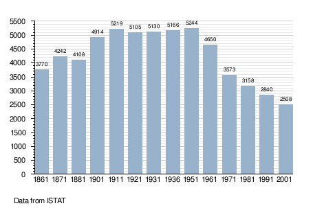
Demographic evolution
References
External links
| Wikimedia Commons has media related to Castiglione d'Orcia. |