Castel di Lama
| Castel di Lama | |
|---|---|
| Comune | |
| Comune di Castel di Lama | |
 Castel di Lama Location of Castel di Lama in Italy | |
| Coordinates: 42°52′N 13°42′E / 42.867°N 13.700°ECoordinates: 42°52′N 13°42′E / 42.867°N 13.700°E | |
| Country | Italy |
| Region | Marche |
| Province / Metropolitan city | Province of Ascoli Piceno (AP) |
| Frazioni | Villa S. Antonio, Villa Chiarini, Villa Cese |
| Area | |
| • Total | 11.0 km2 (4.2 sq mi) |
| Population (Dec. 2004) | |
| • Total | 7,568 |
| • Density | 690/km2 (1,800/sq mi) |
| Demonym(s) | Lamensi |
| Time zone | CET (UTC+1) |
| • Summer (DST) | CEST (UTC+2) |
| Postal code | 63030 |
| Dialing code | 0736 |
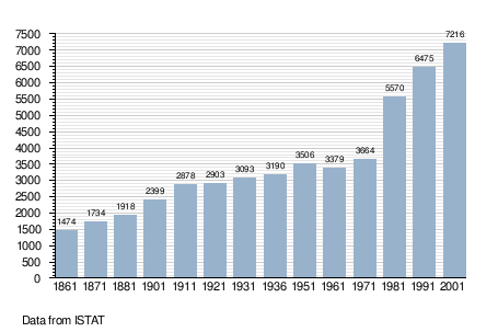
Castel di Lama is a comune (municipality) in the Province of Ascoli Piceno in the Italian region Marche, located about 80 kilometres (50 mi) south of Ancona and about 10 kilometres (6 mi) east of Ascoli Piceno. As of 31 December 2004, it had a population of 7,568 and an area of 11.0 square kilometres (4.2 sq mi).[1]
The municipality of Castel di Lama contains the frazioni (subdivisions, mainly villages and hamlets) Villa S. Antonio, Villa Chiarini, and Villa Cese.
Castel di Lama borders the following municipalities: Appignano del Tronto, Ascoli Piceno, Castorano, Offida.
The name comes from a mediaeval castle on the hill, which is now the hotel Borgo Storico Seghetti Panichi.
Demographic evolution
References
This article is issued from Wikipedia - version of the 1/31/2015. The text is available under the Creative Commons Attribution/Share Alike but additional terms may apply for the media files.