Cascadia State Park
| Cascadia State Park | |
|---|---|
|
Park entrance | |
 | |
| Type | Public, state |
| Location | Linn County, Oregon |
| Nearest city | Cascadia |
| Coordinates | 44°23′53″N 122°28′22″W / 44.398181°N 122.4728589°WCoordinates: 44°23′53″N 122°28′22″W / 44.398181°N 122.4728589°W[1] |
| Operated by | Oregon Parks and Recreation Department |

Cascadia State Park is a state park in the U.S. state of Oregon near Sweet Home along the South Santiam River at Cascadia. The park includes a day use area, campsites, hiking trails and 150 foot Lower Soda Creek Falls.[2]
History
Prior to settlers arriving, groups from the Molalla and Kalapuya tribes visited the park site to harvest huckleberries, fish and hunt. Cascadia Cave is nearby. The cave is an 8,000-year-old American Indian petroglyph site considered to have the largest concentration of rock engravings in western Oregon.[3]
Willamette Valley settlers developed a bypass at the park site for horse-drawn wagons. Old wagon ruts are still visible near where Soda Creek meets the South Santiam River.[2]
In 1896, George Geisendorfer opened a resort to capitalize on what he called the "curative powers" of Soda Creek's mineral spring water. The resort included a hotel, tennis courts, croquet course, garden and bowling alley.[4] The hotel later burned and the property was acquired by the state of Oregon in 1940.[5]
Hiking trails
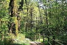
Cascadia State Park includes two primary hiking trails. The one mile Soda Creek Falls Trail follows Soda Creek to Lower Soda Creek Falls. The 3/4 mile loop River Trail descends to the South Santiam River.[2]
Flora

A forest canopy of Douglas-Fir, cedar and hemlock shades the ground, encouraging the growth of ferns, mosses and mushroom species. Wildflowers include Oregon trout lily, fairy slipper, western trillium, camas, fawn lily, Hooker’s fairy bells, snow queen, false Solomon’s-seal, stream violet, Oregon Iris and Pacific bleeding heart.[2]
Access
The park is located along U.S. Highway 20 14 miles east of Sweet Home and 59 miles west of Sisters.
Gallery
-
_(linnDA0067b).jpg)
Autumn colors at Cascadia State Park on the South Santiam River.
-
_(linnDA0065).jpg)
The South Santiam River at Cascadia State Park.
-
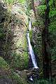
Soda Creek Falls at Cascadia State Park.
See also
References
- ↑ "Cascadia State Park". Geographic Names Information System. United States Geological Survey. Retrieved 2011-06-21.
- 1 2 3 4 "Cascadia State Park Brochure" (PDF). Oregon Parks and Recreation Department. Retrieved 2012-05-19.
- ↑ "Over the Rivers Through the Woods Scenic Byway Tour". Willamette National Forest, United States Department of Agriculture. 2009-04-23. Retrieved 2012-05-19.
- ↑ "Rangers Pick -- Cascadia State Park". Oregon Parks and Recreation Department. 2010-06-09. Retrieved 2012-05-19.
- ↑ "Rails and Roads in the Upper Santiam". Benton County Historical Society and Museum. Archived from the original on 2010-12-13. Retrieved 2012-05-19.
External links
- "Cascadia State Park". Oregon Parks and Recreation Department. Retrieved 2011-06-21.
- Cascadia State Park Brochure