Carterton Railway Station
Carterton | ||||||||||||||||
|---|---|---|---|---|---|---|---|---|---|---|---|---|---|---|---|---|
| Metlink regional rail | ||||||||||||||||
 | ||||||||||||||||
| Location | Wheatstone Street, Carterton, New Zealand | |||||||||||||||
| Coordinates | 41°1′18″S 175°31′23.89″E / 41.02167°S 175.5233028°E | |||||||||||||||
| Elevation | 78 metres (256 ft) | |||||||||||||||
| Owned by | Greater Wellington Regional Council | |||||||||||||||
| Operated by | Wairarapa Railway Restoration Society (lessee) | |||||||||||||||
| Line(s) | Wairarapa Line | |||||||||||||||
| Distance | 76.6 kilometres (47.6 mi) from Wellington | |||||||||||||||
| Platforms | Single side | |||||||||||||||
| Tracks |
| |||||||||||||||
| Train operators | Tranz Metro | |||||||||||||||
| Construction | ||||||||||||||||
| Structure type | at-grade | |||||||||||||||
| Parking | Yes | |||||||||||||||
| Bicycle facilities | Yes, limited | |||||||||||||||
| Architectural style | "Vogel era" Special Class (gable) | |||||||||||||||
| Other information | ||||||||||||||||
| Station code | CART | |||||||||||||||
| Fare zone | 13[1] | |||||||||||||||
| History | ||||||||||||||||
| Opened | 1 November 1880 | |||||||||||||||
| Closed | 13 October 1986 (freight) | |||||||||||||||
| Traffic | ||||||||||||||||
| Passengers (2012) | >358 passengers/day[2] | |||||||||||||||
| Services | ||||||||||||||||
| ||||||||||||||||
Carterton railway station is a suburban railway station serving Carterton, New Zealand. The station is located on the Wairarapa Line, 76.6 km (47.6 mi) north of Wellington and 14.4 km (8.9 mi) south of Masterton. The Wairarapa Connection serves the station several times daily with services to Wellington and Masterton. The station has a single seven-car side platform.
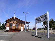
This station retains its original station building (built in 1879-80), freight yard and loading bank, though freight is no longer accepted. A ticket office operates in the station building prior to the departure of commuter trains bound for Wellington. Heritage rolling stock is stored in the yard.
The Carterton Railway Museum, operated from the station building by the Wairarapa Railway Restoration Society, is open every Sunday between 10am and 4pm.
History
Construction of buildings for use by railway staff and the station itself was underway in May 1880, with the station master’s house (used initially as the resident engineer’s office), followed a month or two later by the station building.
The first train to depart was a special goods train carrying a load of timber, on 5 July 1880. It was another three months before goods consignments were accepted, on 11 October 1880, with the first goods train running to Masterton two days later. The first passenger train ran on 30 October 1880. The line between Woodside and Masterton was officially opened on 1 November 1880.
In 1884 Carterton was recorded as having a five-room station building with a 60-by-30-foot (18.3 by 9.1 m) goods shed and watering facilities. Cattle and sheep yards and a loading bank were installed prior to 1890. There were three loops, holding 56, 23, and 9 wagons; a goods shed road holding 9; and a siding behind it with capacity of 32. In 1884 the station sold 6,530 passenger tickets, and handled 13,610 tons of goods outward and 1,583 tons inward and 20,875 head of livestock, mostly sheep and mostly outward.
Carterton was a manned station until 1989 when the last staff positions were withdrawn. This move led to a decline in the condition of the station buildings, a situation which in part prompted the formation of the Wairarapa Railway Restoration Society. The goods shed and some unused track which was used for marshalling purposes were removed in the late 1980s.
The Society has saved the Waingawa station building in the early 1990s, it is now located beside the loading bank in the Carterton Station Yard.
Services
There are five Wairarapa Connection trains each way Monday to Thursday, six Friday and two Saturday and Sunday. There are occasional excursions, such as the Daffodil Express and the Tararua Tourer run by Mainline Steam.
Gallery
 Station from yard, 2006.
 Four-wheel goods van and stock wagon, 2006
 Heritage rolling stock, 2006
 Platform looking north-east, 2006
 Platform looking south-west, 2006
 Loading Bank, 2006
 Waingawa Railway Station, beside Loading Bank, 2006
 Museum and Restoration Society sign as viewed 2006
 Museum and Restoration Society Sign as viewed 2008
 Wairarapa Connection at Carterton, DCP4818 and SW set, 2007
 DC4605 at Carterton station with Waiararapa Connection, 2007
 Carterton Railway Station, 2007
- Carteton Railway Station at night, 2007
 Carterton Railway Station, 2007
 Waingawa Railway Station, 2008
See also
| Preceded by Dalefield Railway Station |
Stations on the Wairarapa Line | Succeeded by Clareville Railway Station |
References
- Cameron, Walter Norman (1976). A Line Of Railway: The Railway Conquest of the Rimutakas. Wellington: New Zealand Railway And Locomotive Society. ISBN 0-908573-00-6.
Footnotes
- ↑ Metlink. "Text description of fare zone boundaries". Greater Wellington Regional Council. Retrieved 18 January 2011.
- ↑ "Results of survey of Wairarapa train passengers" (PDF). Greater Wellington Regional Council. Retrieved 15 October 2013.
External links
- Timetables from Metlink and Tranz Metro.
- Photo and article on Carterton Station