Carson, Oregon
| Carson, Oregon | |
|---|---|
| Unincorporated community | |
 Carson, Oregon  Carson, Oregon | |
| Coordinates: 44°56′09″N 117°10′32″W / 44.93583°N 117.17556°WCoordinates: 44°56′09″N 117°10′32″W / 44.93583°N 117.17556°W | |
| Country | United States |
| State | Oregon |
| County | Baker |
| Elevation | 3,366 ft (1,026 m) |
| Time zone | Pacific (PST) (UTC-8) |
| • Summer (DST) | PDT (UTC-7) |
| Area code(s) | 458 and 541 |
| GNIS feature ID | 1139396[1] |
Carson is an unincorporated community in Baker County, in the U.S. state of Oregon,[1] along Oregon Route 413 about 5 miles (8 km) northwest of Halfway. In 1870 Tom Corson settled in the area on a tributary of Pine Creek.[2] His neighbors pronounced his name "Carson" and named the tributary and a sawmill on the creek after him.[2] When the post office was established in 1893, it was named "Carson" as well.[2] The town was platted in 1900, the first in Pine Valley.[3] The platted area was small even by northeastern standards: 12 blocks.[3] Carson lost out as a rural service center to the nearby Langrell.[3]
In 1940 Carson had a population of 90.[4] The post office closed in 1952.[2]
References
- 1 2 "Carson". Geographic Names Information System. United States Geological Survey. November 28, 1980. Retrieved November 22, 2016.
- 1 2 3 4 McArthur, Lewis A.; McArthur, Lewis L. (2003) [1928]. Oregon Geographic Names (7th ed.). Portland, Oregon: Oregon Historical Society Press. p. 170. ISBN 978-0875952772.
- 1 2 3 Bailey, Barbara Ruth (1982). Main Street: Northeastern Oregon. Oregon Historical Society. pp. 21, 54. ISBN 0-87595-073-6.
- ↑ Writers' Program of the Work Projects Administration in the State of Oregon (1940). Oregon: End of the Trail. American Guide Series. Portland, Oregon: Binfords & Mort. p. 288. OCLC 4874569.
Municipalities and communities of Baker County, Oregon, United States | ||
|---|---|---|
| Cities | 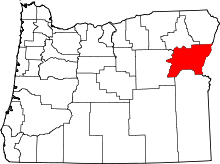 | |
| Unincorporated communities | ||
| Ghost towns | ||
This article is issued from Wikipedia - version of the 11/23/2016. The text is available under the Creative Commons Attribution/Share Alike but additional terms may apply for the media files.