Carrauntoohil
| Carrauntoohil | |
|---|---|
| Corrán Tuathail | |
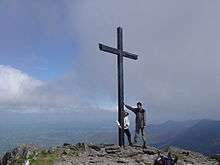
 Carrauntoohil (middle) looking south along the Hag's Glen | |
| Highest point | |
| Elevation | 1,038 m (3,406 ft) [1] |
| Prominence | 1,038 m (3,406 ft) |
| Listing |
Country high point Marilyn, Furth, Hewitt |
| Coordinates | 51°59′58″N 9°44′34″W / 51.999447°N 9.742744°WCoordinates: 51°59′58″N 9°44′34″W / 51.999447°N 9.742744°W |
| Geography | |
 Location in Ireland | |
| Location | County Kerry, Republic of Ireland |
| Parent range | Macgillycuddy's Reeks |
| OSI/OSNI grid | V803844 |
| Topo map | OSI Discovery 78 |
Carrauntoohil (/ˌkærənˈtuːl/, Irish: Corrán Tuathail)[2] is the highest peak on the island of Ireland. Located in County Kerry, Ireland it is 1,038 metres (3,406 ft)[1] high and is the central peak of the Macgillycuddy's Reeks range. The ridge northward leads to Ireland's second-highest peak, Beenkeragh (1,010 m), while the ridge westward leads to the third-highest peak, Caher (1,001 m). Carrauntoohil overlooks three bowl-shaped valleys, each with its own lakes. To the east is Hag's Glen or Coomcallee (Com Caillí, "hollow of the Cailleach"), to the west is Coomloughra (Com Luachra, "hollow of the rushes") and to the south is Curragh More (Currach Mór, "great marsh").
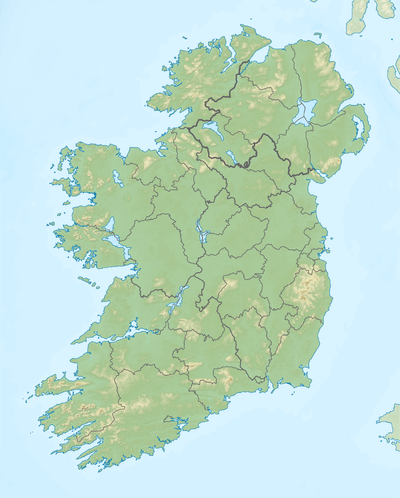
A steel cross, 5 metres (16 ft) tall, was erected on the summit in 1976 but was cut down by vandals in November 2014.[3] The cross was re-erected on Saturday, Nov. 29, 2014.[4]
Carrauntoohil is classed as a Furth by the Scottish Mountaineering Club, i.e. a mountain greater than three thousand feet high that is outside (or furth of) Scotland,[5] which is why it is sometimes referred to as one of the Irish Munros.
Name
The mountain's name has a number of spellings and theories of origin.[6] 'Carrauntoohil' is the most common spelling of the name, and is the one used by Ordnance Survey Ireland. Other spellings include 'Carrantoohil', 'Carrantouhil', 'Carrauntouhil' and 'Carrantuohill'. These are anglicizations of an Irish placename, but its origins and meaning are not clear. "Unlike some lesser peaks, such as Mangerton or Croagh Patrick, it is not mentioned in any surviving early Irish texts".[6] The official Irish name is Corrán Tuathail. This has been interpreted as "inverted sickle" or "Tuathal's sickle", Tuathal being a male firstname.[6] However, one of the earliest mentions of the mountain, by Isaac Weld in 1812, refers to it as 'Gheraun-Tuel'. This suggests that the first element was géarán ("fang")—which is found in the names of other Kerry mountains[6]—and that an earlier name may have been Géarán Tuathail ("Tuathal's fang").[7]
Climbing routes
The mountain is most often climbed from the north-east, along the Hag's Glen and up the steep Devil's Ladder to the col between Carrauntoohil and Cnoc na Toinne, and then north-west to the summit. The route has become more dangerous in recent years due to loose stones and crowding.[8] No special equipment is needed to climb the mountain, but caution is advised. Alternatively, one can walk the two other 1,000 m peaks in a "horseshoe" trip, starting from the west. The traverse from highest point to the second highest involves a light scramble.
See also
- List of mountains in Ireland
- List of Irish counties by highest point
- List of Furths
- List of highest points of European countries
- List of countries by highest point
References
- 1 2 "Mountains, Rivers & Lakes". Ordnance Survey Ireland. 2012. Retrieved 4 August 2012.
- ↑ "Carrauntoohil". Placenames Database of Ireland. Retrieved 2010-01-28.
- ↑ "Vandals cut down iconic Cross on Ireland's highest mountain". BreakingNews.ie. 2014-11-22. Retrieved 22 November 2014.
- ↑ "Carrauntoohil cross restored in dawn mission". IrishExaminer.com. 1 December 2014. Retrieved 9 January 2015.
- ↑ Mountains - Key Facts. The Munros, Corbetts, Grahams, Donalds & Furths at www.smc.org.uk. Accessed on 2 Feb 2013.
- 1 2 3 4 "Carrauntoohil". Mountain Views. Retrieved 23 November 2014.
- ↑ Hendroff, Adrian. From High Places: A Journey Through Ireland's Great Mountains. History Press Ireland, 2012. p.220
- ↑ "Devil's Ladder Route". Kerry mountain rescue. Retrieved 2007-01-10.
External links
 Media related to Carrauntoohil at Wikimedia Commons
- Computer generated summit panoramas North South index
Highest mountains of Ireland (by province) | ||
|---|---|---|
| Munster |
| |
| Leinster |
| |
| Ulster |
| |
| Connacht |
| |