Carnduff
| Carnduff | |
|---|---|
| Town | |
|
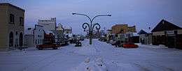
Downtown Carnduff | |
| Motto: "A community on the move" | |
 Carnduff  Carnduff Location of Carnduff | |
| Coordinates: 49°10′01″N 101°46′59″W / 49.167°N 101.783°W | |
| Country | Canada |
| Province | Saskatchewan |
| Region | Saskatchewan |
| Rural Municipality | Mount Pleasant No. 2 |
| Post Office Established | 1884-09-01 |
| Government | |
| • Mayor | Ross Apperley |
| • Administrator | Annette Brown |
| • Governing body | Carnduff Town Council |
| Area | |
| • Total | 2.26 km2 (0.87 sq mi) |
| Population (2011) | |
| • Total | 1,126 |
| • Density | 192.0/km2 (497.3/sq mi) |
| Time zone | CST (winter) / MST (summer) |
| Postal code | S0C 0S0 |
| Area code(s) | 306 |
| [1][2][3] | |
Carnduff is a small agricultural town in Southeastern Saskatchewan, Canada.
History
Carnduff is named after its first postmaster, John Carnduff. It was marked on early CPR maps, though that location did not exactly correspond to the present town site later surveyed in 1891.[4][5]
Though Saskatchewan is in the CST Zone, since 1967 it has not observed daylight saving time and the local clocks do not get changed in summer. A practical effect on border towns like Carnduff is that they only align with neighbouring communities in Manitoba and North Dakota for half the year, which may lead to misunderstandings regarding the timing of scheduled inter-community events.
In 2001, the town was noted as having trees affected by Dutch Elm Disease.[6]
Geography
The town lies at the intersection of Highway 318 and Highway 18. The Canadian Pacific Railway runs parallel to Highway 18 and their combined thoroughfare splits the town into a north half and a south half. The majority of housing and businesses are in the southern half of the town, while the northern half has a majority of the recreation facilities and larger industrial buildings. The Antler River flows around the north side and east of the town, adding a small valley to the otherwise flat local flat prairie.

Severe flooding in the Souris River basin region during the spring and summer of 2011 caused damage to bridges over the Antler River north and east of the town. Significant repair work was required on the Highway 18 bridge near the Viterra terminal.
The nearest locations with a population larger than 10,000 are Estevan 90 km to the west, and Minot, North Dakota 140 km to the southeast. The provincial capital, Regina, is approximately three hours northwest by highway.
Demographics
| Canada census – Carnduff community profile | |||
|---|---|---|---|
| 2011 | 2006 | ||
| Population: | 1,126 (+11.3% from 2006) | 1,012 (-0.5%% from 2001) | |
| Land area: | 2.26 km2 (0.87 sq mi) | 2.05 km2 (0.79 sq mi) | |
| Population density: | 497.3/km2 (1,288/sq mi) | 494.1/km2 (1,280/sq mi) | |
| Median age: | 37.0 (M: 35.5, F: 39.3) | 40.0 (M: 36.7, F: 43.0) | |
| Total private dwellings: | 488 | 454 | |
| Median household income: | $46,757 | ||
| References: 2011[7] 2006[8] | |||
Economy
As a larger town than those adjacent to it, Carnduff is a center of schooling and business activity in the extreme southeastern corner of Saskatchewan. The Gazette Post News, a weekly newspaper, is based in Carnduff and reports on items from the neighboring communities.[9]
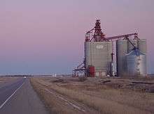
The Saskatchewan Wheat Pool (SWP) built a concrete inland terminal on the rail line a few kilometers east of the town during the late 1990s. In 2010, SWP's successor corporation Viterra started an upgrade project that included an expansion of the rail-yard from 56 to 112 cars and a 7,000 metric ton increase in storage capacity that would result in 33,000 metric tons of capacity.[10]
Because Carnduff is located within the Bakken Formation geological zone, it is surrounded by active oil and gas drilling sites. A large number of businesses in the town are involved in the petroleum industry by providing transportation, construction, or specialized oilfield services.
Sport and Recreation
Sporting sites available in Carnduff include tennis courts, an artificial-ice skating rink, a curling rink, a swimming pool, a five-pin bowling alley, and a rodeo ring. A nine-hole golf course, situated north of the town, opened its grass greens in 1982.[11] The baseball facilities were moved to the west side of town and significantly upgraded in the mid-1990s to a level where the town has hosted provincial- and national-level tournaments in fastpitch softball.
Education
The Carnduff Education Complex is part of School Division SD 209 "Southeast Cornerstone". It opened in 2004 and consolidated two facilities in Carnduff as well as services from other surrounding towns. Students attend classes from kindergarten to Grade 12. The former Carnduff Elementary School and Carnduff High School were re-purposed, with the latter being renamed the Dean Fraser Community Center.[12][13] Some schools in the area, specifically in Gainsborough and Storthoaks were closed, while the Carievale Elementary School [14] was expanded to accommodate more younger students.
Notable People
- Charles Herbert Brereton - Politician
- Maurice Foster - Politician
- Ernest Manning - Politician
- Cecil Sturgeon - Former NFL Player
- Lyle Sturgeon - Former NFL Player
- Harry Wahl - Politician
References
- ↑ National Archives, Archivia Net. "Post Offices and Postmasters". Archived from the original on 2006-10-06. Retrieved 2014-04-26.
- ↑ Government of Saskatchewan, MRD Home. "Municipal Directory System". Archived from the original on 2016-01-15. Retrieved 2014-04-26.
- ↑ Commissioner of Canada Elections, Chief Electoral Officer of Canada (2005). "Elections Canada On-line". Archived from the original on 2007-04-21. Retrieved 2014-04-26.
- ↑ http://www.ourroots.ca/page.aspx?id=3607047&qryID=db730e17-bb8f-4f7c-aa98-f4f0ba7f8b01
- ↑ http://www.ourroots.ca/page.aspx?id=164577&qryID=09312b6e-4b10-4e37-ac79-8edd3c49ec20
- ↑ http://www.cbc.ca/news/canada/story/2001/08/03/dutchelmsk010802.html
- ↑ "2011 Community Profiles". Canada 2011 Census. Statistics Canada. July 5, 2013. Retrieved 2014-04-26.
- ↑ "2006 Community Profiles". Canada 2006 Census. Statistics Canada. March 30, 2011. Retrieved 2009-02-24.
- ↑ http://www.swna.com/?page=newspapers&mid=7
- ↑ Carnduff-Carnduff Gazette Post, June 7, 2010 Archived June 30, 2010, at the Wayback Machine.
- ↑ http://www.golflink.com/golf-courses/course.aspx?course=1980456
- ↑ http://www.carnduff.ca/facilities.html
- ↑ "Archived copy". Archived from the original on 2014-04-28. Retrieved 2012-10-02.
- ↑ "Archived copy". Archived from the original on 2013-09-08. Retrieved 2012-10-02.
External links
 |
Alida | Storthoaks | | |
| Glen Ewen | |
Carievale | ||
| ||||
| | ||||
| North Dakota, USA |
Coordinates: 49°10′01″N 101°46′59″W / 49.167°N 101.783°W