Carleton Island
 Carleton Island Carleton Island (New York) | |
| Geography | |
|---|---|
| Location | St. Lawrence River at Cape Vincent, Jefferson County, New York |
| Coordinates | 44°10′43″N 76°17′17″W / 44.17861°N 76.28806°WCoordinates: 44°10′43″N 76°17′17″W / 44.17861°N 76.28806°W |
| Area | 2.8 sq mi (7.3 km2)[1] |
| Highest elevation | 331 ft (100.9 m)[2] |
| Administration | |
|
New York | |
| County | Jefferson County |
| Demographics | |
| Population | 34 homes with 54 residents (2008) |
Carleton Island is located in the St Lawrence River in upstate New York. It is part of the Town of Cape Vincent, in Jefferson County.
History
Originally held by the Iroquois, the first European to take notice of the island was Pierre François Xavier de Charlevoix, in 1720. He called it Isle aux Chevreuils, the Island of Roe Bucks, and wrote in 1721 that its bays could be useful. [3] It was also referred to as Buck Island or Deere Island.[4][5] During the American Revolutionary War the British used the island as a military supply transshipment location and the island was fortified. There was also a dockyard.[6]
The island was renamed Carleton Island after Major General Sir Guy Carleton, Governor of the Province of Quebec. It was one of several islands in the area that were named by John Graves Simcoe after General James Wolfe's adjutants in the Battle of the Plains of Abraham. The largest is Wolfe island, while the others are Howe Island, Amherst Island, and Gage Island (now Simcoe Island).
Fort Haldimand
|
Fort Haldimand Site | |
|
Remains of Fort Haldimand, 1906 | |
|
| |
| Nearest city | Cape Vincent, New York |
|---|---|
| Area | 25 acres (10 ha) |
| Built | 1778 |
| Built by | Twiss, William |
| NRHP Reference # | 78001854[7] |
| Added to NRHP | December 15, 1978 |
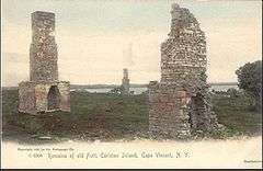
Carleton Island was the location of Fort Haldimand, initially called Fort Carleton,[8] which was controlled by the British during the American Revolutionary War. It was strategically important as well as being a center of shipbuilding. The fort was built in 1778 and named after British General Frederick Haldimand. It was built on the southwest end of the island, shaped as a partial octagon, and consisted of bastions, ditches, barracks and magazines.
Several British regiments garrisoned the fort, including the Royal Artillery, the Royal Marines, Butler's Rangers, the King's Royal Regiment of New York, and the Royal Highland Emigrants. The island served as a base for raids against American towns by Indians loyal to the British.[6]
The ruins of the fort can still be seen at the southwest end of the island along northeast side of North Bay.
There are three known burial grounds near the fort:[9]
- Military burial grounds - 25 burial located on the north side and beyond the walls of Fort Carleton
- Indian burial grounds - located on the northwest shore near the Fort Carleton
- Civilian burial grounds - located east of the fort
The Fort Haldimand Site was added to the National Register of Historic Places in 1978.[7]
Dockyard and shipbuilding
Projecting from the location of the fort is Government Point, notched by two small bays:
- 'North Bay or Schank's Harbor was home to Carleton Island Dockyard, a shipyard that operated from 1774 to 1792. Likely named for John Schank, a British shipbuilder. A military dock was located on the southwest end of the bay at Aubrey Head
- South Bay or Government Harbor was used by Royal Navy/Provincial Marine vessels servicing the fort.
Many ships for the war were built at the island along the southeast shores of North Bay, including the recently discovered HMS Ontario.[10] Other known vessels built include:
- HMS Mississauga 1792 - warship
- HMS Limnade 1780–81 - warship[11]
Some vessels sunk in North Bay can be seen near the old military dock at Aubrey's Head.
Loyalist refuge
Since Carleton Island was in the hands of the British, Loyalists who were escaping rebel persecution fled to the island, built homes and carried on businesses. When the island was ceded to the United States after the Revolutionary War, many of these civilian residents moved to nearby Cataraqui (now Kingston, Ontario).[12]
Merchants and their warehouses were located northwest of the fort in an area known as Merchant's Cove and Merchant's Point.[13]
Demise
At the close of the war of independence, under the terms of Jay's Treaty, the British ceded Carleton Island, along with other forts, to the Americans. The forts were apparently not, however, abandoned by the British at that time.
Construction of the fort was halted in 1783 and the post was abandoned in 1812. The ruins of the fort now consists of the outline of ramparts and barrack's chimney as the fort's buildings (barracks, magazine house) were made of wood and were lost over time.[14] The fort is now covered by tree growth along the northeast shore of North Bay.
During the War of 1812, Carleton Island was captured without bloodshed by three freelancing Americans, though it was already nominally American territory due to Jay's Treaty. In 1817, the State Legislature of New York annexed the island to Jefferson County, and granted 500 acres (2.0 km2) of its land to the local New York postmaster, Charles Smyth. The island had been a haven for smugglers, and later that year a Canadian tax collector seized some tobacco from the island. This dispute escalated, and Governor DeWitt Clinton of New York threatened hostilities. Soon Secretary of State John Quincy Adams was called upon to sort out the matter.[15] After contentious negotiations, the island was retained by the United States and was turned over to peaceful pursuits of farming (now abandoned), sport-fishing, and summer tourism.[16] No one lives on the island year-round.
Administration
- New France 1720s–1763
- Province of Quebec (British America and then British North America) 1778–1791
- Upper Canada (British North America) 1792–1794
- New York State 1817–present (nominally since 1794 under the Jay's Treaty)
Wyckoff Villa
In 1890s Wyckoff Villa was built by William O. Wyckoff, a sales agent for E. Remington and Sons, who later formed the Standard Typewriter Manufacturing Company, Incorporated in 1886. Designed by William Henry Miller, the Richardsonian Romanesque-Tudor Revival hybrid mansion was occupied briefly as Wyckoff died a day after moving into the mansion in 1895.[1] The property was briefly held by General Electric, which had intended to transform the property into a corporate retreat, however these plans were abandoned during World War II. The mansion is crumbling with a tower that has since collapsed.
Carleton Island today
There are 34 homes with most located along the shores of the island. The homes are connected by Carleton Island Road 1 and Carleton Island Road 2, a series of dirt trails used by residents on ATVs.[1]
A pair of silos on one property on the southeast side of have been converted as private residences that double as observation towers.[1] There are several abandoned boat houses located along South Bay.[1]
The island was once served by a ferry running from the island to the village of Cape Vincent, but it is no longer in service. Today, the only way to get to the island from the mainland and surrounding islands is by private boat. Area residents use their own private boats as most homes have their own piers to dock their vessels.[1]
References
- 1 2 3 4 5 6 Lunman, Kim (2008-09-15). "Ghost of a gilded age: Carleton Island's Wyckoff Villa". Thousand Islands Life Magazine. Retrieved 2010-06-23.
- ↑ "Carleton Island". Geographic Names Information System. United States Geological Survey.
- ↑ History of Cape Vincent
- ↑ Fort Haldimand Retrieved November 17, 2016
- ↑ Fort Haldimand History Retrieved November 19, 2016
- 1 2 Mika, Nick and Helma et al. Kingston, Historic City. Belleville: Mika Publishing Co., 1987. p. 18
- 1 2 National Park Service (2010-07-09). "National Register Information System". National Register of Historic Places. National Park Service.
- ↑ New York State Military Museum and Veterans Research Center Retrieved November 18, 2016
- ↑ http://www.forthaldimand.com/p/burial-grounds.html
- ↑ Ernest Cruikshank, A Souvenir of the St. Lawrence River
- ↑ http://www.thousandislandsretreat.com/island.htm
- ↑ Mika, Nick and Helma et al. Kingston, Historic City. Belleville: Mika Publishing Co., 1987. pp.18-21
- ↑ http://www.thousandislandslife.com/BackIssues/Archive/tabid/393/articleType/ArticleView/articleId/752/The-Diggerhellip-on-Carleton-Island.aspx
- ↑ http://www.seawaytrail.com/images/storytellers/large/Fort-Haldimand-%28Carleton%29.jpg
- ↑ Memoirs of John Quincy Adams: Comprising Portions of His Diary from 1795 to 1848, pp 394-399
- ↑ John A. Haddock and Eli Thayer. 1894. The Growth of a Century: As Illustrated in the History of Jefferson County, 112-113