Carleton County, New Brunswick
| Carleton | |
|---|---|
| County | |
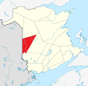 Location within New Brunswick. | |
| Country |
|
| Province |
|
| Established | 1831 |
| Electoral Districts Federal |
Tobique—Mactaquac |
| Provincial | Carleton & Victoria-Tobique |
| Area[1] | |
| • Land | 3,313.15 km2 (1,279.21 sq mi) |
| Population (2011)[1] | |
| • Total | 27,019 |
| • Density | 8.2/km2 (21/sq mi) |
| • Pop 2006-2011 |
|
| • Dwellings | 11,742 |
| Time zone | AST (UTC-4) |
| • Summer (DST) | ADT (UTC-3) |
| Area code(s) | 506 |
Carleton County (2011 population 27,019) is located in west-central New Brunswick, Canada.
The western border is Aroostook County, Maine, the northern border is Victoria County, and the southeastern border is York County from which it was formed in 1831. The Saint John River bisects the western section of the county. The Southwest Miramichi River flows through the eastern section of the county. Potato farming is a major industry. The scenic town of Hartland is home to the longest covered bridge in the world.
Transportation
Major Highways
Census subdivisions
Communities
There are five incorporated municipalities within Carleton County (listed by 2011 population):[1]
| Official Name | Designation | Area km2 | Population | Parish |
|---|---|---|---|---|
| Woodstock | Town | 13.41 | 5,254 | Woodstock |
| Florenceville-Bristol | Town | 15.61 | 1,639 | Simonds |
| Hartland | Town | 9.63 | 947 | Brighton |
| Centreville | Village | 2.69 | 542 | Wicklow |
| Bath | Village | 2.03 | 532 | Kent |
First Nations
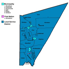
There is one First Nations reserve in Carleton County (listed by 2011 population):[1]
| Official Name | Designation | Area km2 | Population | Parish |
|---|---|---|---|---|
| Woodstock 23 | Reserve | 1.77 | 345 | Woodstock |
Parishes
The county is subdivided into eleven parishes (listed by 2011 population):[1]
| Official Name | Area km2 | Population | municipalities | Unincorporated communities |
|---|---|---|---|---|
| Wakefield | 196.57 | 2,814 | Belleville / Briggs Corner / Hartford / Iron Ore Hill / Jackson Falls / Jacksontown / Jacksonville / Lindsay / Lower Wakefield / Lower Waterville / McKenna / Oakville / Rosedale / Somerville / South Greenfield / South Wakefield / Upper Waterville / Victoria Corner / Wakefield / Waterville | |
| Kent | 839.81 | 2,242 | Bath (village) | Beaufort / Beechwood / Carlow / Chapmanville / Clearview / Giberson Settlement / Gordonsville / Haut-Kent / Holmesville / Johnville / Kenneth / Kent / Kilfoil / Killoween / Lockharts Mill / Maplehurst / Monquart / Moose Mountain / Murphy Corner / Piercemont / River de Chute Siding / South Johnville / Summit / Tarrtown / Upper Kent / Haut-Kent / Welch |
| Woodstock | 196.96 | 2,165 | Woodstock (town) Woodstock 23 (reserve) |
Beardsley Road / Bedell / Benton / Bulls Creek / Dibblee / Hillman / Indian Village / Mapledale / Porten Settlement / Riceville / River Road / Speerville / Springfield / Teeds Mills / Townsview Estates / Upper Southampton / Upper Woodstock / Valley |
| Northampton | 243.45 | 1,825 | Carr / East Newbridge / Grafton / Grafton Hill / Harten Corner / Kilmarnock / Lower Northampton / Newbridge / Newburg / Northampton / Pembroke / South Newbridge / Upper Northampton | |
| Brighton | 508.34 | 1,764 | Hartland (town) | Armond / Ashland / Briggs Corner / Brighton / Carlisle / Cloverdale / Coldstream / East Brighton / East Cloverdale / Esdraelon / Howard Brook / Jericho / Lower Brighton / Lower Windsor / Mainstream / Mountain View / Pole Hill / Shewan / Simonds / South Knowlesville / Windsor |
| Wicklow | 195.69 | 1,738 | Centreville (village) | Clearview / Gregg Settlement / Hartley Settlement / Knoxford / Lamoreaux Corner / Listerville / Lower Greenfield / McGrath Corner / McMonagle Corner / Middle Greenfield / Royalton / Summerfield / Thomas Corner / Tracey Mills / Tweedie / Upper Knoxford / Upper Royalton / Upper Wicklow / Wakem Corner / Wicklow |
| Richmond | 259.14 | 1,358 | Blackies Landing / Blowdown / Campbell Settlement / Debec / Elmwood / Elmwood Station / Green Road / Houlton Road / Irish Settlement / Kirkland / Limestone / McKenzie Corner / Monument / Oak Mountain / Plymouth / Richmond / Richmond Corner / Union Corner / Watson Settlement / Wickham | |
| Peel | 113.12 | 1,223 | Buckwheat Brook / East Coldstream / Lansdowne / Mount Pleasant / Oakland / Peel / Riverbank / South Gordonsville / Stickney | |
| Wilmot | 191.45 | 1,085 | Avondale / Beckim Settlement / Bloomfield / Bradley Corner / Brookville / Carvell / Charleston / Deerville / Digby Corner / Good Corner / Lakeville / Long Settlement / Lower Bloomfield / McKeaghan / Weston / Wilmot | |
| Aberdeen | 447.91 | 981 | Aberdeen / Argyle / Biggar Ridge / Centre Glassville / Divide / East Glassville / East Knowlesville / Foreston / Glassville / Hayden Ridge / Hemphill Corner / Highlands / Juniper / Juniper Station / Ketchum Ridge / Knowlesville / MacIntosh Mill / North Ridge / South Ridge / West Glassville | |
| Simonds | 75.57 | 565 | Florenceville-Bristol (town) | Carleton / Connell / Flanagan Hill / Hunters Corner / Simonds / St. Thomas / Strong Corner / Upper Brighton |
Demographics
|
Population trend[2]
|
Mother tongue language (2011)[1]
|
Access Routes
Highways and numbered routes that run through the county, including external routes that start or finish at the county limits:[3]
|
|
Protected areas and attractions
Notable people
See also
References
- Ketchum, T.C.L. (1981) [1922]. A Short History of Carleton County New Brunswick (2nd ed.). Non-Entity Press. 86pp. ISBN 0-9690215-5-0.
External links
| Wikimedia Commons has media related to Carleton County, New Brunswick. |
- Carleton County Colloquialisms
- McCain Foods Ltd
- Town of Woodstock
- Town of Hartland
- Falls Brook Centre
 |
Victoria County | | ||
| |
|
York County | ||
| ||||
| | ||||
| York County |
| Subdivisions | |
|---|---|
| Cities | |
| Counties | |
| |
Coordinates: 46°21′N 67°19′W / 46.350°N 67.317°W