Capitol Area Historic District
|
Capitol Area Historic District | |
|
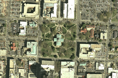
Capitol satellite view, August 2006 | |
  | |
| Location | State Capitol building and environs, Raleigh, North Carolina |
|---|---|
| Coordinates | 35°46′48″N 78°38′15″W / 35.78000°N 78.63750°WCoordinates: 35°46′48″N 78°38′15″W / 35.78000°N 78.63750°W |
| Area | 40 acres (16 ha) |
| Architectural style | Classical Revival, Late Gothic Revival |
| NRHP Reference # | 78001978[1] |
| Added to NRHP | April 15, 1978 |
The Capitol Area Historic District is a national historic district located at Raleigh, North Carolina. The district encompasses 25 contributing buildings and was developed after 1792. The district includes notable examples of Classical Revival and Late Gothic Revival style architecture. Located in the district are the following separately listed buildings:
- Agriculture Building, at 2 W. Edenton St.
- Christ Episcopal Church, at 120 E. Edenton St.
- Richard B. Haywood House, at 127 E. Edenton St.,
- Haywood Hall, at 211 New Bern Pl.,
- North Carolina State Capitol,
- Raleigh Water Tower, 115 W. Morgan St.
- State Bank of North Carolina, at 123 New Bern Pl.,
- White-Holman House, New Bern Ave.
Other notable buildings include the First Baptist Church (1859), All Saints Chapel (1873), Church of the Good Shepherd (1914), Cathedral of the Sacred Heart (1922), Supreme Court and State Library Building (1888), Ruffin Building (1913), Revenue Building (1927), Education Building (1938, 1947), Justice Building (1939-1940), Highway Building (1950), Dr. Andrew Watson Goodwin House, and Montgomery House (1906).[2]
It is also one of six Historic Overlay Districts in Raleigh. It was listed in 1978 on the National Register of Historic Places.[1]
External links
- National Register Historic Districts in Raleigh, North Carolina, RHDC
- Capital Square Historic Overlay District, RHDC
References
- 1 2 National Park Service (2010-07-09). "National Register Information System". National Register of Historic Places. National Park Service.
- ↑ H. McKelden Smith and Joe Mobley (n.d.). "Capitol Area Historic District" (pdf). National Register of Historic Places - Nomination and Inventory. North Carolina State Historic Preservation Office. Retrieved 2015-06-01.

