Cape York (Mars)

Cape York is a location on Mars, on the western rim of Endeavour crater.[1] Opportunity rover spend about two years exploring this portion of the rim in the early 2010s before moving south.[1] The CRISM instrumet on the orbiting Mars Reconnaissance Orbiter identified clay smectites in an area of Cape York, and the rover was sent to explore this location.[1] MER-B Opportunity spend its fith Martian Winter at Greeley Haven at Cape York, and also took a panorma at that location.[2] MER-B spent 19 weeks stationed at Greeley Haven surviving the winter and went on the move again in May 2012, to further explore Cape York.[3]
MER-B arrived at Cape York in 2011 at Odyssey crater, which is on the southern end of the feature.[4] Opportunity arrived at Endeavour crater on sol 2709 (August 9, 2011), at a landmark called Spirit Point named after its rover twin, after traversing 21 km (13 mi) from Victoria crater, over a three-year period.[5] Spirit point was the name selected for where MER-B arrived at Endeavour's Cape York, a journey which it set out on in 2008 and it arrived there in the summer of 2011.[6]
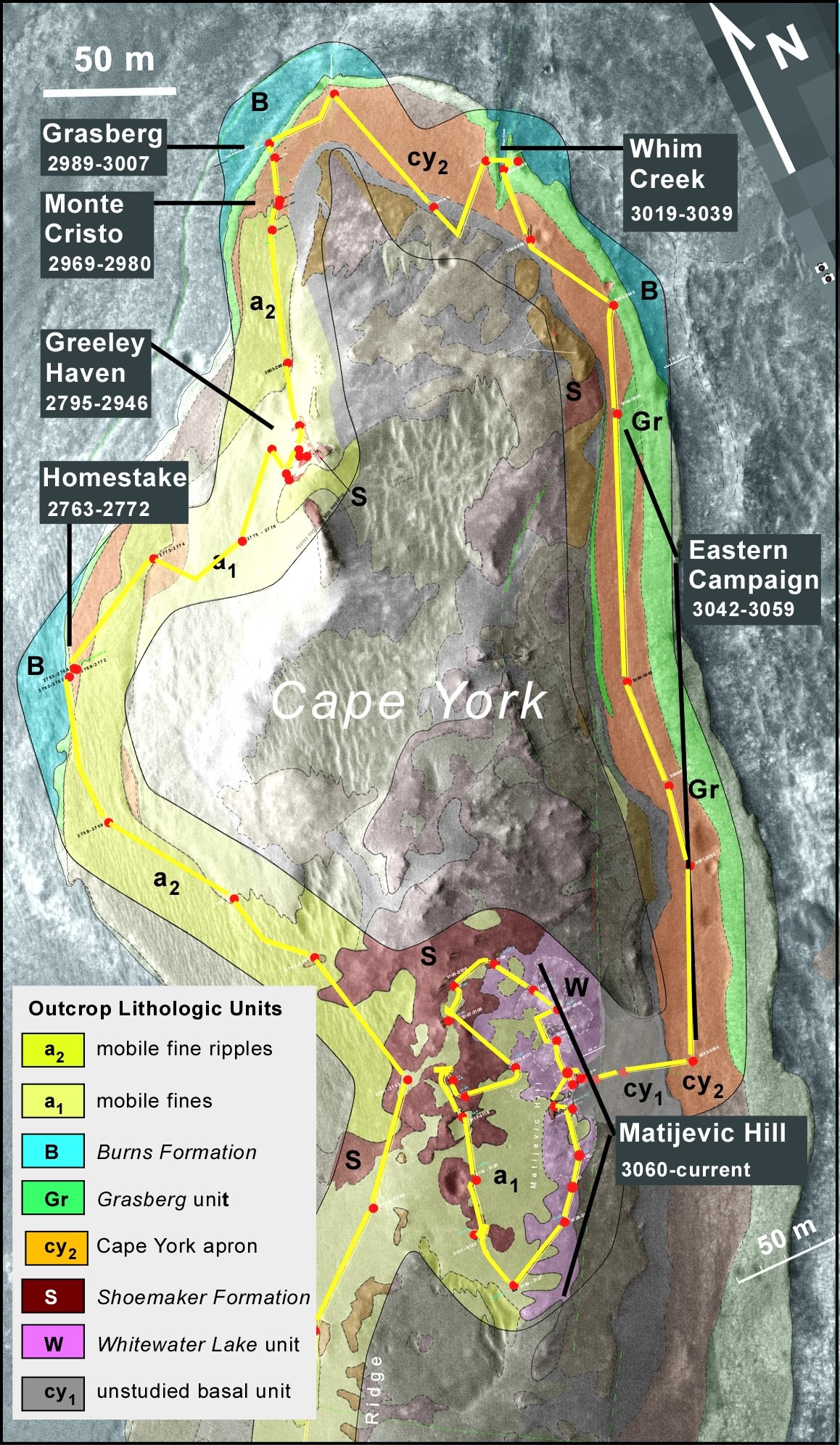
Locations and science targets at Cape York include:[7] (Alphabetically ordered:)
- Chester Lake[8]
- Esperance
- Grasberg
- Greeley Haven
- Homestake rock
- Matejavic Hill
- Monte Cristo
- Odyssey crater[4]
- Spirit Point[6]
- Tisdale 2[8]
- Whitewater Lake outcrops
- Whim Creek
South of Cape York is an area called Botany Bay.[8] Features south of Cape York include Sutherland Point, Nobby's Head, and even father south Solander Point
Location


MER-B traverse around Cape York


Locations and/or science targets at Cape York


Matijevic Hill


Views


See also
References
- 1 2 3 mars.nasa.gov. "'Cape York' Explored".
- ↑ "NASA - 'Greeley Panorama' from Opportunity's Fifth Martian Winter".
- ↑ "Opportunity is a ROVER again!".
- 1 2 "Odyssey Crater on Cape York, sol 2681 (anaglyph)".
- ↑ "NASA Mars Rover Arrives at New Site on Martian Surface". Jet Propulsion Laboratory. August 10, 2011.
- 1 2 "NASA - Opportunity Heads Toward 'Spirit Point'". Nasa.gov. 2011-06-08. Retrieved 2016-10-13.
- ↑ "Mars Exploration Rovers Special Update: Opportunity's Findings at Endeavour, So Far".
- 1 2 3 "Mars Exploration Rovers Update: Opportunity Digs Cape York, Roves to New Milestone".
External links
Features on Mars visited by Opportunity rover | ||
|---|---|---|
| Craters | | |
| Endeavour | ||
| Rocks | ||