Cap-d'Ail
| Cap-d'Ail | ||
|---|---|---|
|
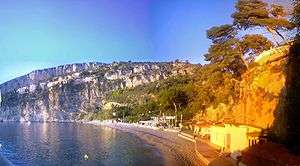
A general view of Cap-d'Ail | ||
| ||
 Cap-d'Ail | ||
|
Location within Provence-A.-C.d'A. region  Cap-d'Ail | ||
| Coordinates: 43°43′19″N 7°24′23″E / 43.7219°N 7.4064°ECoordinates: 43°43′19″N 7°24′23″E / 43.7219°N 7.4064°E | ||
| Country | France | |
| Region | Provence-Alpes-Côte d'Azur | |
| Department | Alpes-Maritimes | |
| Arrondissement | Nice | |
| Canton | Villefranche-sur-Mer | |
| Intercommunality | Nice-Côte d'Azur | |
| Government | ||
| • Mayor (2008–2014) | Xavier Beck | |
| Area1 | 2.04 km2 (0.79 sq mi) | |
| Population (2008)2 | 4,997 | |
| • Density | 2,400/km2 (6,300/sq mi) | |
| Time zone | CET (UTC+1) | |
| • Summer (DST) | CEST (UTC+2) | |
| INSEE/Postal code | 06032 / 06320 | |
| Elevation | 0–540 m (0–1,772 ft) | |
|
1 French Land Register data, which excludes lakes, ponds, glaciers > 1 km² (0.386 sq mi or 247 acres) and river estuaries. 2 Population without double counting: residents of multiple communes (e.g., students and military personnel) only counted once. | ||


Cap-d'Ail (French pronunciation: [kap daj]), Italian: Capodaglio or Capo d'Aglio, Occitan: Caup d'Alh) is a commune in the Alpes-Maritimes department in southeastern France.
Beach of la Mala
It borders the district of La Colle in the Principality of Monaco.
Modern Cap d'Ail is a modern seaside resort with a lively shopping district on the Basse Corniche and quiet, fashionable residential quarters. Many people who work in Monaco live here. Plage la Mala is prized by many day trippers from Monaco and Nice.
Population
| Historical population | ||
|---|---|---|
| Year | Pop. | ±% |
| 1968 | 4,200 | — |
| 1975 | 4,282 | +2.0% |
| 1982 | 4,402 | +2.8% |
| 1990 | 4,859 | +10.4% |
| 1999 | 4,532 | −6.7% |
| 2008 | 4,997 | +10.3% |
See also
References
| Wikimedia Commons has media related to Cap-d'Ail. |
This article is issued from Wikipedia - version of the 12/3/2016. The text is available under the Creative Commons Attribution/Share Alike but additional terms may apply for the media files.