Canyon de Chelly National Monument
| Canyon de Chelly National Monument | |
|---|---|
|
IUCN category V (protected landscape/seascape) | |
|
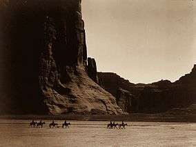
Canyon de Chelly, 1904, by Edward S. Curtis | |
 | |
| Location | Apache County, Arizona, USA |
| Nearest city | Chinle |
| Coordinates | 36°09′19″N 109°30′32″W / 36.1552818°N 109.5089952°W[1]Coordinates: 36°09′19″N 109°30′32″W / 36.1552818°N 109.5089952°W[1] |
| Area | 83,840 acres (33,929 ha)[2] |
| Created | April 1, 1931 |
| Visitors | 828,478 (in 2013)[3] |
| Governing body | Bureau of Indian Affairs |
| Website | Canyon de Chelly National Monument |
| NRHP Reference # | 70000066 |
| Added to NRHP | August 25, 1970[4] |
Canyon de Chelly National Monument (/dəˈʃeɪ/ də·shā′) was established on April 1, 1931 as a unit of the National Park Service. It is located in northeastern Arizona within the boundaries of the Navajo Nation. Reflecting one of the longest continuously inhabited landscapes of North America, it preserves ruins of the early indigenous tribes that lived in the area, including the Ancient Pueblo Peoples (also called Anasazi) and Navajo. The monument covers 83,840 acres (131.0 sq mi; 339.3 km2) and encompasses the floors and rims of the three major canyons: de Chelly, del Muerto, and Monument. These canyons were cut by streams with headwaters in the Chuska mountains just to the east of the monument. None of the land is federally owned.[5] In 2009 Canyon de Chelly National Monument was recognized as one of the most-visited national monuments in the United States.[6]
Etymology
The name chelly (or Chelley) is a Spanish borrowing of the Navajo word Tséyiʼ, which means "canyon" (literally "inside the rock" < tsé "rock" + -yiʼ "inside of, within"). The Navajo pronunciation is [tséɣiʔ]. The Spanish pronunciation of de Chelly [deˈtʃeʎi] was adapted into English, apparently through modelling after a French-like spelling pronunciation, and now English pronunciation: /dəˈʃeɪ/ də·shā′.
History
Canyon de Chelly long served as a home for Navajo people before it was invaded by forces led by future New Mexico governor Lt. Antonio Narbona in 1805. In 1863 Col. Kit Carson sent troops to either end of the canyon to defeat the Navajo population within. The resulting devastation led to the surrender of the Navajos and their removal to Bosque Redondo, New Mexico.[7]
Description
Canyon de Chelly is entirely owned by the Navajo Tribal Trust of the Navajo Nation. It is the only National Park Service unit that is owned and cooperatively managed in this manner.[8][9] Approximately 40 Navajo families live in the park.[10] Access to the canyon floor is restricted, and visitors are allowed to travel in the canyons only when accompanied by a park ranger or an authorized Navajo guide.[11] The only exception to this rule is the White House Ruin Trail.
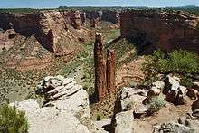
The park's distinctive geologic feature, Spider Rock, is a sandstone spire that rises 750 feet (229 m) from the canyon floor at the junction of Canyon de Chelly and Monument Canyon. Spider Rock can be seen from South Rim Drive. It has served as the scene of a number of television commercials. According to traditional Navajo beliefs the taller of the two spires is the home of Spider Grandmother.[12]
Most park visitors arrive by automobile and view Canyon de Chelly from the rim, following both North Rim Drive and South Rim Drive. Ancient ruins and geologic structures are visible, but in the distance, from turnoffs on each of these routes. Deep within the park is Mummy Cave. It features structures that have been built at various times in history. Private Navajo-owned companies offer tours of the canyon floor by horseback, hiking or 4-wheel drive vehicle. The companies can be contacted directly for prices and arrangements. There is no entrance fee to enter the park, apart from any charges imposed by tour companies.
Accommodations for visitors are located in the vicinity of the canyon, on the road leading to Chinle, which is the nearest town.
The National Monument was listed on the National Register of Historic Places on August 25, 1970.[4]
Gallery
 White House Ruin, 1873
 Antelope House Ruin
 First Ruin
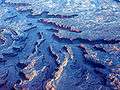 Aerial view
 Park map
See also
References
- 1 2 "Canyon de Chelly National Monument". Geographic Names Information System. United States Geological Survey. Retrieved 2011-06-29.
- ↑ "Listing of acreage as of December 31, 2013". Land Resource Division, National Park Service. Retrieved 2014-03-28.
- ↑ "NPS Annual Recreation Visits Report". National Park Service. Retrieved 2014-03-28.
- 1 2 National Park Service (2009-03-13). "National Register Information System". National Register of Historic Places. National Park Service.
- ↑ "The National Parks: Index 2009–2011". National Park Service. Archived from the original on 2011-06-29. Retrieved 2011-06-29.
- ↑ "America's 20 most-visited National Monuments". Los Angeles Times.
- ↑ Byrd H. Granger (1960). Arizona Place Names. University of Arizona Press. p. 8. Retrieved 20 November 2011.
- ↑ Brugge, David M.; Wilson, Raymond (1976). Administrative History: Canyon de Chelly National Monument, Arizona. National Park Service.
- ↑ "Planning Your Visit (brochure)" (PDF). Canyon de Chelly National Monument. National Park Service. Retrieved 24 January 2013.
- ↑ "History & Culture". Canyon de Chelly National Park. National Park Service. Retrieved 24 January 2013.
- ↑ Egan, Timothy (June 16, 2011). "The Best Unknown Park in America". New York Times.
- ↑ Tobert, Natalie; Pitt, Fiona (1994). Taylor, Colin F., ed. Native American Myths and Legends. Salamander books ltd. p. 35. ISBN 0-86101-753-6.
- Grant, Campbell (1983). Canyon de Chelly: Its People and Rock Art. University of Arizona Press. ISBN 0-8165-0523-3.
External links
| Wikimedia Commons has media related to Canyon de Chelly National Monument. |
| Wikivoyage has a travel guide for Canyon de Chelly National Monument. |
- Official website
- "Canyon de Chelly National Monument". Geology Fieldnotes. National Park Service. Archived from the original on 2011-06-13. Retrieved 2011-06-29.
- Historic American Buildings Survey (HABS) No. AZ-157, "Antelope House Ruin, Canyon del Muerto, Chinle vicinity, Apache County, AZ"
- HABS No. AZ-213, "Bad Trail Ruin, Chinle vicinity, Apache County, AZ"
- HABS No. AZ-211, "Ledge Ruin, Canyon del Muerto, Chinle vicinity, Apache County, AZ"
- HABS No. AZ-72, "Mummy Cave, Navajo Indian Reservation, Chinle vicinity, Apache County, AZ"
- HABS No. AZ-156, "White House Ruin, Navajo Indian Reservation, Chinle vicinity, Apache County, AZ"
- HABS No. AZ-212, "Yucca House Ruin, Canyon del Muerto, Chinle vicinity, Apache County, AZ"
- Canyon de Chelly (poem by Simon Ortiz, 1977) Accessed 2013 January 15
| Topics | |
|---|---|
| Lists by states |
|
| Lists by insular areas | |
| Lists by associated states | |
| Other areas | |
| |