Cantello
For other uses, see Cantello (disambiguation).
| Cantello | |
|---|---|
| Comune | |
| Comune di Cantello | |
 | |
.svg.png) | |
 Cantello Location of Cantello in Italy | |
| Coordinates: 45°49′N 8°53′E / 45.817°N 8.883°ECoordinates: 45°49′N 8°53′E / 45.817°N 8.883°E | |
| Country | Italy |
| Region | Lombardy |
| Province / Metropolitan city | Province of Varese (VA) |
| Frazioni | Gaggiolo, Ligurno |
| Area | |
| • Total | 9.1 km2 (3.5 sq mi) |
| Elevation | 404 m (1,325 ft) |
| Population (Dec. 2004) | |
| • Total | 4,409 |
| • Density | 480/km2 (1,300/sq mi) |
| Time zone | CET (UTC+1) |
| • Summer (DST) | CEST (UTC+2) |
| Postal code | 21050 |
| Dialing code | 0332 |
| Website | Official website |
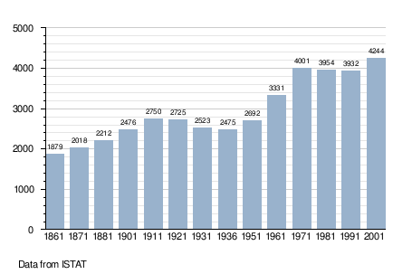
Cantello is a comune (municipality) in the Province of Varese in the Italian region Lombardy, located about 45 kilometres (28 mi) northwest of Milan and about 4 kilometres (2 mi) east of Varese, on the border with Switzerland. As of 31 December 2004, it had a population of 4,409 and an area of 9.1 square kilometres (3.5 sq mi).[1]
The municipality of Cantello contains the frazioni (subdivisions, mainly villages and hamlets) Gaggiolo and Ligurno.
Cantello borders the following municipalities: Arcisate, Cagno, Clivio, Malnate, Rodero, Stabio (Switzerland), Varese, Viggiù.
Demographic evolution
References
External links
This article is issued from Wikipedia - version of the 1/31/2015. The text is available under the Creative Commons Attribution/Share Alike but additional terms may apply for the media files.