Canal du Faux-Rempart
| Canal du Faux-Rempart | |
|---|---|
|
The Canal du Faux-Rempart and Pont de la Fonderie | |
| Specifications | |
| Length | 2 km (1.2 mi) [1] |
| Locks | 1 [1] |
| Status | Open to trip boats only |
| History | |
| Date of first use |
13th century (defense work) 1840 (for navigation) |
| Geography | |
| Beginning coordinates | 48°34′50″N 7°44′18″E / 48.580649°N 7.738251°ECoordinates: 48°34′50″N 7°44′18″E / 48.580649°N 7.738251°E |
| Ending coordinates | 48°35′00″N 7°45′26″E / 48.583389°N 7.757156°E |
| Connects to | River Ill [1] |

The Canal du Faux-Rempart, also known as the Fossé du Faux-Rempart, is a canal in the centre of the city of Strasbourg in eastern France. The canal connects at both ends to the River Ill, thus surrounding the Grande Île that lies at the historic centre of the city.[1][2]
The canal was originally an arm of the River Ill. Initially the bank on the inner, or city, side of the arm was fortified. In the thirteenth century a further wall was built along the middle of the channel. This fortified wall became known as the Faux Rempart or false rampart. Between 1831 and 1832, the mayor Frédéric de Turckheim removed the Faux Rempart in order to "allow a spacious navigation channel and freight transport within the city." In 1840, the canal was opened to navigation.[3][4]
In its 2-kilometre (1.2 mi) length, the canal is crossed by 13 bridges, and passes through a single lock. Navigation is officially restricted to passenger trip boats only, which operate frequent circular cruises round the Grande Île and through the historic Petite France district of the city.[1][2][5]
Gallery
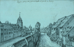 Drawing of the Faux Rempart in 1650
 The upstream end of the canal, with the single lock
 The Pont du Marché
 Trip boat at the Pont du Théâtre
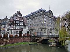 The Pont Saint-Étienne at the downstream end
See also
| Wikimedia Commons has media related to Canal du Faux-Rempart. |
References
- 1 2 3 4 5 McKnight, Hugh (2005). Cruising French Waterways, 4th Edition. Sheridan House. ISBN 978-1-57409-087-1.
- 1 2 McKnight, Hugh (2013). Cruising French Waterways, Kindle Edition. Adlard Coles. p. 115. Retrieved 24 September 2015.
- ↑ Alsace (in French). Strasbourg: Hachette-Guides Bleus. 1990. p. 439.
- ↑ Livet, Georges; Rapp, Francis (1987). Histoire de Strasbourg [History of Strasbourg] (in French). Toulouse: Privat. p. 308. ISBN 2-7089-4726-5.
- ↑ "Strasbourg" (Map). Google Maps. Google. Retrieved 24 September 2015.