Campbells Creek (West Virginia)
| Campbells Creek | |
 Campbells Creek near Coal Fork | |
| Country | United States |
|---|---|
| State | West Virginia |
| County | Kanawha |
| Source | |
| - location | near Putney |
| - elevation | 1,430 ft (436 m) [1] |
| - coordinates | 38°17′47″N 81°21′52″W / 38.2964914°N 81.3645597°W [2] |
| Mouth | Kanawha River |
| - location | near Port Amherst |
| - elevation | 568 ft (173 m) [2] |
| - coordinates | 38°19′00″N 81°33′46″W / 38.3167660°N 81.5628989°WCoordinates: 38°19′00″N 81°33′46″W / 38.3167660°N 81.5628989°W [2] |
| Length | 18.5 mi (30 km) |
| Basin | 39.3 sq mi (102 km2) |
| Hydrologic Unit Code | 050500060404 (USGS) |
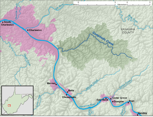 A map of Campbells Creek and its watershed
| |
Campbells Creek is a tributary of the Kanawha River, 18.5 miles (29.8 km) long,[3] in West Virginia in the United States. Via the Kanawha and Ohio rivers, it is part of the watershed of the Mississippi River, draining an area of 39.3 square miles (102 km2)[4] on the unglaciated portion of the Allegheny Plateau, in the Charleston metropolitan area.
Campbells Creek flows for its entire length in Kanawha County. It rises approximately 0.4 miles (0.64 km) east of the unincorporated community of Putney and flows northwestward through Putney and the unincorporated communities of Annfred, Blount, Cinco, and Fivemile; then southwestward through the unincorporated communities of Tad and Coal Fork. It flows into the Kanawha River approximately 0.5 miles (0.80 km) north-northwest of Port Amherst. The creek is paralleled by county roads for most of its course.[5][6]
The Geographic Names Information System lists "Campbell Creek," "Campbell's Creek," and "Nip-pi-pin-mah" as historical variant names for the creek.[2]
See also
References
- ↑ The National Map elevation for GNIS source coordinates. Retrieved 2013-11-22.
- 1 2 3 4 Geographic Names Information System. "Geographic Names Information System entry for Campbells Creek (Feature ID #1536980)". Retrieved 2013-11-22.
- ↑ United States Environmental Protection Agency. "West Virginia, Upper Kanawha Watershed". Archived from the original on 2013-11-15. Retrieved 2013-11-22.
- ↑ U.S. Geological Survey. National Hydrography Dataset, area data for Campbells Creek watershed, 12-digit Hydrologic Unit Code 050500060404. The National Map Archived 2012-04-05 at WebCite, retrieved 2013-11-22
- ↑ The National Map Archived 2012-04-05 at WebCite, accessed 2013-11-22
- ↑ West Virginia Atlas & Gazetteer. Yarmouth, Me.: DeLorme. 1997. pp. 43, 52–53. ISBN 0-89933-246-3.