Camotes Islands
.svg.png) Camotes Islands Map showing location of Camotes islands within the Philippines | |
| Geography | |
|---|---|
| Location | Camotes Sea |
| Coordinates | 10°40′N 124°24′E / 10.67°N 124.4°ECoordinates: 10°40′N 124°24′E / 10.67°N 124.4°E |
| Archipelago | Philippines |
| Total islands | 4 |
| Major islands | |
| Area | 236.4 km2 (91.3 sq mi)[1] |
| Highest elevation | 388 m (1,273 ft) |
| Administration | |
|
Philippines | |
| Region | Central Visayas (Region VII) |
| Province | Cebu |
| Demographics | |
| Population | 102,996 (2015 census)[2] |
| Pop. density | 440 /km2 (1,140 /sq mi) |
Camotes Islands is a group of islands in the Camotes Sea, Philippines. The island group is located east of Cebu Island, southwest of Leyte Island, and north of Bohol Island. It is 34 nautical miles (63 km; 39 mi) from Cebu City and is part of Cebu. According to the 2015 census, it has a population of 102,996.[2] Population has grown 20.3% since 1990, equivalent to an annual growth rate of 0.93%.
Nearest landfall, from north end of Ponson island to southern Leyte, is about 7.2 kilometres (4.5 mi; 3.9 nmi). From Consuelo port to Danao is 32 kilometres (20 mi; 17 nmi) as the crow flies. From south of Pacijan to Bohol is about 47 kilometres (29 mi; 25 nmi).
Sometimes known as the "Lost Horizon of the south",[lower-alpha 1] within recent years Camotes has seen increased visitors and tourism and a growing expatriate community. Apart from natural attractions on land, there is also a score of dive sites around the islands.
Geography

Camotes Islands comprises three major islands and one minor islet, divided between four municipalities. On Poro Island are the municipalities of Poro and Tudela. Pacijan Island's sole municipality is San Francisco. Ponson Island's sole municipality is Pilar. Tulang Island is an islet and part of San Francisco. The main islands of Pacijan and Poro are connected by a 1.5-kilometre-long (0.93-mile) causeway. Ponson lies about four kilometres (2.5 mi) northeast of Poro, across the Kawit Strait. Tulang is located a short distance north of Pacijan.
The Camotes are low-lying with several hills, some used for telecommunications relay stations. The highest point is Altavista, 388 metres (1,273 ft) above sea level, on Poro. Pacijan has a large lake, Lake Danao, who at 650 hectares (1,600 acres) is the largest freshwater lake in the province.
Transport
There are several ports around the islands:
- ⛴ Poro is the main port, where the ferry from Cebu city arrives.
- ⛴ Consuelo, for the service to/from Danao
- ⛴ Pilar, for Ormoc and Leyte
In addition, at some other places, such as Kawit, the pumpboat is just pulled up onto the beach.
There are three lightstations around the islands:
- ⛯ LS Pilar
- ⛯ LS Poro
- ⛯ LS Tulang[lower-alpha 2]
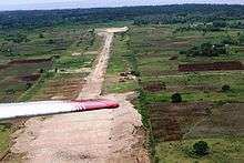
There is a small rolled-earth airstrip on Pacijan island. It is approximately 900 metres (3,000 ft) long, aligned more or less north-south.[lower-alpha 2] It has not been classified by the CAAP, hence has no airport code, however following a visit to the area by President Aquino in February 2014, investigations are taking place into developing the airport as a prerequisite to expanded tourism.[4][5]
In February 2015 it was reported that initial work was under way on the construction project to build new airports at Bantayan and Camotes.[6][7] The initial project phase is to determine a suitable location for the new airport, implying that it may be at an entirely different location on the islands
Environment
Demographics
|
10,000
20,000
30,000
40,000
50,000
60,000
70,000
80,000
90,000
100,000
1990
1995
2000
2007
2010
|
| ||||||||||||||||||||||||||
Climate
Tropical monsoon climate (Köppen climate classification category "Am"), with rainfall more or less evenly distributed throughout the year – Coronas climate type IV.
Biota
By Presidential Proclamation 2152 of 1981, the islands of Ponson, Poro and Pacihan were declared Mangrove swamp forest reserves.[10]
Exemplars of the rare, critically endangered tree species Cebu Cinnamon (Cinnamomum cebuense) have been discovered on the Camotes Islands.[11][12]
Palm trees are the dominant plant on the islands. There are also numerous native varieties of fruit including banana, mango and pineapple.
History
Protohistory
Little is known of the islands' early history. The twentieth century saw a number of archaeological studies, but nothing of major significance emerged.
An early visitor was Carl Guthe, who led an expedition from the University of Michigan which spent three years 1923–1925 investigating and exploring many sites across the archipelago.[13] He conducted an archaeological dig in a cave site on Tulang. Located on the southeastern coast of the island, the cave measures about 3.7 by 2.7 metres (12 by 9 feet). Guthe reported it to contain bone fragments and teeth of about 60 individuals. Associated grave goods included earthenware pottery, shell bracelets, bronze and iron artefacts (iron tang, bronze chisel, iron blade), glass and stone beads, hammerstone and pestle. Filed teeth were also recovered from this site.[lower-alpha 3]
Otley Beyer (Philippine's "Father of Anthropology") never visited, although he is reported to have described Camotes as a "basket of interesting archaeological finds."
In the early 1970s, residents unearthed a variety of artefacts dating back to the 16th century. An excavation at Mactang, a purok within brgy Esperanza, Poro, revealed spears, daggers, swords, crosses, iron pendants and a skull pierced with an arrowhead. This heavily disturbed and looted site located along the shoreline of sitio Mactang was excavated by Bailen and Cabanilla of U.P. Diliman in the early 1990s and explored by Bersales and USC in 2001. Porcelain and earthenware sherds are strewn on the surface of what would otherwise have been a 13th- or 14th-century CE burial site.
In one barangay, Bailen and Cabanilla found a complex of caves which they believed had been inhabited by primitive people. Cabanilla asked municipal officials to preserve the site and wait while their project proposal would be approved. They planned to conduct a digging and leave whatever artefacts would be found in the caves. Meaning, they would transform the place into an onsite museum that should attract students, archaeologists. etc.
A few months later, Cabanilla returned to Camotes, having secured project funding from a foreign institution. To his surprise, and despite earlier assurances of its safekeeping, he found the caves already mined of stone which had been sold to a sinter plant in Leyte by the mayor. Only one cave remained, but Cabanilla lost the drive and returned to Manila, his project scuttled.
Because of that, even the plan to set up a town museum for the artefacts dug during the survey was abandoned.
Spanish conquistadores
 Pigafetta's Journal of Magellan's Voyage (in French)[14]:77 |
 Pigafetta's Journal of Magellan's Voyage – map showing (top) Bohol, (centre) Mactan, (bottom) Cebu. The three unnamed islands to right must be Camotes.[14]:114 |
The islands were first mentioned by Antonio Pigafetta, one of the survivors on Ferdinand Magellan's fateful voyage, as they waited off the islands for several days before going on to Cebu in the first week of April 1521:
De mazaua agatighan sonno vinti leghe partendone de gatighan al ponente il re de mazaua no ne puote seguir por che lo espectassemo circa tres ysolle cioe polo ticobon et pozon.[15]:108There is a distance of twenty leguas from Mazaua to Gatighan.[lower-alpha 4] We set out westward from Gatighan, but the king could not follow us [closely] and consequently we awaited him near three islands, namely Polo, Ticobon and Pozon.[16]:132–134, 137
Writing in 1582, Miguel de Loarca stated:[16]:48
ysla de camotes. Por la pte del leste de la ysla de çubu esten dos ysletas pequeñas qe ternan de box cada vna çinco leguas que llaman ysletas de camotes ternan entrambas como treçientos yndios son proprios de la çiudad de çubu es gte pobre aunqe tienen alguna çera, y muçho Pescado son las poblaçones pequeñas de siete y a ocho casas estan apartadas de la ysla de çubu como tres leguas y siete de la çiudad—Island of Camotes. East of the island of Çubu are two small islets, each about five leagues in circumference.[lower-alpha 4] They are called the islets of Camotes. The two are inhabited by about three hundred Indians, and are under the jurisdiction of the city of Çubu. The people are poor, although they possess some wax and a great quantity of fish. The villages are small, consisting of only seven or eight houses each. These islets are about three leagues from the island of Çubu, and seven from the city of that name.
He also wrote:[17]:38
- "todos son de vna manera tienen tambien gallinas y puercos y algunas cabras frisoles y vnas Rayçes como batatas de sancto domingo qe llaman camotes
- All are provided with fowls, swine, a few goats, beans, and a kind of root resembling the potatoes of Sancto Domingo, called by the natives camotes."
Modern times
In 1942 Japanese forces occupied Camotes Islands. In 1945 Japanese soldiers massacred almost all of the inhabitants in Pilar which led to a war crimes trial after the war. The liberation of the islands happened soon after the massacre when Philippine and American soldiers landed and fought the remaining Japanese soldiers in the Battle of Camotes Islands.
Economy
The predominant industries on the Camotes Islands are farming (including corn, rice, pigs, chicken and cattle), fishing and tourism.
There are about 22 tourist resorts catering to both domestic and international visitors with many public and private beaches.
Also in the Camotes Islands you can find tourist spots such as Buho Rock, Greenlake Park, Mt. Calvary (Kalbaryo), Lake Danao and the vast mangrove swamp along the sides of the road from Pacijan (San Francisco) to Poro. There are many underground caves such as Bukilat Cave, Timubo Cave and Guadalupe Cave which has a fresh-water underground lake. There are also two waterfalls, one in Poro and one in Tudela. There is diving and snorkeling opportunities at some of the resorts.
The major employers are CELCO (Camotes Electric Cooperative), Camotes Hillside Academy and Kinoshita Pearl Farm. There is a small hospital. Fiesta Mall, the first mall on the island opened in 2015.[lower-alpha 5] A new integrated casino resort with condos is scheduled to open in December, 2016. Tourism in the key economic development for the future of the island with a focus on the white sand beaches, safe and clean environment.
There are two colleges on the island: Cebu Technology University (Camotes) and Mount Moriah College.
Languages
Cebuano is the primary language, then English and Filipino. School children are taught all three languages. Porohanon or Camotes Visayan is spoken in the town of Poro only. The dialect is very similar to the language spoken in the rest of Camotes Islands and throughout the province of Cebu, Northern Mindanao and other parts of the Visayas. Porohanon is distinguished by the way the locals substitute the /y/ sound for /z/. Example: Maayong buntag (good morning) in Cebuano would be changed to Maazong buntag in Porohanon. Na-a diha (in cebuano), Ara dira ( in porohanon )
Notes
- ↑ Presumably a bad-geography allusion to Lost Horizon, 1933 novel by James Hilton, whose principal location was a land where people never aged – Shangri-La
- 1 2

.svg.png) LS PilarLS PoroLS Tulang
LS PilarLS PoroLS Tulang
 ⛴ 1⛴ 2⛴ 3
- ⛯ LS Pilar 10°48′18″N 124°34′00″E / 10.80500°N 124.56667°E
- ⛯ LS Poro 10°37′48″N 124°24′40″E / 10.63000°N 124.41111°E
- ⛯ LS Tulang 10°43′30″N 124°19′00″E / 10.72500°N 124.31667°E
- ⛴ 1 Consuelo
- ⛴ 2 Pilar
- ⛴ 3 Poro
- ✈ Airstrip 10°39′23″N 124°22′12″E
- ↑ Carl Guthe explored 485 sites comprising 120 caves, 134 burial grounds and 231 graves all over the Philippines that are contained in an inventory report now deposited at the University of Michigan.
- 1 2 The league (legua) was not well defined, but was about 4 nautical miles (4.6 miles; 7.4 kilometres) ± 5%
- ↑ unconfirmed report that mall opened October 2014.[18]
References
- ↑ Philippines 2012 Municipality Statistics
- 1 2 Census of Population (2015): Highlights of the Philippine Population 2015 Census of Population (Report). PSA. Retrieved 20 June 2016.
- ↑ "COAST GUARD DISTRICT CENTRAL VISAYAS LIGHTSTATIONS".
- ↑ "President Aquino wants to develop Bantayan airport – Gov. Davide". Philippine News Agency (PNA). 4 July 2014. Archived from the original on 2014-11-06. Retrieved 6 November 2014. External link in
|publisher=(help) - ↑ van den Berg, S.G. (2011). Development of tourism on Camotes Islands, Philippines (PDF) (Thesis). Nederlandse Universiteiten Utrecht. Retrieved 12 November 2014.
- ↑ Braga, Michael Vencynth H. (2 February 2015). "Dev't of Camotes, Bantayan airports on". The Freeman. Archived from the original on 2015-07-20. Retrieved 4 February 2015.
- ↑ Cabahug, Melissa Q. (2 February 2015). "Bantayan, Camotes to have airports". Cebu Daily News. Archived from the original on 2015-02-04. Retrieved 4 February 2015.
- ↑ Census of Population and Housing (2010): Population and Annual Growth Rates for The Philippines and Its Regions, Provinces, and Highly Urbanized Cities (PDF) (Report). NSO. Retrieved 29 June 2016.
- ↑ Census of Population (1995, 2000 and 2007): Population and Annual Growth Rates by Province, City and Municipality (Report). NSO. Archived from the original on 4 February 2012.
- ↑ Presidential Proclamation No. 2152 s. 1981 of 29 December 1981 Declaring the entire province of Palawan and certain parcels of the public domain and/or parts of the country as Mangrove Swamp Forest Reserves. Retrieved 11 November 2014.
- ↑ Basingan; Caspillo; Masauding; Pendon; Racpan (30 August 2012). Philippine Trees – Fruit Trees (Online book). History Trees. p. 44. Retrieved 9 November 2014.
- ↑ "Cebu Cinnamon". Global Trees Campaign. Retrieved 9 November 2014.
- ↑ Guthe 1927.
- 1 2 "Journal of Magellan's Voyage" (in French). World Digital Library. 1525.
This manuscript volume, dating from around 1525, details Ferdinand Magellan's voyage around the world in 1519-22. The work is attributed to Antonio Pigafetta, a Venetian scholar who was born in Vincenza, Italy, around 1490 and who accompanied Magellan on the voyage. Pigafetta kept a detailed journal, the original of which is lost. However, an account of the voyage, written by Pigafetta between 1522 and 1525, survives in four manuscript versions: one in Italian and three in French. This version, in French, is from the library of Yale University, and is the most complete and handsomely produced of the four surviving manuscripts. It includes 23 beautifully drawn and illuminated maps. Pigafetta’s work is important not only as a source of information about the voyage itself, but also includes an early Western description of the people and languages of the Philippines. Of the approximately 240 men who set out with Magellan, Pigafetta was one of only 18 who returned to Spain. Magellan himself was killed, on April 27, 1521, in a battle on Mactan Island, the Philippines, which Pigafetta witnessed and recounts in this work.
- ↑ Pigafetta 1874.
- 1 2 Blair & Robertson Vol 33
- ↑ Blair & Robertson Vol 05.
- ↑ "SOON TO OPEN: GAISANO CAPITAL SAN FRANCISCO". Gaisano Capital Group. 18 August 2014. Retrieved 10 November 2014.
Sources
- Blair, Emma Helen & Robertson, James Alexander, eds. (1903). The Philippine Islands, 1493–1803. Volume 05 of 55 (1582–1583). Historical introduction and additional notes by Edward Gaylord Bourne. Cleveland, Ohio: Arthur H. Clark Company. ISBN 978-0554259598. OCLC 769945704.
Explorations by early navigators, descriptions of the islands and their peoples, their history and records of the catholic missions, as related in contemporaneous books and manuscripts, showing the political, economic, commercial and religious conditions of those islands from their earliest relations with European nations to the beginning of the nineteenth century.
- Blair, Emma Helen & Robertson, James Alexander, eds. (1906). The Philippine Islands, 1493–1898. Volume 33 of 55 (1519–1522). Historical introduction and additional notes by Edward Gaylord Bourne;. Cleveland, Ohio: Arthur H. Clark Company. OCLC 769945723.
Explorations by early navigators, descriptions of the islands and their peoples, their history and records of the catholic missions, as related in contemporaneous books and manuscripts, showing the political, economic, commercial and religious conditions of those islands from their earliest relations with European nations to the close of the nineteenth century.
- Guthe, Carl E. (1927). "THE UNIVERSITY OF MICHIGAN PHILIPPINE EXPEDITION". American Anthropologist. University of Michigan / Blackwell Publishing Ltd. 29 (1): 69–76. doi:10.1525/aa.1927.29.1.02a00040. ISSN 1548-1433.
- Pigafetta, Antonio (1874) [c.1523]. Primo Viaggio Intorno Al Mondo [First Voyage Around the World] (various). translated by Henry Edward John Stanley. London: Hakluyt Society. ISBN 978-0511708046. OCLC 3163468.
Reprinted by Filipiniana Book Guild of Manila, 1969
External links
- Camotes News site
- Mystical Tudela Website
- How to get to Camotes Island
- Camotes Islands Travel Guide
- TourCamotes.Com: All About Camotes Islands, Cebu, Philippines
- Cebu Destinations
- Local government site