Cambridge Common
|
Cambridge Common Historic District | |
|
View of the Cambridge Common, ca. 1808-09, with Harvard College on the left and Christ Church on the right. | |
  | |
| Location | Roughly SE of Waterhouse St., bordered by Garden St. and Massachusetts Ave., Cambridge, Massachusetts |
|---|---|
| Area | 8.5 acres (3.4 ha)[1] |
| Built | 1770 |
| Architectural style | Greek Revival, Federal |
| MPS | Cambridge MRA |
| NRHP Reference # | 87000499[2] |
| Added to NRHP | January 26, 1987 |

Cambridge Common is a public park in Cambridge, Massachusetts, United States. It is located near Harvard Square and borders on several parts of Harvard University. This park is a popular place to play kickball, softball, soccer, and frisbee. The north end of the park has a large playground. The park is maintained by the Cambridge Department of Public Works.[3]


History
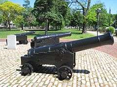
General George Washington gathered troops on Cambridge Common during the American Revolutionary War. A commemorative plaque marks the location of the Washington Elm, a tree under which legend claims Washington stood as he first assumed command of the Continental Army. Nearby is a trio of bronze cannons, a plaque for Henry Knox, and another for Tadeusz Kościuszko.
Slightly southeast of the center of the Common is a memorial to the American Civil War with a statue of Abraham Lincoln in a covered area near the base of the memorial. On top of the memorial is a statue of a soldier.
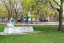
Cambridge Common is also the site of an Irish Famine Memorial, dedicated on July 23, 1997 by then President of Ireland, Mary Robinson, and unveiled to an audience of 3,000 people. The Memorial sculpture was created by Maurice Harron, a sculptor from Derry, Northern Ireland. There is a similar memorial in downtown Boston.
Gallery
 Civil War Memorial
 The Great Hunger in Ireland Memorial
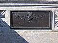 Plaque at entrance: Near this spot on July 3, 1775, George Washington took command of the American Army
 Plaque at entrance: In memory of this event, this gate was erected A.D. October, 1906
 Plaque: Way to Charlestown
 Kemp Playground
 Kemp Playground
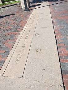 Commemoration of Dawes's ride. Bronze horseshoes embedded in the sidewalk with inscription: "William Dawes to Lexington April 19, 1775" (correct date was April 18)
See also
References
| Wikimedia Commons has media related to Cambridge Common. |
- Cambridge Common Irish Famine Memorial (archived 2007)
- ↑ G. W. Bromley map showing area in square feet
- ↑ National Park Service (2010-07-09). "National Register Information System". National Register of Historic Places. National Park Service.
- ↑ Community Development Department. Public Parks, Playgrounds, and Reservations. August, 2012.
| Topics |  | ||||||||||||||||||||||||||||||
|---|---|---|---|---|---|---|---|---|---|---|---|---|---|---|---|---|---|---|---|---|---|---|---|---|---|---|---|---|---|---|---|
| Lists by county | |||||||||||||||||||||||||||||||
| Lists by city |
| ||||||||||||||||||||||||||||||
| Other lists | |||||||||||||||||||||||||||||||
| |||||||||||||||||||||||||||||||
Coordinates: 42°22′35″N 71°07′14″W / 42.37651°N 71.12049°W