Cambria, California
| Cambria | |
|---|---|
| Census designated place | |
|
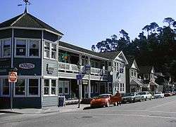
Burton Drive in Cambria's historic East Village | |
 Location in San Luis Obispo County and the state of California | |
| Coordinates: 35°33′15″N 121°5′15″W / 35.55417°N 121.08750°WCoordinates: 35°33′15″N 121°5′15″W / 35.55417°N 121.08750°W | |
| Country |
|
| State |
|
| County | San Luis Obispo |
| Named for | Cambria County, Pennsylvania |
| Area[1] | |
| • Total | 8.508 sq mi (22.037 km2) |
| • Land | 8.508 sq mi (22.037 km2) |
| • Water | 0 sq mi (0 km2) 0% |
| Elevation[2] | 43 ft (13 m) |
| Population (April 1, 2010) | |
| • Total | 6,032 |
| • Density | 710/sq mi (270/km2) |
| Time zone | Pacific (UTC−8) |
| • Summer (DST) | PDT (UTC−7) |
| ZIP code | 93428 |
| Area code | 805 |
| FIPS code | 06-10074 |
| GNIS feature IDs | 1652683, 2407941 |


Cambria /ˈkeɪmbriə/ is a seaside village in San Luis Obispo County, California, United States midway between San Francisco and Los Angeles along California State Route 1 (Highway 1). The name Cambria, chosen in 1869, is the Latin name for Wales. Cambria is situated amidst Monterey pines in one of only three such native forests.[3] Previously, the town had gone by the names of Slabtown, Rosaville, San Simeon and Santa Rosa. The corresponding census designated place (CDP) had a population of 6,032 at the 2010 census, slightly down from 6,232 at the 2000 census.
History
Local tribes
The earliest human settlement of this area is known to be associated with prehistoric habitation by the Native American Chumash peoples, who exploited marine resources along the coastal area, with emphasis upon sites that were close to rivers.[4]
Although our recorded history of the tribes in this region does not begin until the explorers and missionaries arrived, there is evidence of many tribal settlements in the area later known as Cambria. It is estimated that as many as 30,000 people inhabited the area in the time (some 1000 years) before the Spanish arrived. Experts believe these tribes to have been migratory and used Cambria as a seasonal settlement; other scientists are convinced that they lived there permanently. Most agree that they fed themselves with shellfish and seafood, as well as obtaining food from travels inland to hunt and gather seeds. A variety of artistically-crafted implements have been discovered, including spears points and arrowheads made from obsidian; basalt, sandstone, and granite were used to make mortars and pestles; soapstone kettles and stone hammers were also found. These early inhabitants were skilled basket and net makers and fashioned jewelry from crab claws, abalone shells, and the teeth of sharks and whales. The presence of soapstone (steatite) provides evidence that they traded with the Catalina Island tribes, whereas the lack of metals and glass indicates that they did not trade with Europeans or Asians.[5]
According to scientists there is ample evidence to conclude that Cambria tribes were gentle, generous, and peaceful people and that they lived simply. Their family bonds were strong, and they showed great love and patience toward their children. The members of the Cambria tribes were also noted for their extreme cleanliness in handling and preparing food and possessed a marked knowledge of medicinal herbs. For entertainment, they played music and had a passion for gambling.[6]
Early settlers and quicksilver
The first recorded visit by Europeans took place in 1769 when the Portola expedition, coming overland from the south, visited the area. The Spanish explorers camped near the present site of the Coast Union High School, on Santa Rosa Creek, on September 10, 1769, and again on December 24-25, spending the first Christmas in what later became known as Cambria. The Spanish soldiers named the site El Osito, because the local Chumash people offered them a young pet bear (which they politely refused).[7] Gifts of food (pinole and fish) were particularly welcome on their return journey, because food supplies were running short.[8]
Cambria is located on the Rancho Santa Rosa Mexican land grant given in 1841 to Julian Estrada.
Settlers were drawn to the area because of the fertile lands, streams, and lumber. Additionally, miners were attracted to the area by the 1862 discovery of cinnabar, the ore from which quicksilver can be made. For a while, Cambria was a boom town, with $280,000 worth of quicksilver shipped out of San Simeon between 1867 and 1870.[9]
During several years Cambria was a booming mine town, and prospectors flooded the area. More than 150 claims were filed in the early 1870s. The most successful of these claims, the Oceanic Quicksilver Mining Company, at one time employed 300 and was the largest mine in the area and the sixth largest in the world. Three furnaces were built, seven tunnels completed, and their stock price jumped to $30.00 a share. Hopes were high, and Cambria residents dreamed of imminent wealth. Unfortunately, by 1878, mercury prices started to fall and Cambria's first economic boom ended.[10] As mercury prices fluctuated, Cambria's mining thrived and dwindled. During the boom of 1876, $282,832 worth of quicksilver was produced; four years later, production had decreased to only $6,760. A devastating fire in 1889 virtually ended the mercury business and Cambria settled into a quiet dairy community.[11]
Originally an American settlement called Slab Town, the town later known as Cambria was centered at the Leffingwell cove of today's northern Moonstone Beach, which beach also featured a wharf. Because lumber production, ranching activities and mercury mining increased in the area, the village adopted the more dignified name of Cambria. The name as such was contributed by a local surveyor from Cambria County, Pennsylvania, because the local topography and flora reminded him of that place.[12]
A castle and a shipwreck
Cambria has benefited greatly from the building of the Hearst Castle. During the high unemployment years of the Great Depression, many of the Cambria citizens found welcome employment in the building activities. Additionally, Cambria provided supplies, services, and accommodations for many who came to build the Castle, creating prosperity in Cambria in an otherwise not really prosperous decade.[13]
War also affected Cambria when the 8,000-ton Union Oil tanker, SS Montebello, was attacked and sunk in the early morning of December 23, 1941. Cambria citizens rallied to the rescue and all six crewmen were rescued. According to the captain, Olaf Eckstrom, these citizens of Cambria were real heroes: "God Bless 'em — they performed like American seamen, orderly, efficient, without hysteria." [14]
Other notable locations in the town include the historical Old Santa Rosa Chapel which was built in 1870, and as one of the oldest churches in the county of San Luis Obispo, held Catholic mass until May 26, 1963.[15] The church fell into neglect until 1978, when the chapel and cemetery were restored. Wooden markers and tombstones as old as the founding year of the chapel (1870) grace the Santa Rosa Catholic Cemetery to the rear of the small chapel; at the entrance there is a large sign reading: In Pace Requiescat (Latin for Rest In Peace).[16]
Geography
Cambria is located at 35°33′15″N 121°05′15″W / 35.554030°N 121.087394°W.[17] According to the United States Census Bureau, the CDP has a total area of 8.5 square miles (22 km2), all of it land.
Demographics
2010
The 2010 United States Census[18] reported that Cambria had a population of 6,032. The population density was 708.9 people per square mile (273.7/km²). The racial makeup of Cambria was 5,166 (85.6 %) White, 18 (0.3 %) African American, 47 (0.8 %) Native American, 78 (1.3 %) Asian, 14 (0.2 %) Pacific Islander, 557 (9.2 %) from other races, and 152 (2.5 %) from two or more races. Hispanic or Latino of any race were 1,187 persons (19.7 %).
The Census reported that 6,031 people (100 % of the population) lived in households; only 1 (0 %) was known to live in non-institutionalized group quarters, and none were institutionalized.
There were 2,762 households, out of which 442 (16.0 %) had children under the age of 18 living with them; 1,483 (53.7 %) were opposite-sex married couples living together, 200 (7.2 %) had a female householder with no husband present, 75 (2.7 %) had a male householder with no wife present. There were 130 (4.7 %) unmarried opposite-sex partnerships and 31 (1.1 %) same-sex married couples or partnerships. 804 households (29.1 %) were made up of individuals and 422 (15.3 %) had someone living alone who was 65 years of age or older. The average household size was 2.18 persons. There were 1,758 families (63.6 % of all households); the average family consisted of 2.61 persons.
The population was spread out with 858 people (14.2 %) under the age of 18, 281 people (4.7 %) aged 18 to 24, 865 people (14.3 %) aged 25 to 44, 2,116 people (35.1 %) aged 45 to 64, and 1,912 people (31.7 %) who were 65 years of age or older. The median age was 57.1 years. For every 100 females there were 90.6 males. For every 100 females age 18 and over, there were 88.2 males.
There were 4,062 housing units at an average density of 477.4 per square mile (184.3/km²), of which 1,985 (71.9 %) were owner-occupied, and 900 (28.1 %) were occupied by renters. The homeowner vacancy rate was 3.4 %; the rental vacancy rate was 10.1 %. 4,030 people (66.8 % of the population) lived in owner-occupied housing units and 2,001 people (33.2%) lived in rental housing units.
2000
As of the census[19] of 2000, there were 6,232 people, 2,816 households, and 1,881 families residing in the CDP. The population density was 727.1 people per square mile (280.8/km²). There were 3,752 housing units at an average density of 437.7 per square mile (169.0/km²). The racial makeup of the CDP was 91.08 % White, 0.35 % African American, 0.99 % Native American, 1.16 % Asian, 0.13 % Pacific Islander, 4.03 % from other races, and 2.26 % from two or more races. Hispanic or Latino of any race were 14.02 % of the population.
There were 2,816 households out of which 18.6% had children under the age of 18 living with them, 57.6 % were married couples living together, 7.1 % had a female householder with no husband present; 33.2 % were non-families; 26.8 % of all households were made up of individuals and 13.2 % had someone living alone who was 65 years of age or older. The average household size was 2.21 and the average family size was 2.63 persons.
In the CDP the population was spread out with 16.4 % under the age of 18; 5.4 % from 18 to 24; 18.0 % from 25 to 44; 33.5 % from 45 to 64, and 26.6 % who were 65 years of age or older. The median age was 51 years. For every 100 females there were 91.4 males. For every 100 females age 18 and over, there were 89.5 males.
The median income for a household in the CDP was $ 45,000, and the median income for a family was $ 55,745. Males had a median income of $ 36,193 versus $ 24,594 for females. The per capita income for the CDP was $ 29,620. About 8.3 % of families and 8.2 % of the population were below the poverty line, including 15.6 % of those under age 18 and 4.5 % of those age 65 or over.
Tourism
The primary economic activity of Cambria is tourism. Located on the Pacific Ocean, the area has rocky cliffs and beaches. The town and adjacent hills are known for the extensive Monterey pines that give the area a particular character. Tragically the 2012–14 drought devastated the forests with estimates that as many as 40% of the trees were dying.[3]
There are many bed and breakfast inns and hotels, especially along Moonstone Beach Drive.The beach is home to various sea life such as seals and sea otters and tide pools filled with sea anemones, sea urchins, star fish, crabs, snails and more. The beach was named after the moonstones that wash ashore there. Moonstone Beach Boardwalk is a 1.5 mi (2.4 km) walk with several beach access points and benches to allow for sea life observation and beach combing.
Hearst Castle is located approximately six miles north, and the Northern elephant seal rookery at Piedras Blancas is some fifteen miles to the north.
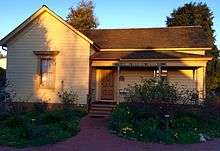
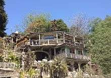
Cambria is home to the Cambria Historical Museum in the historic East Village and to the California State Historical Landmark No 939, Nitt Witt Ridge.[20][21]
Parks and recreation

Cambria offers a variety of recreational activities such as bicycling and hiking. Local beaches offer a venue to boogie board, surf, and skimboard. Ocean fishing is conducted off area beaches. Local kayak fishing tours are available.
Protected areas
The Fiscalini Ranch Preserve (formerly known as the East-West Ranch) is a 430-acre park that separates Cambria's East and West Villages; it protects over a mile of spectacular Pacific Ocean coastline. The Fiscalinis were pioneering Italian Swiss dairymen, who moved into the Cambria region in the 1880s; they acquired a number of dairy farms, including what they called the Town Ranch. The Fiscalini family donated small plots of the Town Ranch as building sites for the Cambria public library, the Veterans Memorial and a museum. By the 1970s, the Fiscalini heirs, facing an inheritance tax of over one million dollars, sought a buyer, preferably a non-profit organization. None came forth, and in 1979 they sold the property to a developer, who went bankrupt in 1989 after failing to win approval of his ambitious development plans. The Fiscalini property was then sold for three million dollars to wealthy investors in the early 1990s. However, their development plans were also rejected, and in 2000 they sold the property to the American Land Conservancy. The park is managed by the Cambria Community Services District.[22][23]
Marine protected areas
Cambria State Marine Conservation Area and White Rock (Cambria) State Marine Conservation Area are marine protected areas off the coast of Cambria. Much like other underwater parks, the marine protected areas help conserve ocean wildlife and marine ecosystems.
Geology
Cambria is built on the Cambria Slab, a 5,000 ft. thick late-Cretaceous sandstone in a rather enigmatic geologic setting, completely surrounded by Franciscan Formation rocks, mostly mélange. The Cambria Slab extends from Villa Creek in Estero Bluffs State Park to San Simeon Creek, holding up the high coastal ridge between Cayucos and San Simeon State Park. The sandstones are massively bedded. Bedding is only occasionally visible, as at the Leffingwell Landing bridge on Moonstone Beach. Compositionally, they are a feldspathic graywacke. The rocks in places are distorted and sheared (for example, below the high bluff at the north end of Moonstone Beach), and in a few areas injected by Franciscan mélanges and serpentinites (as on the beach below the high bluff at the north end of the Bluff Trail in the Fiscalini Ranch preserve). The Slab was deposited in an area of active subduction during the plate-tectonic assembly of today's coastal California.[24]
Government
In the state legislature Cambria is in the 17th Senate District, represented by Democrat Bill Monning, and in the 35th Assembly District, represented by Republican Jordan Cunningham.[25]
In the United States House of Representatives, Cambria is in California's 24th congressional district, represented by Democrat Lois Capps.[26]
Education
Cambria is home to the Coast Unified School District. The Coast Unified has one K-5 elementary school, one 6-8 middle school, one traditional 9-12 high school, Coast Union High School, and one alternative high school. The District also serves the communities of San Simeon to the North and Cayucos to the South (grades 9-12) as well as the surrounding rural areas.
Coast Union High School
Coast Union High School, home of the Broncos, is a very small public high school located on the farmland of Cambria. It typically enrolls around 230 students, all active in FFA, school clubs, athletics, and many other school activities.
Athletics
Although known for its very small enrollment, Coast Union does perform well in sports. The girls' volleyball team has won three CIF Championships, the most recent being 2011. The school has at least one championship in almost all of the sports provided, and have won numerous league championships. Every year, all sports are put up against the top schools in the county, and perform well, winning more often than not.
Infrastructure
The community gets its water supply from wells that tap San Simeon and Santa Rosa creeks. The area is vulnerable to shortages due to the reliance on an unstable network of creeks, lakes and State Water Project allocations. The Cambria Community Services District is building a treatment plant to treat brackish water and return it to the aquifer. The water is a combination of groundwater, percolated wastewater treatment plant effluent and a mix of fresh water and salt water. The $9.13-million water treatment plant is controversial as critics contend it will damage the delicate ecosystem, particularly San Simeon Creek lagoon, and burden ratepayers for years.[3]
In popular culture
The small town and high school were used for the filming of the 1990 hit, Arachnophobia. The filmmakers didn't use the town name however, and went with the name Canaima. The football players and staff shown on the field and in group events were actual CUHS students and staff, and the locker room, gymnasium, and surrounding buildings seen in the film are actual buildings of the high school.
The town became the basis for the hit radio drama "Milford-Haven U.S.A" that aired first locally in Cambria and San Luis Obispo, and also in Rochester, New York from 1987 to 1990. In 1992, it became a hit on BBC Radio, the first American radio serial broadcast in the U.K. where it reached an audience of 4.5 million listeners. In the 2000s it became a series of best-selling books called The Milford-Haven Novels.
Cambria is the setting for the romance novel Moonstone Beach by Linda Seed.
Notable people
- Red Holloway, saxophonist[27]
- Peter Horton, actor, producer
- Catherine Ryan Hyde, author[28]
- Jude Johnstone, singer-songwriter
- Shia LaBeouf, actor
- S.J. Main, writer, filmmaker
- Nehemiah Persoff, actor
- Charlie Shoemake, vibraphonist[29]
- Kath Soucie, cartoon voice actress
- Arthur Tress, photographer
References
- ↑ "2010 Census U.S. Gazetteer Files – Places – California". United States Census Bureau.
- ↑ "Cambria". Geographic Names Information System. United States Geological Survey. Retrieved November 9, 2014.
- 1 2 3 Covarrubias, Amanda (November 4, 2014) "In Cambria, rift over water treatment plant is a drain on parched town" Los Angeles Times
- ↑ C.Michael Hogan (2008) Morro Creek, The Megalithic Portal, ed. by A. Burnham
- ↑ Baker, Gay Cambria" HarborTown Histories, Santa Barbara, CA, 2003, p. 7-8 ISBN 0-9710984-2-5 (print), 978-0-9879038-2-2 (on-line)
- ↑ Baker, p. 8.
- ↑ Bolton, Herbert E. (1927). Fray Juan Crespi: Missionary Explorer on the Pacific Coast, 1769-1774. HathiTrust Digital Library. pp. 187–188, 258–259. Retrieved April 2014. Check date values in:
|access-date=(help) - ↑ Paul Squibb, 1984, Captain Portola in San Luis Obispo County in 1769. Morro Bay, Tabula Rasa Press, ISBN 0-9319430-0-0
- ↑ Baker, p. 28.29
- ↑ Baker, p. 30-31.
- ↑ Baker, p.41-43
- ↑ Cambria Historical Society - Local History
- ↑ Baker, p. 72-73
- ↑ Baker, p. 77-80.
- ↑ Dunlap, Dawn. "Old Santa Rosa Chapel". Old Santa Rosa Chapel.
- ↑ Blum, Beverly. "Brief History of Santa Rosa Catholic Cemetery". Santa Rosa Catholic Cemetery.
- ↑ "US Gazetteer files: 2010, 2000, and 1990". United States Census Bureau. 2011-02-12. Retrieved 2011-04-23.
- ↑ "2010 Census Interactive Population Search: CA - Cambria CDP". U.S. Census Bureau. Retrieved July 12, 2014.
- ↑ "American FactFinder". United States Census Bureau. Archived from the original on September 11, 2013. Retrieved 2008-01-31.
- ↑ http://cambriahistoricalsociety.com/ Cambria Historical Society
- ↑ Fodor's (December 21, 2010). Fodor's Northern California 2011: With Napa, Sonoma, Yosemite, San Francisco & Lake Tahoe. Random House Digital, Inc. p. 86. ISBN 978-1-4000-0503-1. Retrieved December 25, 2011.
- ↑ Gayle Baker, 2003: Cambria, a history. ISBN 978-0971098428
- ↑ Visiting the Fiscalini Ranch Preserve
- ↑ David Chipping, 1987, Geology of San Luis Obispo County, privately published. Available at San Luis Obispo County public libraries.
- ↑ "Statewide Database". UC Regents. Retrieved January 8, 2015.
- ↑ "California's 24th Congressional District - Representatives & District Map". Civic Impulse, LLC. Retrieved September 29, 2014.
- ↑ http://www.redholloway.com/index.htm
- ↑ "Catherine Ryan Hyde Author Bookshelf". Random House. Retrieved March 11, 2015.
- ↑ Talsan Music | Charlie Shoemake's Biography
External links
| Wikimedia Commons has media related to Cambria, California. |
| Wikivoyage has a travel guide for Cambria, California. |
- Visit Cambria - all things Cambria, from the Cambria Tourism Board
- About Cambria - get informed, get involved
- Cambria History
Municipalities and communities of San Luis Obispo County, California, United States | ||
|---|---|---|
| Cities | 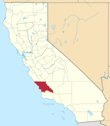 | |
| CDPs | ||
| Unincorporated communities | ||
| Ghost towns | ||