California State Route 90
| ||||
|---|---|---|---|---|
 | ||||
| Route information | ||||
| Defined by Streets and Highways Code § 390 | ||||
| Maintained by Caltrans | ||||
| Length: |
15.50 mi[1] (24.94 km) includes unconstructed portions | |||
| Existed: | 1964 renumbering[2] – present | |||
| Western segment | ||||
| Length: | 3.28 mi[1] (5.28 km) | |||
| West end: |
| |||
| Major junctions: |
| |||
| East end: | West Slauson Avenue in Culver City | |||
| Eastern segment | ||||
| West end: | Vermont Avenue in West Athens | |||
| Major junctions: |
| |||
| East end: |
| |||
| Highway system | ||||
| ||||

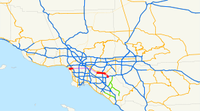
State Route 90 (SR 90) is a state highway in Southern California, United States. It consists of two unconnected pieces in Greater Los Angeles.
The Marina Freeway segment is a short freeway in southwestern Los Angeles and the nearby suburbs, linking Marina del Rey to the rest of Greater Los Angeles. The limited-access portion runs from Slauson Avenue in southern Culver City to just past Culver Boulevard, where it forms the approximate border between the Del Rey and Westchester neighborhoods of the city of Los Angeles. The route continues westward into unincorporated Marina del Rey as an expressway, terminating at Lincoln Boulevard.
The eastern portion of Route 90 is Imperial Highway connecting La Habra, Brea, Yorba Linda and Anaheim Hills. The part in Yorba Linda was relinquished in 2002, and the portion built to freeway standards is now known by two names: The Richard M. Nixon Parkway between Yorba Linda Blvd. and Kellogg Drive, and the Richard M. Nixon Freeway between Kellogg Drive and its southern terminus at Orangethorpe Avenue. It is named in honor of Richard Nixon, the 37th President of the United States, who was born and lived in Yorba Linda.
Route description
This route is part of the California Freeway and Expressway System.[3]
The west segment of SR 90 begins at Lincoln Boulevard (State Route 1) in the Del Rey district of Los Angeles. It heads east along the Marina Expressway, past several intersections, and becomes the Marina Freeway after crossing Ballona Creek. After two interchanges - with Centinela Avenue and Interstate 405 - SR 90 and the freeway end at Slauson Avenue.
The east segment begins at the intersection of Imperial Highway and Beach Boulevard (State Route 39) in La Habra. It heads east and southeast on Imperial Highway, ending at State Route 91 about 1/4 mile (400 m) after crossing the Santa Ana River from Yorba Linda into Anaheim. A portion of the road in Yorba Linda is built to freeway standards; it is now known as the Richard M. Nixon Parkway after the city accepted maintenance in 2002.[2] However, the same state law that authorized relinquishment required the city to "maintain signs directing motorists to the continuation of Route 90".
There were once plans to connect the two sections via the Slauson Freeway and Yorba Linda Freeway, mostly parallel to Slauson Avenue, but this was never built. The full route was added to the California Freeway and Expressway System in 1959.[2]
History
Legislative Route 221 (the Slauson Freeway, now the Marina Freeway) was defined in 1947 to run from pre-1964 Legislative Route 60 (now State Route 1) east to pre-1964 Legislative Route 165 (now Interstate 110). A 1959 extension took it east to pre-1964 Legislative Route 170 (now Interstate 605).[4]
To the east, Legislative Route 176 (the Yorba Linda Freeway, now also the Marina Freeway) was defined in 1939 from pre-1964 Legislative Route 62 (now State Route 39) east and southeast to pre-1964 Legislative Route 43 (now State Route 91). A 1959 extension took it west to pre-1964 Legislative Route 174 (later State Route 42) near Norwalk.[5]
In the 1964 renumbering, LR 221 was assigned State Route 90, but LR 176 all became part of State Route 42, along with the connecting LR 174 to the west. The piece of LR 176 between I-605 and SR 39 was reassigned to SR 90 in 1965, and the rest east to SR 91 became part of SR 90 in 1968 (at the same time as SR 42 became Interstate 105).
Originally planned as the Slauson Freeway, Route 90 was slated to extend across southern Los Angeles County and northern Orange County, ending at the Riverside Freeway in eastern Anaheim. However, by the 1960s, community opposition had reduced it to what is effectively a minor spur of I-405 to Marina Del Rey (derisively dubbed the "Slauson Cutoff" by comedian Johnny Carson). It was renamed the Richard M. Nixon Freeway for a brief period in the early 1970s, but after Nixon's resignation in the wake of the Watergate scandal, its name was changed to the current appellation.
From I-405 west to Centinela Avenue, the Marina Freeway is 8 lanes wide, before it quickly narrows to 4 lanes at the Culver Boulevard exit. The freeway ends approximately 1/2 mile west of Culver Boulevard, and continues as an expressway. There has been talk of extending the Marina Expressway slightly west of Lincoln Boulevard (Route 1) to Admiralty Way (approximately 1/4 mile) to accommodate ongoing expansion of the Marina Del Rey area. Strong opposition to this makes actualization of this plan uncertain.
In 2002 the City of Yorba Linda assumed responsibility for Imperial Highway within its city limits due to AB 887; it lost its state route designation, and is now called the Richard M. Nixon Parkway.
By 2005, construction on the western end of the Marina Freeway began, to extend the freeway terminus from Culver Boulevard to approximately 1/2 mile west of Culver Boulevard by building a full interchange at Culver. The freeway extension was completed in early 2007. The freeway extension also allows Route 90 drivers to avoid a traffic signal at Alla Road (just west of Culver Boulevard.). After the end of the freeway, a pair of frontage roads operating as an expressway continues as Route 90 up to Route 1 (Lincoln Boulevard). Signalized intersections occur at Mindanao Way and Lincoln Boulevard, which is the end of the expressway in Marina del Rey. The reason for the extension is to relieve traffic congestion on surface streets.
Major intersections
Except where prefixed with a letter, postmiles were measured on the road as it was in 1964, based on the alignment that existed at the time, and do not necessarily reflect current mileage. R reflects a realignment in the route since then, M indicates a second realignment, L refers an overlap due to a correction or change, and T indicates postmiles classified as temporary (for a full list of prefixes, see the list of postmile definitions).[6] Segments that remain unconstructed or have been relinquished to local control may be omitted. The numbers reset at county lines; the start and end postmiles in each county are given in the county column.
| County | Location | Postmile [6][7][8] | Exit [9] | Destinations | Notes | ||
|---|---|---|---|---|---|---|---|
| Los Angeles LA 0.92-T3.28 | Los Angeles | 0.92 | West end of SR 90 | ||||
| 1.20 | Mindanao Way | ||||||
| | West end of freeway | ||||||
| 1.75 | Culver Boulevard | ||||||
| R1.72 | 1 | Centinela Avenue | |||||
| Culver City | 2.65 | 2 | No access from SR 90 west to I-405 south; former SR 7; I-405 exit 50B | ||||
| | Sepulveda Boulevard | Eastbound entrance only | |||||
| T3.28 | Slauson Avenue | At-grade intersection | |||||
| Gap in route | |||||||
| Orange ORA 0.50-12.83 | La Habra | 0.50 | |||||
| 2.50 | Harbor Boulevard – Fullerton | Former US 101 / SR 72 | |||||
| Brea | 4.39 | Brea Boulevard | |||||
| 5.19 | State College Boulevard | ||||||
| Fullerton–Brea line | R5.45 | Interchange; SR 57 exit 9 | |||||
| Brea | | Kraemer Boulevard – Placentia | |||||
| 7.27 | |||||||
| Yorba Linda | 11.15 | Kellogg Drive | Interchange | ||||
| 11.50 | East end of state maintenance | ||||||
| Anaheim | 12.03 | West end of state maintenance | |||||
| 12.27 | Orangethorpe Avenue, Esperanza Road | Interchange | |||||
| 12.83 | Interchange; east end of SR 90; SR 91 exit 36 | ||||||
| 12.83 | Imperial Highway | Continuation beyond SR 91 | |||||
| 1.000 mi = 1.609 km; 1.000 km = 0.621 mi | |||||||
References
| Wikisource has original text related to this article: |
- 1 2 January 1, 2006 California Log of Bridges on State Highways
- 1 2 3 California Highways: State Route 90
- ↑ CA Codes (shc:250-257)
- ↑ California Highways: Pre-1964 Legislative Route 221
- ↑ California Highways: Pre-1964 Legislative Route 176
- 1 2 California Department of Transportation. "State Truck Route List". Sacramento: California Department of Transportation. Archived from the original (XLS file) on June 30, 2015. Retrieved June 30, 2015.
- ↑ California Department of Transportation, Log of Bridges on State Highways, July 2007
- ↑ California Department of Transportation, All Traffic Volumes on CSHS, 2011
- ↑ California Department of Transportation, California Numbered Exit Uniform System, State Route 90 Freeway Interchanges, Retrieved on 2009-02-07.
External links
| Wikimedia Commons has media related to California State Route 90. |
- California @ AARoads.com - State Route 90
- Caltrans: Route 90 highway conditions
- California Highways: SR 90
- California Consumers Against the State Route SR 90 Extension