Interstate 710
| ||||
|---|---|---|---|---|
| Long Beach Freeway | ||||
 | ||||
| Route information | ||||
| Defined by Streets and Highways Code § 622 | ||||
| Maintained by Caltrans | ||||
| Length: | 23 mi (37 km) | |||
| History: | 1930s as highway, 1964 as a number (SR 7), 1983-1984 as an interstate (I-710)[1] | |||
| Component highways: |
| |||
| Main section | ||||
| South end: |
| |||
| Major junctions: |
| |||
| North end: | Valley Boulevard in Alhambra | |||
| Pasadena stub | ||||
| South end: | California Boulevard in Pasadena | |||
| North end: |
| |||
| Location | ||||
| Counties: | Los Angeles | |||
| Highway system | ||||
| ||||
.svg.png)

Route 710 (colloquially referred to as "The Seven-Ten"), consisting of State Route 710 (SR 710) and Interstate 710 (I-710), is a state highway in the Los Angeles area of the U.S. state of California, mostly built to interstate standards.
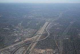
Interstate 710 is a north–south auxiliary interstate freeway running for 23 miles (37 km) through Los Angeles County, California. Officially known as the Long Beach Freeway, it runs north from Long Beach to Valley Boulevard, just north of I-10, the San Bernardino freeway, near the boundary between the cities of Alhambra and Los Angeles. South of I-5, Interstate 710 follows the course of the Los Angeles River, rarely wandering more than a few hundred feet from the riverbed. South of SR 1 in Long Beach, SR 710 is officially part of the Seaside Freeway.[2]
Also called the Los Angeles River Freeway prior to November 18, 1954,[3] I-710 was initially planned to run all the way north to Pasadena, but construction of the segment from Alhambra to Pasadena through South Pasadena has been delayed for several decades due to community opposition. Until this gap is constructed, the segment already completed from California Boulevard north to its northern terminus at State Route 134 and Interstate 210 remains unsigned.
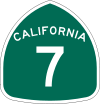
Prior to 1983, the road was not an Interstate, although it was built to Interstate standards. Until 1964 it was State Route 15, but it was renumbered to State Route 7 in the 1964 renumbering because of the existence of Interstate 15, and to I-710 in 1983. The route is part of the California Freeway and Expressway System.[4]
Route description

Section 622 of the California Streets and Highways Code defines Route 710 as "from Route 1 to Route 210 in Pasadena." Section 622.1 amends the definition, stating "Route 710 shall also include that portion of the freeway between Route 1 and the northern end of Harbor Scenic Drive, that portion of Harbor Scenic Drive to Ocean Boulevard, that portion of Ocean Boulevard west of its intersection with Harbor Scenic Drive to its junction with Seaside Boulevard, and that portion of Seaside Boulevard from the junction with Ocean Boulevard to Route 47."[5]
The southern terminus of the freeway presently signed as Interstate 710 is at Ocean Boulevard in Long Beach. From there, the Long Beach Freeway follows the course of the Los Angeles River to Atlantic Boulevard in the city of Bell. 710 then travels roughly north, east of downtown Los Angeles, to its current northern terminus at Valley Boulevard (just north of Interstate 10) in Alhambra and the El Sereno neighborhood of Los Angeles.
Near its southern terminus, I-710 separates into three spur freeways. The first spur splits at the 9th Street interchange, with the left-branching ramps crossing the Los Angeles River and becoming West Shoreline Drive as they head to downtown Long Beach, passing the Aquarium of the Pacific and the Long Beach Convention Center among other attractions. This spur becomes a surface arterial at the intersection with South Chestnut Place and the Pike Parking Garage. Meanwhile, the main segment continues south as the Seaside Freeway, keeping the I-710 designation, until the interchange with Ocean Blvd., where offramps to Ocean Blvd. west carry both the Seaside Freeway name and I-710 designation to the approaches to the Gerald Desmond Bridge. The mainline continues south as Harbor Scenic Drive, leading to the eastern piers of the Port of Long Beach and the Queen Mary. Currently, the Interstate 710 designation terminates at the interchange with SR-47, while the actual roadway and Seaside Freeway designation continue over a bridge towards the Vincent Thomas Bridge.
There is a part of 710 in Pasadena that is constructed to freeway standards, extending from California Boulevard north to the Foothill (I-210)/Ventura (Hwy 134) freeway interchange. However, the route designation on this freeway stub is unsigned, and is instead marked as if it were merely freeway entrance and exit ramps to and from 210.
History

1930–65
Legislative Route 167 was defined in 1933 to run from San Pedro east to Long Beach and north to Monterey Park.[6] An extension was added in 1947, taking it north to Pasadena.[7] State Route 15 was signed in 1934 along the section of Legislative Route 167 from Pacific Coast Highway (State Route 3, later U.S. Route 101 Alternate, now State Route 1) in Long Beach north to Garvey Avenue (U.S. Route 99, replaced by Interstate 10) in Monterey Park. The original pre-freeway alignment ran along Los Robles Avenue (Pasadena) and Atlantic Boulevard.[1][8] The freeway replacement of SR 15/LR 167 was built from 1953 to 1965.[9] The whole route of LR 167, including the proposed extensions west to San Pedro and north to Pasadena, was renumbered State Route 7 in 1964, after it was decommissioned from portions of the San Diego Freeway (which is now Interstate 405) as part of the state highway renumbering, as the number 15 conflicted with Interstate 15. In 1965 the route was truncated to State Route 1 in Long Beach; the part from SR 1 south and west to State Route 47 was deleted, and the rest from SR 47 west to State Route 11 (now Interstate 110) became part of SR 47.
1965–present
The Long Beach Freeway was approved as a chargeable interstate in September 1983, so Caltrans replaced the SR 7 signs with Interstate 710 signs in 1984. It was added shortly after the Harbor Freeway went up, replacing the SR 11 signs with Interstate 110 in 1981.[10] The short stub in Pasadena was built in 1975, along with the adjacent sections of Interstate 210 and State Route 134.[9] There are still remaining overhead street signs pointing motorists to State Route 7 on Ford Boulevard in Monterey Park.[11]
The existing freeway from SR 1 south to Ocean Boulevard was taken over by the state on August 25, 2000, in a trade with the City of Long Beach for former State Route 103 north of SR 1.[12] In 2013, Caltrans adopted the remainder of the Seaside Freeway from Ocean Boulevard to SR 47 over the Gerald Desmond Bridge as part of Route 710. Caltrans and the Port of Long Beach plan to replace the Gerald Desmond Bridge by 2016.[13]
Future
I-710 Corridor Project
The significant growth of cargo volumes handled at the Ports of Los Angeles and Long Beach has added a large amount of truck traffic to the Long Beach Freeway, since it is the most direct route between the port complex and the railyards in Vernon and East Los Angeles, as well as the Pomona and San Bernardino freeways that connect Los Angeles to railyards in San Bernardino and Colton. The freeway's pavement has been badly damaged as a result, since it was not designed to carry nearly as large of a load of truck traffic. It has also become a major source of air pollution, emanating from diesel-fueled trucks idling in rush-hour traffic congestion and giving cities along its route some of the worst air quality in already smoggy Southern California.[14] In response, an Environmental Impact Statement/Environmental Impact Report is currently being conducted to analyze possible significant improvements to I-710 between the Ports of Long Beach and Los Angeles and the Pomona Freeway (SR-60).[15]
The South Pasadena Gap
Overview
The planned segment from Alhambra to Pasadena through South Pasadena has been subject to legal battles which have stopped construction.[16] Because of these legal disputes, the freeway's northern terminus has been Valley Boulevard since the 1960s. However, a short unsigned freeway does exist in Pasadena, heading south from the interchange of Interstate 210 and State Route 134 to California Boulevard. This freeway was supposed to be the northern terminus of I-710. There is a sign on a carpool lane exit on I-210 that marks this unsigned freeway as I-710.
As a result of the route's incomplete condition, freeway signs are inconsistent in their identification of the northbound Long Beach Freeway's destination, with some indicating Pasadena as a control city and others identifying Valley Boulevard as the freeway's terminus. For example, approaching I-710 from State Route 60 (Pomona Freeway) in East Los Angeles, westbound traffic is given Valley Boulevard as the destination for northbound I-710, while eastbound traffic is given a destination of Pasadena. Signs at the interchange with Interstate 105 show Pasadena as the destination for northbound I-710.
Currently, traffic headed for Pasadena on I-710 is redirected to Interstate 10 (San Bernardino Freeway) eastbound by signs at the interchange between the two routes in Monterey Park. These signs identify both Pasadena and San Bernardino as control cities for the eastbound San Bernardino Freeway, although it does not actually pass through Pasadena. Rather, traffic to the city is directed to take State Route 19 (Rosemead Boulevard) northbound from its junction with I-10 (about 6 miles (9.7 km) east of the Long Beach Freeway) to reach Pasadena. Traffic from northbound I-710 is routed onto Fremont Avenue in Alhambra and South Pasadena, and the Pasadena Freeway (State Route 110).
The areas around I-710, northeastern Los Angeles and the northwestern San Gabriel Valley are subject to traffic congestion. There are no completed north–south freeways in the twelve-mile area between Interstate 5 (Golden State Freeway) and Interstate 605 (San Gabriel River Freeway). Pro- and anti-710 lobbies have debated whether finishing I-710 would alleviate any of the San Gabriel Valley's traffic congestion, or merely displace it from surface streets to the freeway.
Current plans
Caltrans and its local partner, the Los Angeles County Metropolitan Transportation Authority (Metro), are researching the possibility of extending the Long Beach Freeway from Valley Boulevard to Pasadena by building a bored tunnel under Alhambra, El Sereno, and South Pasadena. The premise is that a tunnel would allow Caltrans to extend the freeway without disturbing the residential neighborhoods on the surface, similar to other tunnels throughout the world.[16] The proposed twin 4.5-mile-long tunnels would be the longest in the United States, but are small compared with others around the world. Between January and May 2009, Caltrans conducted soil samples for the tunneling project in the Pasadena area and is currently in the process of completing a combined environmental impact statement (EIS) and environmental impact report (EIR), in which the tunnel is one option.[17]
In August 2012, Metro narrowed down the list of potential alternatives to study in the EIR/EIS process. The alternatives include: (1) a no-build alternative, where no additional infrastructure would be built to address the gap in the freeway plan between Valley Boulevard and I-210; (2) a roadway tunnel without exits to connect the northern terminus of the freeway at Valley Boulevard to Pasadena; (3) a light rail line connecting East L.A. with Pasadena using a route that travels along the I-710 right of way until Valley Boulevard where it would become a subway until connecting with the Metro Gold Line at the Fillmore Metro station in Pasadena; (4) a bus rapid transit line from Montebello to Pasadena; and (5) Transportation System Management/Transportation Demand Management (TSM/TDM).[18][19]
Exit list
Except where prefixed with a letter, postmiles were measured on the road as it was in 1964, based on the alignment that existed at the time, and do not necessarily reflect current mileage. R reflects a realignment in the route since then, M indicates a second realignment, L refers an overlap due to a correction or change, and T indicates postmiles classified as temporary (for a full list of prefixes, see the list of postmile definitions).[20] Segments that remain unconstructed or have been relinquished to local control may be omitted. The entire route is in Los Angeles County.
| Location | Postmile [20][21][22] | Exit[23] | Destinations | Notes | |||
|---|---|---|---|---|---|---|---|
| Long Beach | | South end of I-710 | |||||
| | |||||||
| | Pier T Avenue – Piers S T | Northbound entrance only; southbound exit demolished for bridge construction | |||||
| | Gerald Desmond Bridge over Cerritos Channel | ||||||
| | Southbound 710 Freeway Connector closed for bridge construction.[24] | ||||||
| | Pico Ave | Southbound entrance only; temporary south end of southbound I-710 detour | |||||
| 4.96 | Port of Long Beach, Piers A-J | Northbound exit and southbound entrance | |||||
| 5.46 | 1A | Queen Mary (Harbor Scenic Drive) – Piers F-J | Southbound exit and northbound entrance | ||||
| 5.98 | 1B | Pico Avenue – Piers B-E | Southbound exit and northbound entrance; temporary north end of southbound I-710 detour due to closure of connector bridge | ||||
| 6.06 | 1C | Downtown Long Beach, Aquarium (Long Beach Freeway, Shoreline Drive) | Southbound left exit and northbound entrance | ||||
| 6.38 | 1D | Anaheim Street | Signed as exit 1 northbound | ||||
| 6.88 | 2 | Former US 101 Alternate / US 6 | |||||
| 7.89 | 3 | Willow Street | Signed as exits 3A (east) and 3B (west) | ||||
| 9.07 | 4 | Wardlow Road | Southbound exit and northbound entrance | ||||
| 9.41 | 4 | Former SR 7; I-405 exits 32A-B | |||||
| 10.82 | 6 | Del Amo Boulevard | Signed as exits 6A (east) and 6B (west) northbound | ||||
| 12.01 | 7 | Long Beach Boulevard | Signed as exits 7A (south) and 7B (north) southbound | ||||
| 12.89 | 8A | Artesia Boulevard | Northbound exit and southbound entrance | ||||
| 12.97 | 8 | Signed as exits 8A (east) and 8B (west) northbound and the opposite southbound; SR 91 east exits 12A-B, west exit 12A | |||||
| Compton | 13.95 | 9 | Alondra Boulevard – Compton | Signed as exits 9A (east) and 9B (west) southbound | |||
| Paramount | R14.98 | 10 | Rosecrans Avenue | ||||
| Lynwood | R15.69 | 11A | Signed as exit 11 northbound; I-105 exit 13 | ||||
| | 11B | Martin Luther King Jr. Boulevard | Southbound exit and entrance | ||||
| South Gate | 16.99 | 12 | Imperial Highway – Lynwood | Signed as exits 12A (east) and 12B (west) southbound | |||
| 18.44 | 13 | Firestone Boulevard | Former SR 42 | ||||
| Bell | 19.73 | 15 | Florence Avenue – Bell | ||||
| 21.92 | 17A | Atlantic Boulevard, Bandini Boulevard | Signed as exits 17A (north/east) and 17B (south/west) northbound | ||||
| Commerce | 22.45 | 17B | Washington Boulevard – Commerce | Signed as exit 17C northbound | |||
| 23.28 | 18A | Northbound exit and southbound entrance; I-5 south exit 130B | |||||
| 23.28 | 18 | Southbound exit and northbound entrance; I-5 north exit 130C | |||||
| East Los Angeles | 23.77 | 19 | Whittier Boulevard, Olympic Boulevard | Signed as exit 18B northbound; Whittier Boulevard is former US 101 / SR 72 | |||
| 24.47 | 20A | 3rd Street | Signed as exit 20B northbound | ||||
| 24.63 | 20B | Signed as exit 20A northbound; SR 60 exit 3B | |||||
| 24.97 | 20C | Cesar Chavez Avenue | |||||
| Monterey Park | 26.38 | 21 | Ramona Boulevard | Northbound exit and southbound entrance; former US 99 | |||
| 26.50 | 22 | Signed as exits 22A (west) and 22B (east) southbound; north end of I-710; south end of SR 710; I-10 exit 21 | |||||
| Alhambra | T27.48 | 23 | Valley Boulevard | At-grade intersection; former US 60 | |||
| Gap in route | |||||||
| Pasadena | T30.95 | Columbia Street | At-grade intersection | ||||
| T31.76 | California Boulevard | At-grade intersection | |||||
| | South end of freeway | ||||||
| T32.11 | Del Mar Boulevard | Southbound exit and northbound entrance | |||||
| T32.45 | Colorado Boulevard – Pasadena | Southbound exit and northbound entrance; former US 66 Alt. / SR 11 | |||||
| R32.72 | SR 134 exit 13B; northbound exit and southbound entrance. | ||||||
| R32.72 | I-210 east exit 25A; northbound exit and southbound entrance; north end of SR 710. | ||||||
1.000 mi = 1.609 km; 1.000 km = 0.621 mi
| |||||||
South Harbor Scenic Drive spur (exit 1A)
The entire route is in Long Beach, Los Angeles County.
| mi | km | Destinations | Notes | ||
|---|---|---|---|---|---|
| Queen Mary | Southbound exit and northbound entrance | ||||
| Harbor Scenic Drive, Harbor Plaza – Piers H-J | Southbound exit and northbound entrance | ||||
| Harbor Plaza – Port of Long Beach, Piers F-G | Southbound exit only | ||||
| Downtown Long Beach (Queensway Bridge) | Northbound exit and entrance | ||||
| Queensway Drive | Northbound exit and entrance | ||||
| Pico Avenue – Piers F-G | No northbound exit | ||||
| Downtown Long Beach (Ocean Boulevard) | Northbound exit only | ||||
| Northbound exit and southbound entrance | |||||
| 1.000 mi = 1.609 km; 1.000 km = 0.621 mi | |||||
Shoreline Drive spur (exit 1C)
The entire route is in Long Beach, Los Angeles County.
| mi | km | Destinations | Notes | ||
|---|---|---|---|---|---|
| Pine Avenue (Shoreline Drive) – Convention Center, Shoreline Village | Continuation beyond Queensway Bridge | ||||
| Queen Mary, Events Park, Cruise Ships (Queensway Bridge) | At-grade intersection | ||||
| Golden Shore, Catalina Landing | Southbound exit and entrance | ||||
| Ocean Boulevard | Northbound exit and entrance | ||||
| Shoreline Drive | Northbound U-turn | ||||
| Pine Avenue, Broadway – Long Beach Civic Center | Southbound exit and northbound entrance | ||||
| 6th Street east – Downtown Long Beach | Southbound exit and northbound entrance | ||||
| 9th Street, Anaheim Street – Port of Long Beach | Northbound exit and southbound entrance | ||||
| Northbound exit and southbound entrance | |||||
| 1.000 mi = 1.609 km; 1.000 km = 0.621 mi | |||||
See also
-
 California Roads portal
 -
 Greater Los Angeles portal
References
- 1 2 "California Highways: Interstate 710". Cahighways.org. Retrieved 2013-01-26.
- ↑ California State Assembly. "Relating to the Seaside Freeway". 1959 Session of the Legislature. Statutes of California (House Resolution). State of California. Ch. 144 p. 3502.: "That the California Highway Commission is requested to declare the added portion of Route 167 which will connect the Harbor Freeway and the Long Beach Freeway to be a freeway, to be known as the Seaside Freeway..."
- ↑ California Department of Transportation, 2007 Named Freeways, Highways, Structures and Other Appurtenances In California (PDF)
- ↑ "CA Codes (shc:250-257)". Leginfo.ca.gov. Retrieved 2013-01-26.
- ↑ "STREETS AND HIGHWAYS CODE SECTION 300-635". Retrieved 5 October 2014.
- ↑ "California Highways: Chronology of California Highways 1933-1946". Cahighways.org. Retrieved 2013-01-26.
- ↑ "California Highways: Chronology of California Highways 1947-1962". Cahighways.org. Retrieved 2013-01-26.
- ↑ 1942 Gousha Los Angeles map Archived April 24, 2006, at the Wayback Machine.
- 1 2 "January 1, 2006 California Log of Bridges on State Highways". Dot.ca.gov. Retrieved 2013-01-26.
- ↑ "California Highways: State Route 7". Cahighways.org. Retrieved 2013-01-26.
- ↑ "Google Street View of Floral Drive & Ford Boulevard in East Los Angeles, CA of an old overhead sign on a traffic light showing former SR 7". Retrieved 17 July 2016.
- ↑ Caltrans - District 7: A Closer Look At 2000 Achievements (PDF) Archived December 28, 2005, at the Wayback Machine.
- ↑ "Gerald Desmond Bridge - Home". Retrieved 5 October 2014.
- ↑ The Life and Death of Great American Freeways: The 710 Case Study by John Dutton Archived May 17, 2006, at the Wayback Machine.
- ↑ "I-710 Corridor Project Overview". Los Angeles County Metropolitan Transportation Authority. Retrieved 2011-07-16.
- 1 2 "South Pasadena tunnel plan may advance". Los Angeles Times. March 22, 2007. Retrieved 18 Dec 2011.
- ↑ "Metro: SR 710 Conversations Notices and Meeting Materials".
- ↑ "Metro: An Important Announcement Regarding the SR 170 Study" (PDF).
- ↑ "Maps of the alternative routes for the roadway tunnel, light rail, and bus rapid transit alternatives".
- 1 2 California Department of Transportation. "State Truck Route List". Sacramento: California Department of Transportation. Archived from the original (XLS file) on June 30, 2015. Retrieved June 30, 2015.
- ↑ California Department of Transportation, Log of Bridges on State Highways, July 2007
- ↑ California Department of Transportation, All Traffic Volumes on CSHS, 2005 and 2006
- ↑ California Department of Transportation, California Numbered Exit Uniform System, I-710 Northbound and I-710 Southbound, accessed February 2008
- ↑ "NewGDBridge.com. "SB I-710 Freeway Connector Closed."". Retrieved 5 October 2014.
External links
| Wikimedia Commons has media related to Interstate 710 (California). |
- The 710 Freeway Coalition
- The 710 Freeway Fighters
- Friends of Southern California's Highways
- The Life and Death of Great American Freeways: The 710 Case Study by John Dutton
- Long Beach Freeway Gap and Stubs
- AARoads: Interstate 710
- California Highways - Interstate 710
| ||