California State Route 19
| |||||||
|---|---|---|---|---|---|---|---|
 | |||||||
| Route information | |||||||
| Defined by Streets and Highways Code § 319 and 464 | |||||||
| Maintained by Caltrans | |||||||
| Length: |
26.2 mi[1] (42.2 km) (prior to relinquishments) | ||||||
| Existed: | 1934[2] – present | ||||||
| Major junctions | |||||||
| South end: |
| ||||||
|
| |||||||
| North end: |
| ||||||
| Highway system | |||||||
| |||||||

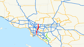
State Route 19 (SR 19), also known as Lakewood Boulevard and Rosemead Boulevard, is a state highway in the Los Angeles area of the U.S. state of California. The route is a north–south four-to-six lane suburban roadway, lying between the Long Beach Freeway (I-710) and San Gabriel River Freeway (I-605), and connecting the eastern parts of Long Beach and Pasadena via the Whittier Narrows. Since 1998, several pieces have been relinquished to local governments, and more transfers are authorized by state law. The portion of SR 19 north of the Whittier Narrows is officially State Route 164, once planned to be upgraded as the Rio Hondo Freeway,[3] but has always been signed as part of SR 19.
Route description
State Route 19
Lakewood Boulevard (no longer SR 19 in Long Beach) begins at the Long Beach Traffic Circle, where State Route 1 (Pacific Coast Highway) heads west and southeast, and Los Coyotes Diagonal heads northeast. It heads north past Interstate 405, passing under a runway of the Long Beach Airport. (The part through the airport has been relocated to the east; parts of the old alignment remain as airport service roads.)
As the Long Beach portion of SR 19 has been relinquished, SR 19 now legally begins at the intersection of Lakewood Boulevard and Del Amo Boulevard, at the southern city limits of Lakewood.[4] SR 19 passes to the west of Lakewood Center Mall before passing through the neighborhood of Mayfair and entering the city of Bellflower. Whereas SR 19 in Bellflower can legally be relinquished by the state to the city, this process has not taken place. SR 19 intersects State Route 91 before straddling the city border between Bellflower and Paramount and later Bellflower and Downey. North of Gardendale Street, SR 19 has been relinquished to the city of Downey.
In Downey, Lakewood Boulevard intersects with Interstate 105 before passing by the large site formerly occupied by North American Aviation, Rockwell International and Boeing Reusable Space Systems and interchanging with Interstate 5. At this latter interchange, Lakewood Boulevard turns into Rosemead Boulevard.[5] Once Rosemead Boulevard crosses Telegraph Road, it enters Pico Rivera, where SR 19 has been relinquished to the city as well.[6] Rosemead Boulevard then continues through Pico Rivera past Pico Rivera Plaza to Gallatin Road.[7]
State Route 164
The 9.56-mile (15.39 km) piece of SR 19 north of Gallatin Road in Pico Rivera has been State Route 164 since the 1964 renumbering, but has always been signed as SR 19. Original plans for SR 164 took it southeast to Interstate 605 from the present transition between SR 164 and SR 19, and it was originally planned as the Rio Hondo Freeway. SR 164 begins as Rosemead Boulevard, leaves the city of Pico Rivera, and enters an unincorporated area.
SR 164 travels across Whittier Narrows Dam before entering the Whittier Narrows Recreation Area and intersecting with the cloverleaf interchange of State Route 60. After this, SR 164 enters South El Monte before crossing the Rio Hondo and straddling the city boundary between Rosemead and El Monte. SR 164 then intersects with Interstate 10 before passing by Rosemead Shopping Center. The next section of SR 164 was relinquished to Temple City in 2008.[8]
Upon leaving Temple City, the maintenance of SR 164 transfers to the county, for this segment of SR 164 has been relinquished.[9] Rosemead Boulevard continues north to Interstate 210. Presently, the north end of the route is at I-210 about a mile south of Sierra Madre Villa Avenue.[7] Originally planned as a freeway, it was to be the intermediate north–south freeway between I-710 (the Long Beach Freeway) and I-605 (the San Gabriel River Freeway). Today, locals generally refer to this road as either Lakewood Boulevard or Rosemead Boulevard, not by its numerical designation. It should be noted that the portion of Rosemead Blvd. between Gallatin Rd. in Pico Rivera and Interstate 10 is built to expressway standards.
Bus service is provided by Metro Local line 266 (between Foothill Boulevard and Del Amo Boulevard) and Long Beach Transit line 111 (south of Del Amo Boulevard) throughout Rosemead Boulevard and Lakewood Boulevard. The Metro Green Line is also provided by a station in the median of Interstate 105 under Lakewood Boulevard.
History
Before the present SR 19 was constructed, San Gabriel Boulevard, which extended from Lamanda Park south to Downey, and was widened and repaved by an assessment tax in 1925,[10] was the main road through the Whittier Narrows, requiring several turns to stay on it and to continue south to Long Beach.[11][12][13] The state legislature added Route 168 to the state highway system in 1933, which followed this general alignment between Route 60 (SR 1) in Long Beach and Route 9 (Foothill Boulevard, then US 66) near Lamanda Park.[14][15]
SR 19 was designated out of the 1964 state highway renumbering. However, since then, many segments of SR 19 have been relinquished to the cities that they run through. Caltrans relinquished Long Beach's portion of SR 19 to the city in 1998,[4] and Downey's segment of SR 19 was relinquished to the city in 2001.[5] However, the segment in Pico Rivera was not relinquished to that city until 2004.[6] In October 2006, the northern portion of SR 164 that went through an unincorporated area of the county from Callita Street to Foothill Boulevard was relinquished to the county.[9] In 2008, the section of SR 164 through Temple City was relinquished to that city.[8]
Major intersections
Except where prefixed with a letter, postmiles were measured on the road as it was in 1964, based on the alignment that existed at the time, and do not necessarily reflect current mileage. R reflects a realignment in the route since then, M indicates a second realignment, L refers an overlap due to a correction or change, and T indicates postmiles classified as temporary (for a full list of prefixes, see the list of postmile definitions).[16] Segments that remain unconstructed or have been relinquished to local control may be omitted. The entire route is in Los Angeles County.
| Location | Postmile [16][17][18][19] | Destinations | Notes | ||
|---|---|---|---|---|---|
| Long Beach | 0.00 | Los Alamitos Traffic Circle; south end of SR 19; former US 101 Alt. | |||
| 1.06 | I-405 exit 27; interchange; former SR 7. | ||||
| Long Beach–Lakewood line | 2.97 | Carson Street | Former SR 214; serves Long Beach City College | ||
| 3.98 | Del Amo Boulevard | south end of state maintenance on Route 19 | |||
| Bellflower | 5.89 | Artesia Boulevard – Bellflower, Long Beach | Former SR 91 | ||
| 6.05 | SR 91 east exit 15, west exit 15A; interchange. | ||||
| Paramount–Downey line | 8.37 | Gardendale Street | north end of state maintenance on Route 19 | ||
| Downey | 8.57 | I-105 exit 16; interchange. | |||
| 8.89 | Imperial Highway | ||||
| | Bellflower Boulevard | Former Legislative Route 169 (California 1933-1945) | |||
| 10.38 | Firestone Boulevard | Former SR 42 | |||
| 12.08 | I-5 exit 125; interchange; former US 101 Bypass south. | ||||
| Downey–Pico Rivera line | 12.31 | Telegraph Road | Former US 101 Bypass north / SR 26 | ||
| Pico Rivera | 15.52 | Whittier Boulevard – Whittier, Montebello | Former SR 72 | ||
| 16.64 1.39[N 1] | Gallatin Road | south end of state maintenance on Route 164 | |||
| South El Monte | 2.41[N 1] | San Gabriel Boulevard, Durfee Avenue | |||
| 3.34[N 1] | SR 60 exit 10A; interchange. | ||||
| 4.81[N 1] | Garvey Avenue – El Monte, Monterey Park | Former US 60 / US 70 / US 99 | |||
| El Monte–Rosemead line | 5.60[N 1] | I-10 exit 26B; interchange. | |||
| Rosemead | 6.22[N 1] | Valley Boulevard – El Monte, Los Angeles | Former SR 212 | ||
| Rosemead–Temple City line | 6.89[N 1] | north end of state maintenance on Route 164 | |||
| Temple City | 7.78[N 1] | Las Tunas Drive | |||
| | Callita Street | ||||
| Pasadena–Arcadia line | 9.65[N 1] | Huntington Drive | |||
| 10.74[N 1] | Colorado Boulevard | Former SR 248 (US 66 post-1933) | |||
| Pasadena | 10.88[N 1] | I-210 west exit 30, east exits 30A-B; interchange; south end of state maintenance on south right-of-way on Route 164.[20] | |||
| 10.95[N 1] | Foothill Boulevard | north end of state maintenance on south right-of-way on Route 164; former Route 210 (US 66 pre-1933) | |||
| 1.000 mi = 1.609 km; 1.000 km = 0.621 mi | |||||
References
| Wikisource has original text related to this article: |
- ↑ California Department of Transportation, State Truck Route List, updated April 1, 2004
- ↑ California Highways: State Route 19
- ↑ California Highways: Unsigned State Route 164
- 1 2 " State begins transfer of Lakewood Boulevard
- 1 2 Minutes Of The City Council
- 1 2 "Caltrans relinquished the piece of Rosemead Boulevard in Pico Rivera - Google News Archive Search
- 1 2 Los Angeles and Orange Counties Street Guide and Directory (Map). Thomas Brothers. 1999. p. 566, 596, 636, 676, 706, 736, 766, 796.
- 1 2 SB910
- 1 2 CPY Document
- ↑ Los Angeles Times, Celebrate Paving of Boulevard, November 4, 1925
- ↑ Ben Blow, California Highways: A Descriptive Record of Road Development by the State and by Such Counties as Have Paved Highways, 1920 (Archive.org or Google Books), p. 165
- ↑ Rand McNally & Company, Los Angeles and Vicinity, 1933
- ↑ Division of Highways, Los Angeles and Vicinity, 1934
- ↑ California State Assembly. "An act to amend sections 2, 3 and 5 and to add two sections to be numbered 6 and 7 to an act entitled 'An act to provide for the acquisition of rights of way for and the construction, maintenance...". Fiftieth Session of the Legislature. Statutes of California. State of California. Ch. 767 p. 2040.: "State Highway Route 60 near Long Beach to State Highway Route 9 near Lamanda Park."
- ↑ California State Assembly. "An act to establish a Streets and Highways Code, thereby consolidating and revising the law relating to public ways and all appurtenances thereto, and to repeal certain acts and parts of acts specified herein". Fifty-first Session of the Legislature. Statutes of California. State of California. Ch. 29 p. 286.: "Route 168 is from Route 60 near Long Beach to Route 9 near Lamanda Park."
- 1 2 California Department of Transportation. "State Truck Route List". Sacramento: California Department of Transportation. Archived from the original (XLS file) on June 30, 2015. Retrieved June 30, 2015.
- ↑ California Department of Transportation, Log of Bridges on State Highways, July 2007
- ↑ California Department of Transportation, All Traffic Volumes on CSHS Archived July 21, 2011, at the Wayback Machine., 2006
- ↑ California Department of Transportation, All Traffic Volumes on CSHS, 1999 (the last year before it was updated to remove the relinquished part)
- ↑ California Department of Transportation and Los Angeles County, District Agreement No. 07-4769, revised July 13, 2006