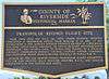
California Historical Landmarks in Riverside County, California
List table of the properties and districts listed on the California Historical Landmarks within Riverside County, southern California.
- Note: Click the "Map of all coordinates" link to the right to view a Google map of all properties and districts with latitude and longitude coordinates in the table below.
Listings
| Image | [1] | Landmark name | Location | City or town | Summary |
|---|---|---|---|---|---|
| 948 | Blythe Intake | Palo Verde Dam 33°43′54″N 114°30′57″W / 33.731783°N 114.5158°W |
Blythe | ||
.jpg) |
101 | Giant desert figures | On Hwy 95 33°48′00″N 114°31′39″W / 33.799983°N 114.527567°W |
Blythe | |
| 102 | Site of Louis Rubidoux House | 5575 block, Mission Blvd. 33°59′49″N 117°24′22″W / 33.996818°N 117.406047°W |
Rubidoux | ||
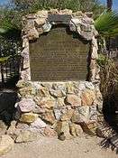
| 188 | Butterfield stage station | 20730 Temescal Canyon Rd. |
Temescal Valley | The marker for the Temescal Butterfield Stage Station has since been removed, replaced during construction of a housing development or when Temescal Canyon Road was widened. The site now appears to be near where Breezy Meadow Lane intersects Temescal Canyon Road.[2][3] | |
| 187 | Carved Rock | 33°46′27″N 117°28′30″W / 33.774225°N 117.47509°W |
Temescal Valley | The petroglyphs, were carved by the Luiseño Indians, their meaning is said to be: 'A chief died here. These are his plumes, his portrait, his sign, and the animals sacred to him.' The Luiseño Indians who lived in Temescal Valley belonged to the Shoshoean linguistic group. The rock has been damaged by vandals. It is located on the east side of Temescal canyon, 8 miles (13 km) south of Corona.[4] | |
| 992 | Contractor's General Hospital | Next to post office, Ragsdale Rd. 33°42′49″N 115°24′09″W / 33.713533°N 115.402633°W |
Desert Center | ||
| 738 | Corona Founders Monument | Corona City Park 33°52′29″N 117°33′20″W / 33.874647°N 117.555653°W |
Corona | ||
| 787 | de Anza crossing of the Santa Ana River, 1775 and 1776 | Jurupa Hills Country Club Golf Course 33°58′33″N 117°26′28″W / 33.975917°N 117.441233°W |
Riverside | ||
| 985 | Desert Training Center | 18 miles north of I-10 on SR 177 33°54′30″N 115°14′53″W / 33.908333°N 115.248033°W |
California-Arizona Maneuver Area – Camp Coxcomb | ||
| 985 | Desert Training Center | on SR 62, 5.4 miles east of SR 177 34°04′50″N 115°07′59″W / 34.080467°N 115.133133°W |
California-Arizona Maneuver Area – Camp Granite | ||
 |
985 | Desert Training Center | General George S. Patton Memorial Museum 33°39′42″N 115°43′20″W / 33.661667°N 115.722222°W |
Chiriaco Summit | California-Arizona Maneuver Area – Camp Young |
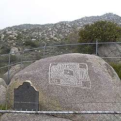 |
557 | Hemet Maze Stone | Maze Stone Park 33°46′52″N 117°03′23″W / 33.781167°N 117.056367°W |
Hemet | |
| 943 | Jensen Alvarado Ranch | 4350 Riverview Dr. 33°59′34″N 117°25′01″W / 33.992778°N 117.416944°W |
Riverside | ||
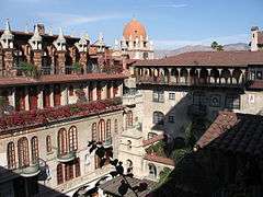 |
761 | Mission Inn | 3649 Mission Inn Ave. 33°59′00″N 117°22′22″W / 33.983222°N 117.37275°W |
Riverside | |
| 638 | Old Temescal Road | Old Hwy 71 33°45′56″N 117°29′12″W / 33.765609°N 117.486699°W |
Temescal Valley | This route was first used by Luiseño and Gabrieleno Indians, whose villages were nearby. Leandro Serrano established a home here in 1820. Jackson and Warner traveled this route in 1831, and Frémont in 1848. It was the Southern Emigrant Trail for gold seekers in 1849 an other immigrants to California from then on. It was the Butterfield Overland Mail route from 1858 to 1861, part of the military road between Los Angeles and Fort Yuma from 1861 to 1866. From 1867 to 1877 it was again part of a stagecoach route between Los Angeles and Yuma, Arizona. With the advent of the automobile it was paved, becoming California State Route 71.[5] | |
| 190 | Painted Rock | From Temescal Canyon Rd, go 0.1 mi E on Dawson Canyon Rd, then go 0.1 mi NE on Gravel Pit Rd, then 0.2 mi S along railroad track berm, site is 50 ft W of berm |
Temescal Valley | In tribute to the earliest record of any people in this region, the Santa Fe Railway preserved this rock with its ancient pictograph, and the Committee of the Corona Women's Improvement Club placed a tablet marking the location 7 miles (11 km) south of Corona.[6] | |
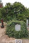 |
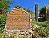
20 | Parent Washington Navel Orange Tree | City Park, SW corner of Magnolia and Arlington Avenues 33°56′46″N 117°24′06″W / 33.94615°N 117.401667°W |
Riverside | |
 |
104 | Pochea Indian village site | Ramona Bowl, 27400 Ramona Bowl Road (S. Girard Street) 33°43′12″N 116°56′58″W / 33.7199°N 116.9494°W |
Hemet | |
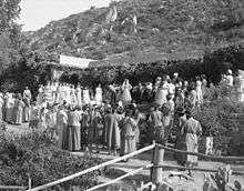 |
1009 | Ramona Bowl | 27400 Ramona Bowl Road (S. Girard Street) 33°43′11″N 116°56′58″W / 33.719633°N 116.949533°W |
Hemet | |
| 1005 | Rancho Santa Rosa | 22115 Tenaja Rd. 33°33′N 117°16′W / 33.55°N 117.27°W |
Murrieta | ||
| 303 | Robidoux Grist Mill Site | 5540 Molina Way 33°59′43″N 117°24′24″W / 33.99525°N 117.406583°W |
Rubidoux | ||
| 749 | Saahapta | Brookside Rest Area, W-bound I-10 |
Beaumont | Chief Juan Antonio and his band of Cahuilla Indians helped Californio settlers in the San Bernardino area defend their property and livestock against outlaws and other tribal raiders during the 1840s and early 1850s. In late 1851, Juan Antonio, his warriors and their families, settled at nearby Saahatpa. During the winter of 1862-63, a smallpox epidemic swept through Southern California killing many Native Americans, including Juan Antonio and many of his people in Saahapta. Cahuilla tradition asserts that the U.S. Government sent Army blankets that were contaminated with smallpox. After this disaster, Saahatpa was abandoned. | |
 |
185 | Serrano Boulder | From I-15, take Old Temescal Canyon Rd S 0.4 mi to Lawson Rd, then go W 0.2 mi to dirt rd, then S 0.1 mi to site 33°46′10″N 117°29′27″W / 33.769333°N 117.4909°W |
Temescal Valley | Boulder marks the site of the first house in Riverside County, erected on the Rancho Temescal by Leandro Serrano about May 1824.[7] |
| 186 | Serrano tanning vats | I-15 & Temescal Valley Rd. 33°45′47″N 117°28′08″W / 33.76305°N 117.468833°W |
Temescal Valley | Two vats used in making leather from cow hides, built in 1819 by the Luiseño Indians under the direction of Leandro Serrano.[8][9] | |
| 103 | Site of the de Anza camp, March 1774 | 60901 Coyote Canyon Rd. 33°29′57″N 116°36′13″W / 33.499105°N 116.603694°W |
Riverside | ||
| 224 | Site of the Third Serrano Adobe | NE corner of I-15 and Old Temescal Road 33°46′40″N 117°29′10″W / 33.7779°N 117.486°W |
Temescal Valley | Leandro Serrano set out orchards and vineyards and cultivated some of the fertile lands of the Temescal Valley. In the 1840s he built his third adobe on the Rancho Temescal, which the Serrano family occupied until 1898.[10] | |
 |
989 | Soviet 1937 transpolar flight landing site | Cottonwood and Sanderson Streets 33°46′56″N 116°57′33″W / 33.782183°N 116.95925°W |
San Jacinto |
See also
| Wikimedia Commons has media related to California Historical Landmarks in Riverside County, California. |
- List of California Historical Landmarks
- National Register of Historic Places listings in Riverside County, California
References
- ↑ http://ohp.parks.ca.gov/?page_id=21387
- ↑ Butterfield Stage Station Historical Marker, California; USGS 1:24K topographic map Corona South, CA., topoquest.com
- ↑ Butterfield Stage Station(California Historical Landmark No. 188)
- ↑ Carved Rock (California Historical Landmark #187)
- ↑ Old Temescal Road (California Historical Landmark #638)
- ↑ Painted Rock (California Historical Landmark #190)
- ↑ Serrano Boulder (California Historical Landmark No. 185)
- ↑ Serrano Tanning Vats (California Historical Landmark No. 186)
- ↑ Leandro Serrano's Tanning Vats
- ↑ Ruins of Third Serrano Adobe (California Historical Landmark No. 224)
External links
- NoeHill Travels in California: Historic Sites in Riverside County for a listing of NRHP and California landmarks
This article is issued from Wikipedia - version of the 10/25/2015. The text is available under the Creative Commons Attribution/Share Alike but additional terms may apply for the media files.