Calderdale Way
| Calderdale Way | |
|---|---|
|
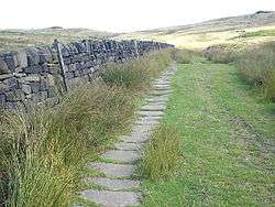
Calderdale Way near Mankinholes | |
| Established | 1978[1] |
| Length | 50 miles (80 km) |
| Location | Calderdale, West Yorkshire |
| Trailheads |
West Vale near Elland (circular) |
| Use | Hiking, Fell-running |
| Elevation | |
| Elevation gain/loss | 2,595 metres (8,514 ft)[1] |
| Highest point | 379 metres (1,243 ft)[1] |
| Hiking details | |
| Trail difficulty | challenging[1] |
The Calderdale Way is a 50-mile (80 km) long-distance footpath in West Yorkshire, England.[2] It was devised in the 1970s to draw attention to attractions in the Calderdale district which was being established at that time.[3]:6
The route is circular and walks can be started at any point. The official start is at Clay House in West Vale and the route includes much exposed moorland, woodland paths, a short section of canal towpath and some road sections. It passes through several settlements, including Ripponden, Mankinholes, Todmorden, Heptonstall, Holdsworth, Shelf and Brighouse.[3]:10 One published guidebook divides the walk into four day-long sections.[3]:46
- West Vale–Mankinholes (13.5 miles/21.7 km)
- Mankinholes–Heptonstall (11.5 miles/18.5 km)
- Heptonstall–Catherine Slack (11.5 miles/18.5 km)
- Catherine Slack–West Vale (13.5 miles/21.7 km)
The route is the basis for the annual Calderdale Way Relay organised by Halifax Harriers.[4]
The Calderdale Way Ultra now takes in the whole 50 miles organised by Cannonball Events.[5]
References
- 1 2 3 4 "Calderdale Way". Long Distance Walkers Association. Retrieved 27 August 2013.
- ↑ Crew Heart Support Group: A detailed route description, Retrieved 24 April 2014
- 1 2 3 Hannon, Paul (2009) [2001]. Calderdale Way (2nd ed.). Keighley: Hillside Publications. ISBN 978-1-870141-71-0.
- ↑ "Calderdale Way Relay". Halifax Harriers Running Club. 19 May 2013. Retrieved 27 August 2013.
- ↑ "Calderdale Way Ultra". Cannonball Events. 1 June 2015. Retrieved 3 June 2015.
External links
![]() Media related to Calderdale Way at Wikimedia Commons
Media related to Calderdale Way at Wikimedia Commons