Cajatambo Province
| Cajatambo | |
|---|---|
| Province | |
|
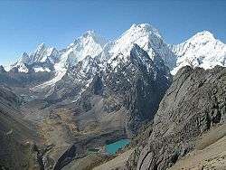
Peaks of the Waywash mountain range on the eastern border of the province as seen from the south | |
 Location of Cajatambo in the Lima Region | |
| Country | Peru |
| Region | Lima |
| Capital | Cajatambo |
| Government | |
| • Mayor | Miguel Angel Carlos Castillo |
| Area | |
| • Total | 1,515.21 km2 (585.03 sq mi) |
| Elevation | 3,376 m (11,076 ft) |
| Population | |
| • Total | 9,618 |
| • Density | 6.3/km2 (16/sq mi) |
| UBIGEO | 1503 |
The Cajatambo Province is one of nine provinces in the Lima Region of Peru. It is bordered to the north by the Ancash Region, to the east by the Huánuco Region, to the south by the Oyón Province, and to the west by the Huaura Province.
Overview
From 1851 to 1916 Cajatambo was part of Ancash Region and also included the areas of Bolognesi Province and Ocros Province, which remained in that region. Bolognesi, including Ocros until 1990, split from Cajatambo in 1903; in 1916 Cajatambo was given to Lima Region.
Geography
The Waywash mountain range traverses the province. Some of the highest mountains of the province are listed below:[1]
- Awkillu
- Awkin
- Ayar Mach'ay
- Challwaqucha
- Chhanka
- Ch'ura
- Ichik Qayqu
- Mataqucha
- Millpu
- Mishi Waqanan
- Mit'u Punta
- Muntiqucha
- Parya Ukru
- Pishtaq
- Puka Parya
- Puka Qaqa
- Puka Qaqa (Mun.)
- Pumarinri
- Punta Rukma
- Puskan T'urpu
- Puywan
- Phasa Pukyu
- Phuyuq
- P'ukru
- Qullqan
- Qulluta Warkhu
- Qupan
- Q'ara Chuku
- Q'aramarka
- Rahu Qulluta
- Rasaq
- Rukma
- Sarapu
- Suyruqucha
- Shawaq
- T'uruqucha
- Utkhush
- Wakrish
- Wanchaq
- Waqra
- Waqra Punta
- Waqshash
- Wathiyaqucha
- Waylla Hirka
- Waylla Hirka (Caj.)
- Yana Kushman
- Yana Hirka
- Yana K'uchu
- Yana Paryan
- Yana Uqsha
- Yura Hirka
- Yuraq Qaqa
Administrative divisions
The province is divided into five districts:
Population
The province has a population of approximately 10,000 people.
Capital
The capital of the province is the city of Cajatambo.
Industry
The principal products of the province are cattle and sheep, although cochineal is also produced in the area.
See also
References
- ↑ escale.minedu.gob.pe UGEL map of the Cajatambo Province (Lima Region)
External links
- (Spanish) www.cajatambo.com
![]() This article incorporates text from a publication now in the public domain: Chisholm, Hugh, ed. (1911). "Cajatambo". Encyclopædia Britannica (11th ed.). Cambridge University Press.
This article incorporates text from a publication now in the public domain: Chisholm, Hugh, ed. (1911). "Cajatambo". Encyclopædia Britannica (11th ed.). Cambridge University Press.
Coordinates: 10°20′08″S 76°50′03″W / 10.33556°S 76.83417°W