Cadillac, Michigan
| City of Cadillac | |
|---|---|
| City | |
 | |
| Nickname(s): Tree City USA, City on the Lakes | |
 Location of Cadillac within Wexford County, Michigan | |
| Coordinates: 44°15′N 85°24′W / 44.250°N 85.400°W | |
| Country | United States |
| State | Michigan |
| County | Wexford |
| Government | |
| • Type | Council-Manager |
| • Mayor | Carla Filkins |
| • City Administrator | Marcus Peccia |
| Area[1] | |
| • Total | 9.02 sq mi (23.36 km2) |
| • Land | 7.16 sq mi (18.54 km2) |
| • Water | 1.86 sq mi (4.82 km2) |
| Elevation | 1,309 ft (399 m) |
| Population (2010)[2] | |
| • Total | 10,355 |
| • Estimate (2012[3]) | 10,270 |
| • Density | 1,446.2/sq mi (558.4/km2) |
| Time zone | EST (UTC-5) |
| • Summer (DST) | EDT (UTC-4) |
| ZIP code | 49601 |
| Area code(s) | 231 |
| FIPS code | 26-12320[4] |
| GNIS feature ID | 1619393[5] |
| Website | http://www.cadillac-mi.net |
Cadillac /ˈkædᵻlæk/ is a city in the U.S. state of Michigan and is the county seat of Wexford County.[6][7] The population was 10,355 at the 2010 census. The city is situated at the junction of US 131, M-55 and M-115. The geographic center of Michigan is approximately five miles (8.05 km) north-northwest of Cadillac.[8]
Cadillac became the county seat after the so-called "Battle of Manton," in which a show of force was involved in enforcing a controversial decision to move the county seat from Manton.
History
Village of Clam Lake
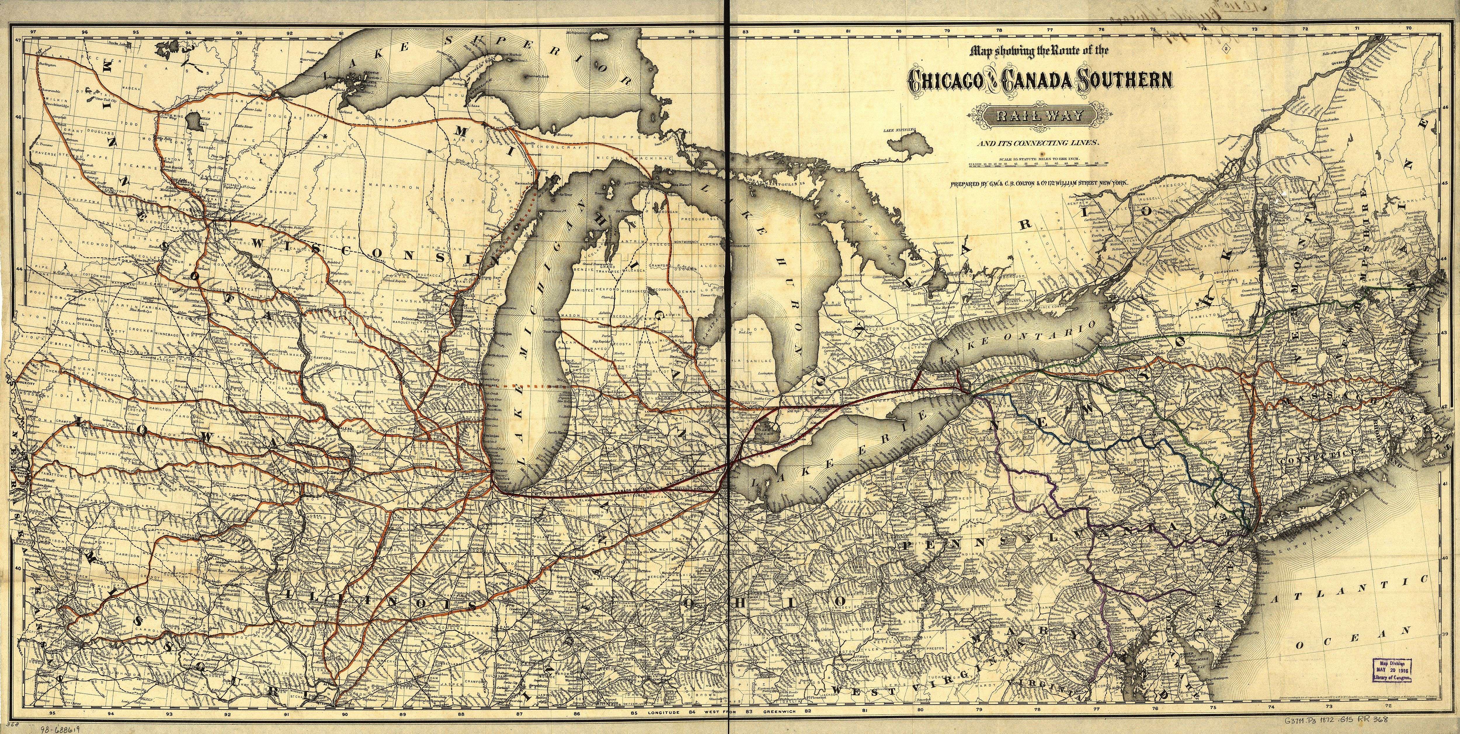
In this 1872 map, Clam Lake is shown as the sole stop in Wexford County and as the northern-most stop on the Grand Rapids and Indiana rail line.
Although European explorers and traders visited the area since the 18th century, permanent white communities were not established until some time later. Initial settlements were connected with the logging industry.
In 1871, Cadillac's first sawmill began operations. Originally called the Pioneer Mill, it was built by John R. Yale. That same year, George A. Mitchell, a prominent Cadillac banker and railroad entrepreneur, and Adam Gallinger, a local carpenter, formed the Clam Lake Canal Improvement and Construction Company. Two years later, the Clam Lake Canal was constructed between Big and Little Clam lakes, present-day Lakes Mitchell and Cadillac. Sawmill owners used the canal to transport timber from Big Clam Lake to the mills and railroad sites—the G.R. & I. Railroad had reached the area in 1872—on Little Clam Lake, in Cadillac.[9]
Cadillac was originally named Clam Lake and was incorporated as a village in 1874. George Mitchell was elected the first mayor.[9] The village was incorporated as a city in 1877 and renamed Cadillac, after Antoine Laumet de La Mothe, sieur de Cadillac, a Frenchman who made the first permanent settlement at Detroit in 1701.[10]
Battle of Manton
The Wexford County seat of government, originally located in Sherman, was moved to Manton in 1881, as the result of a compromise between the feuding residents of Cadillac and Sherman. Cadillac partisans, however, won the county seat by county-wide vote in April 1882.[9] The day following the election a sheriff's posse left the city for Manton by special train to seize the county records. After arriving and collecting a portion of the materials, however, an angry crowd confronted the Cadillac men and drove them from the town.[11]
When the sheriff returned to Cadillac, a force consisting of several hundred armed men was assembled; this group reportedly included a brass band. The Sheriff's force, some of whom may have been intoxicated, traveled back to Manton to seize the remaining records. Although Manton residents confronted the Cadillac men and barricaded the courthouse, the posse successfully seized the documents and, in dubious glory, returned to Cadillac.[11]
City of Cadillac
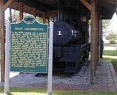
In 1878, Ephraim Shay perfected his Shay locomotive, which was particularly effective in its ability to climb steep grades, maneuver sharp turns and manage imperfections in railroad tracks. Cadillac was home to the Michigan Iron Works Company, which manufactured the Shay locomotive for a short time in the early 1880s.[12] It was however the lumber industry that continued to dominate the city, drawing in a large immigrant labor force, most of whom were Swedish (two of Cadillac's sister cities are Mölnlycke, Sweden, and Rovaniemi, Finland).

In 1899, the Cadillac Club formed, the forerunner of the Cadillac Area Chamber of Commerce.[13] Gradually, various manufacturing firms found success in Cadillac. By the early 20th century, with the lumber depleted, the timber industry was in decline. Industrial development soon dominated the local economy, and it continues to do so today. Cadillac's range of industries includes the manufacture of pleasure boats, automotive parts, water-well components, vacuum cleaners, and rubber products.[14]
In 1936, the U.S. Forest Service and the Civilian Conservation Corps created the Caberfae Ski Area, which led to promotion of the area as a tourist center.[15] Caberfae remains in operation today, as the oldest ski resort in the midwest.[16] Tourism has since become an important sector of Cadillac's economy.[17][18] In the summer, tourists travel to the city for boating, fishing, hiking, mountain biking and camping. During the fall, hunting and color tours are popular.[19] The winter is possibly the busiest season; the area can be found packed with downhill skiers, cross-country skiers, ice-fishers, snow-shoers and–most of all-snowmobilers.[20] The North American Snowmobile Festival (NASF) is held on frozen Lake Cadillac every winter.[21]
Thirsty's, a gas station on M-55 west of Cadillac, was the home of Samantha or "Sam The Bear" from the 1970s through the late 1990s, when Sam died of old age. Sam was the only brown bear in captivity in the US at the time to hibernate naturally. Sam lived in a large cage in front of the gas station and was fed ice cream cones by tourists every summer.
In October 1975 the rock group Kiss visited Cadillac and performed at the Cadillac High School gymnasium. They played the concert to honor the Cadillac High School football team. In previous years, the team had compiled a record of sixteen consecutive victories, but the 1974 squad opened the season with two losses. The assistant coach, Jim Neff, an English teacher and rock'n'roll fan, thought to inspire the team by playing Kiss music in the locker room. He also connected the team's game plan, K-I-S-S or "Keep It Simple Stupid", with the band. The team went on to win seven straight games and their conference co-championship. After learning of their association with the team's success, the band decided to visit the school and play for the homecoming game.[22][23]
Historic landmarks
Cadillac maintains a number of state historic landmarks. Most are marked with a green "Michigan Historical Marker" sign that includes a description of the landmark. There are six markers within the city limits: 'Cadillac Carnegie Library,' 'Charles T. Mitchell House,' 'Clam Lake Canal,' 'Cobbs & Mitchell Building,' 'Cobbs & Mitchell No. 1' and the 'Shay Locomotive,' which is pictured at the right. Two more are in the near Cadillac area ('Caberfae Ski Resort' and 'Greenwood Disciples of Christ Church') and another two are dispersed in surrounding Wexford County ('Battle of Manton' and '1st Wexford County Court House').[24]
Geography
Topography
According to the United States Census Bureau, the city has a total area of 9.02 square miles (23.36 km2), of which 7.16 square miles (18.54 km2) is land and 1.86 square miles (4.82 km2) is water.[1]
The 1,150-acre (5 km2) Lake Cadillac is entirely within the city limits, and some claim it is the largest lake entirely in any city in the United States. The larger, 2,580-acre (10 km2) Lake Mitchell is nearby on the west side of the city, with 1,760 feet (540 m) of shoreline within the city's municipal boundary. The lakes were connected by a stream which was replaced in 1873 by the Clam Lake Canal. The canal was featured on Ripley's Believe It or Not in the 1970s due to the phenomenon that in winter the canal freezes before the lakes and then after the lakes freeze, the canal thaws and remains unfrozen for the rest of the winter.[25]
Cadillac sits on the eastern edge of the Manistee National Forest and the surrounding area is heavily wooded with mixed hardwood and conifer forests. A main agricultural industry in the area is Christmas tree farming. Cadillac was chosen in 1988 to donate the holiday tree to sit on the lawn of the U.S. Capitol building in Washington D.C.[16]
The area surrounding Cadillac is primarily rural, and is considered to be part of Northern Michigan. The small size of nearby communities make the city a major commercial and industrial hub of the region.[26]
 |
Mesick, Michigan | Manton, Michigan | Lake City, Michigan | |
| Wellston, Michigan | |
McBain, Michigan | ||
| ||||
| | ||||
| Tustin, Michigan | Marion, Michigan |
Cityscape
The commercial center of the city is located on the eastern edge of Lake Cadillac. Most downtown buildings range from two to five stories in height and face the traditional corridor of travel through town, Mitchell Street, the city's tree-lined main street. The downtown contains a movie theater, gift shops, restaurants, a bookstore, specialty food stores, jewelers, clothing retailers and various other businesses.[27][28] The Courthouse Hill Historic District, established in April 2005, lies adjacent to the city's commercial center. The District contains a number of large Victorian-style residences built by the lumber barons and businessmen who helped establish the city in the 1870s.[29] Population and building density is highest in this area.[30]
On the western portion of Lake Cadillac, where M-55 intersects M-115, is what is locally referred to as Cadillac West. This is a small commercial district, bordering Mitchell State Park and the two lakes, which caters mostly to tourists. It contains a number of motels and restaurants.[31]
Along the northern and southern stretches of the lake are the residential areas of the city. They are generally of low to moderate density, characterized primarily by single family structures.[32]
Climate
Cadillac experiences a typical northern Michigan climate, undergoing temperate seasonal changes, influenced by the presence of Lake Michigan and the inevitable lake effect. Winters are generally cold with large amounts of snowfall. Summers are warm.[33] The average high temperature in July is 80 °F (27 °C) and the average low is in February, at 9 °F (−13 °C). Summer temperatures can exceed 90 °F (32 °C), and winter temperatures can drop below 0 °F (−18 °C). Average annual rainfall is 30 inches (76 cm), and average annual snowfall is 81 inches (206 cm) . Snowfall typically occurs between the months of November and March. According to the Köppen Climate Classification system, Cadillac has a humid continental climate, abbreviated "Dfb" on climate maps.[34]
| Climate data for Cadillac Michigan | |||||||||||||
|---|---|---|---|---|---|---|---|---|---|---|---|---|---|
| Month | Jan | Feb | Mar | Apr | May | Jun | Jul | Aug | Sep | Oct | Nov | Dec | Year |
| Average high °F (°C) | 26 (−3) |
27 (−3) |
36 (2) |
52 (11) |
65 (18) |
75 (24) |
80 (27) |
78 (26) |
69 (21) |
57 (14) |
41 (5) |
30 (−1) |
53 (11.8) |
| Average low °F (°C) | 11 (−12) |
9 (−13) |
18 (−8) |
30 (−1) |
41 (5) |
52 (11) |
56 (13) |
54 (12) |
48 (9) |
38 (3) |
27 (−3) |
17 (−8) |
33.4 (0.7) |
| Average precipitation inches (mm) | 1.7 (43) |
1.6 (41) |
1.9 (48) |
2.7 (69) |
3.0 (76) |
3.1 (79) |
2.9 (74) |
2.9 (74) |
3.5 (89) |
2.8 (71) |
2.7 (69) |
1.7 (43) |
30.4 (772) |
| Source: Weatherbase[35] | |||||||||||||
Superfund sites
Cadillac is also home to two superfund sites according to the U.S. Environmental Protection Agency. One located at 1100 Wright Street,[36] the former home of Kysor Industrial Corp. The other is located at 1002 6th Street,[37] the former home of Northernaire Plating.
Demographics
| Historical population | |||
|---|---|---|---|
| Census | Pop. | %± | |
| 1880 | 2,213 | — | |
| 1890 | 4,461 | 101.6% | |
| 1900 | 5,997 | 34.4% | |
| 1910 | 8,375 | 39.7% | |
| 1920 | 9,750 | 16.4% | |
| 1930 | 9,570 | −1.8% | |
| 1940 | 9,855 | 3.0% | |
| 1950 | 10,425 | 5.8% | |
| 1960 | 10,112 | −3.0% | |
| 1970 | 9,990 | −1.2% | |
| 1980 | 10,199 | 2.1% | |
| 1990 | 10,104 | −0.9% | |
| 2000 | 10,000 | −1.0% | |
| 2010 | 10,355 | 3.6% | |
| Est. 2015 | 10,373 | [38] | 0.2% |
2010 census
As of the census[2] of 2010, there were 10,355 people, 4,280 households, and 2,625 families residing in the city. The population density was 1,446.2 inhabitants per square mile (558.4/km2). There were 4,927 housing units at an average density of 688.1 per square mile (265.7/km2). The racial makeup of the city was 95.6% White, 0.5% African American, 0.6% Native American, 1.0% Asian, 0.4% from other races, and 1.8% from two or more races. Hispanic or Latino of any race were 1.8% of the population.
There were 4,280 households of which 32.9% had children under the age of 18 living with them, 39.2% were married couples living together, 16.4% had a female householder with no husband present, 5.7% had a male householder with no wife present, and 38.7% were non-families. 32.0% of all households were made up of individuals and 14% had someone living alone who was 65 years of age or older. The average household size was 2.34 and the average family size was 2.90.
The median age in the city was 36.5 years. 24.7% of residents were under the age of 18; 10% were between the ages of 18 and 24; 24.4% were from 25 to 44; 23.8% were from 45 to 64; and 17.1% were 65 years of age or older. The gender makeup of the city was 47.4% male and 52.6% female.
2000 census
As of the census[4] of 2000, there were 10,000 people, 4,118 households, and 2,577 families residing in the city. The population density was 1,466.0 per square mile (566.1/km²). There were 4,466 housing units at an average density of 654.7 per square mile (252.8/km²). The racial makeup of the city was 96.55% White, 0.21% Black or African American, 0.92% Native American, 0.63% Asian, 0.03% Pacific Islander, 0.28% from other races, and 1.38% from two or more races. 1.18% of the population were Hispanic or Latino of any race.
There were 4,118 households out of which 32.2% had children under the age of 18 living with them, 43.9% were married couples living together, 14.2% had a female householder with no husband present, and 37.4% were non-families. 31.8% of all households were made up of individuals and 14.4% had someone living alone who was 65 years of age or older. The average household size was 2.37 and the average family size was 2.96.
In the city the population was spread out with 26.2% under the age of 18, 9.6% from 18 to 24, 27.9% from 25 to 44, 19.6% from 45 to 64, and 16.7% who were 65 years of age or older. The median age was 36 years. For every 100 females there were 91.4 males. For every 100 females age 18 and over, there were 84.4 males.
The median income for a household in the city was $29,899, and the median income for a family was $36,825. Males had a median income of $29,773 versus $21,283 for females. The per capita income for the city was $16,801. About 10.9% of families and 13.7% of the population were below the poverty line, including 15.4% of those under age 18 and 13.3% of those age 65 or over.
Government
Cadillac was incorporated as a city in 1877. It is a home rule city with a Council-Manager form of government-one.[40]
Current Council members are Shari Spoelman, Antoinette Schippers, Arthur Stevens, James Dean and Carla Filkins(Mayor).[41] The present City Manager is Marcus Peccia.[42]
Cadillac is located in Michigan's 2nd congressional district, represented by Republican Bill Huizenga.[43]
Economy
Manufacturing has been the greatest employer in Cadillac since the logging industry. Presently, over 26% of the city's labor force is employed in manufacturing.[44] There are three industrial parks within the city limits, comprising 7% of the total land use in Cadillac and 47% of the city's tax base.[45] Much of the city's economic performance is determined by the fortunes of local industry.
Major manufacturers include Four Winns, AAR Manufacturing, Avon Rubber, FIAMM Technologies, Michigan Rubber Products and Rexair.

Apart from its manufacturing base, Cadillac is frequently considered by those who know it to be a tourist town. The center of the city is generally perceived to have a "small-town-feel."[46] In the summer, the downtown fills with tourists, many of whom are from southern Michigan. The city center is in fact only one block from Lake Cadillac and, by docking at the public docks, is as nearly accessible by boat as it is by car. The city's immediate proximity to two lakes, as well as Manistee National Forest, Pere Marquette State Forest, Mitchell State Park and a number of major highways ensures that tourism occupies a significant sector of the local economy.[16]
During the winter months Lake Cadillac and Lake Mitchell freeze over and the city becomes covered with snow. Cadillac is connected to a number of trail systems heavily used by winter recreation enthusiasts, and the city itself integrates unusually well into the corridors of travel created by snowmobilers.[47]
Cadillac is also known as Chestnut Town, USA. The local area is home to a relatively large number of American chestnut trees, planted by pioneers from New York and Pennsylvania who settled in western Michigan. A blight in the early 20th century wiped out nearly every American Chestnut tree, but those in western Michigan developed a mysterious resistance and survived.
Lou Gehrig's Disease
Based on a single, limited study involving twenty people, some people have labeled Cadillac as one of three "hot spots" for Lou Gehrig's Disease in the US. However, the study made no attempt to ascertain the occurrence of the disease in other parts of the state, or elsewhere in the country. The study was designed to examine the possible occurrence of the disease due to genetic influences. The occurrence of the disease within the city limits of Cadillac is reportedly over 100 times the normal rate. The cause of the abnormally large occurrence of the disease in Cadillac remains unknown.[48]
Education
Cadillac's public education system has a total of 10 schools, with approximately 3,100 students and 166 teachers with a student:teacher ratio of 19.1:1. Cadillac has 4 private primary and secondary schools with approximately 394 students, 20 teachers and a student:teacher ratio of 20:1.[49]
Cadillac Area Public Schools (CAPS)
The city has two high schools, Cadillac High School, and Cooley Alternative. The area also has a junior high school, covering grades 7 and 8, located adjacent to the high school, and a middle school, Mackinaw Trail Middle School, covering grades 5 and 6. There are four elementary schools, Forest View Elementary, Franklin Elementary, Kenwood Elementary, and Lincoln Elementary.[50]
Cadillac also has an alternative high school, located in the building that formerly housed Cooley Elementary School. Adult high school and GED courses are offered there as well. As a whole, the programs at Cooley are part of a curriculum that aids individuals in overcoming the exceptional obstacles to their educational and workforce goals.
Vocational career training is available to high school students free of charge in Cadillac and nearby schools at Wexford-Missaukee Independent School District (ISD) Career Tech Center (formerly Wexford-Missaukee Vocational Center or Voc-Tech). Students are bussed for part of the day to the Career Tech Center from their respective schools and receive credits toward high school graduation. Students are also able to earn certification in a chosen trade. Courses include:
- Agriscience
- Allied Heath Technologies
- Automotive
- Building Trades
- Business Management and Administration
- Computers and Electronics
- Digital Media Productions
- Electrical Occupations (formally Robotics and Automation)
- Heavy Equipment
- Hospitality Retailing and Entrepreneureship
- Machine Trades
- Metal Fabrication
- Power sports and Equipment
Cosmetology is offered through the Career Tech Center, but at an off-campus location in downtown Cadillac. Adults can attend the vocational or cosmetology school with tuition or financial aid for certification.[51]
Cadillac hosts the Wexford-Missaukee ISD Special Education for residents of the two counties who are in need of special services. This school is on the same campus as the Career Tech Center.
The class of 2006 was the largest class to go through Cadillac Public Schools.
Private schools
Cadillac offers several options for private religious education.[52]
Cadillac Heritage Christian offers nondenominational Christian education from pre-K through 12th grade. It is a coed school with 98 students and a teacher:student ratio of 1:11. Graduating classes are typically between 3–12 students.
Northview SDA Christian School has 5 students in grades 1–9. It is a coed Seventh Day Adventist school.
Noah's Ark Day School is a small alternative non-denominational Christian school for students in pre-K through first grade only. It is coed with 42 students and 1 teacher.
Cadillac's largest and most well-known private school is St. Ann School, a coed private Roman Catholic school with 236 students in grades pre-K through 7. The teacher:student ratio is 1:26. St. Ann is a member of the National Catholic Education Association. No Catholic high school education is offered at St. Ann School, and students typically attend public school for grades 8–12.
Training schools
Northwoods Aviation, located at Wexford County Airport, offers training programs for piloting and servicing aircraft. Northwoods Aviation also offers primary instruction for those interested in sport pilot, private, and commercial certificates.[53]
The Cadillac Institute of Cosmetology (formerly Cadillac Academy of Beauty) is a full service teaching salon in downtown Cadillac that offers training for general cosmetologists and specialized technicians to high school students through a partnership with Wexford-Missaukee Intermediate School District. Training is also available to adult students though private courses on a tuition basis. Upon completion of the program, students are qualified to take the state board exam to become a licensed cosmetologist or specialty technician.
Colleges
The Baker College-Cadillac campus occupies 66 acres (270,000 m2) just outside the City of Cadillac. The school has an enrollment of more than 1,300 students and offers Associate's and bachelor's degrees, in addition to professional certifications.[54]
Transportation
Major highways
Cadillac is situated as the confluence of three highways: US 131, M-55 and M-115. Prior to 2001, the northern end of the freeway portion of US 131 was located at the southern entrance to Cadillac. With the construction of a bypass, the US 131 freeway was extended around the east side of the city. The former route of the highway through downtown Cadillac was redesignated as BUS US 131. In the city, BUS US 131 is named Mitchell Street, after George Mitchell, but may be referred to as main street.
 US 131 bypasses the city to the east. The freeway continues southerly toward Big Rapids and Grand Rapids and northerly toward Manton before transitioning to a two-lane highway for the remainder of the distance to Petoskey.
 Bus. US 131, a loop route through downtown, running largely along the former route of US 131 through the city.
 M-55 is a major two-lane east-west route across the state, connecting with Manistee on the west and Houghton Lake and Tawas City on the east.
 M-115, another major two-lane route, runs diagonally from Clare to the southeast to Frankfort to the northwest.
Rail
The city is serviced by rail via the Great Lakes Central Railroad. This is primarily a freight line, although passenger service is expected in the future.[55]
Public transit
- Cadillac and Wexford County jointly operate a local public bus service. The Cadillac/Wexford Transit Authority (CWTA) is a demand-response, public transportation system, and has been in operation since 1974.[56]
- Indian Trails provides daily intercity bus service between Grand Rapids, Michigan and Petoskey, Michigan.[57]
Non-motorized transportation
The White Pine Trail's northern terminus is in Cadillac. The trail, which stretches 92 miles (148 km) and originates from Comstock Park, follows an abandoned railroad bed into the center of the city. The trail is paved from the village of Leroy 16 miles north to Cadillac.[58]
Local media
Newspapers
- The Cadillac News[59]
Radio
- WTCM (580 am, Traverse City) – news and talk
- WLDR (1210 am, Kingsley-Traverse City) – classic country
- WATT (1240 am) – news and talk
- WLJW (1370 am) – religious
- WIAA (88.7 FM, Interlochen) – classical music "IPR Music Radio"
- WOLW (91.1 FM) – religious "Northern Christian Radio"
- WGCP (91.9 FM) – religious "3ABN Radio"
- WJZQ (92.9 FM) – Top 40 "Z-93"
- WKAD (93.7 FM) – "The Ticket" (Fox Sports Radio)
- WLXV (96.7 FM) – hot AC "Mix 96"
- WUPS (98.5 FM, Houghton Lake) – classic hits
- WLDR (101.9 FM, Traverse City) – country music "101.9 Sunny Country"
- WTCM (103.5 FM, Traverse City) – country music
- WAIR (104.9 FM) – contemporary Christian "Smile-FM"
- WCKC (107.1 FM) – classic rock "The Bear"
- WCDY (107.9 FM, McBain) – hot AC "107.9 CDY"
Television
- WPBN (Channel 7, Traverse City) – NBC
- WWTV (Channel 9) – CBS
- WMNN (Channel 26) – Independent
- WCMV (Channel 27) – PBS
- WGTU (Channel 29, Traverse City) – ABC
- WFQX (Channel 32) – Fox
Notable people
- Jim Bowman, NFL player
- Larry Joe Campbell, actor (According to Jim); born in Cadillac
- Reed Cowan, journalist
- Robert Dorigo Jones, writer
- Jackie Swanson, actress
- Guy Vander Jagt, U.S. congressman from Michigan's 9th congressional district; born in Cadillac
- Luke Winslow-King, musician; born in Cadillac
References
- 1 2 "US Gazetteer files 2010". United States Census Bureau. Archived from the original on July 14, 2012. Retrieved November 25, 2012.
- 1 2 "American FactFinder". United States Census Bureau. Retrieved November 25, 2012.
- ↑ "Population Estimates". United States Census Bureau. Archived from the original on June 17, 2013. Retrieved June 3, 2013.
- 1 2 "American FactFinder". United States Census Bureau. Archived from the original on September 11, 2013. Retrieved 2008-01-31.
- ↑ "US Board on Geographic Names". United States Geological Survey. 2007-10-25. Retrieved 2008-01-31.
- ↑ "Bibliography on Wexford County". Clarke Historical Library, Central Michigan University. Retrieved January 23, 2013.
- ↑ "Find a County". National Association of Counties. Archived from the original on May 31, 2011. Retrieved 2011-06-07.
- ↑ Michigan Geography from NETSTATE. NETSTATE. Retrieved on January 5, 2008.
- 1 2 3 Schindler, Kurt H. (2002) Wexford County Factbook, History, Archived February 4, 2012, at the Wayback Machine. Chapter B2. MSU Extension. Retrieved on January 5, 2008 Archived February 4, 2012, at the Wayback Machine.
- ↑ City of Cadillac, History Archived May 9, 2008, at the Wayback Machine.. City of CadillacRetrieved on January 5, 2008 Archived May 9, 2008, at the Wayback Machine.
- 1 2 Battling for the County Seat. Absolute Michigan. Retrieved on January 5, 2008.
- ↑ Henderson, Rick (2001). Ephraim Shay, the Man. Shaylocomotives.com Retrieved January 5, 2008.
- ↑ Cadillac: Where We Came From Cadillac Area Chamber of Commerce. Retrieved on January 5, 2008
- ↑ Cadillac Industrial Fund Cadillac Area Chamber of Commerce. Retrieved on January 4, 2008
- ↑ Caberfae Ski Club History Caberfae Ski Club Retrieved January 4, 2008 Archived April 11, 2008, at the Wayback Machine.
- 1 2 3 Cadillac Area Visitors Bureau, Cadillac Yesterday Archived December 5, 2007, at the Wayback Machine.. Cadillac Area Visitors Bureau. Retrieved on January 4, 2008.
- ↑ Welcome to Cadillac Archived January 20, 2009, at the Wayback Machine. Michigan History Magazine Retrieved on January 4, 2008 Archived January 20, 2009, at the Wayback Machine.
- ↑ Ingraham, Lesa (July 1, 2002). Summer Tourism Outlook Favorable Cadillac News Retrieved on January 5, 2008
- ↑ Cadillac Fall Color Tours. Michigan.org Retrieved on January 5, 2005.
- ↑ Cadillac, Michigan – Snowmobiling Information Archived October 5, 2011, at the Wayback Machine. Snowtracks.comRetrieved January 5, 2008 Archived October 5, 2011, at the Wayback Machine.
- ↑ Cadillac Area Visitors Bureau NASF Archived September 29, 2011, at the Wayback Machine.. Cadillac Area Visitors Bureau,. Retrieved on January 4, 2008. Archived September 29, 2011, at the Wayback Machine.
- ↑ "KISS was the special guest of Cadillac High School's Homecoming weekend in 1975 - ESPN". ESPN.com.
- ↑ Weinstein, Fannie (1996). The Kiss that Inspired a Small Town Team Archived February 7, 2012, at the Wayback Machine.. Neffzone.com. Retrieved on January 4, 2008. Archived February 7, 2012, at the Wayback Machine.
- ↑ Michigan Historical Markers See "Wexford County." Retrieved on January 5, 2008
- ↑ Cadillac Area Visitors Bureau, FAQ Archived December 5, 2007, at the Wayback Machine.. Cadillac Area Visitors Bureau. Retrieved on January 4, 2008.
- ↑ Schindler, Kurt H. (2002). Wexford County Factbook, Population, Archived February 5, 2012, at the Wayback Machine. Chapter B8. MSU Extension. Retrieved on January 5, 2008 Archived February 5, 2012, at the Wayback Machine.
- ↑ Downtown Cadillac Business Directory Downtown Cadillac Association Retrieved on July 3, 2008
- ↑ Cadillac Area Activities and Attractions Archived July 11, 2008, at the Wayback Machine. Cadillac Area Visitors Bureau Retrieved on January 5, 2008
- ↑ Cadillac's Courthouse Hill Historic District City of Cadillac Retrieved on January 5, 2008
- ↑ b=50|l=en|t=4001|zf=0.0|ms=thm_def|dw=0.1397926221024198|dh=0.07458776315041693|dt=gov.census.aff.domain.map.EnglishMapExtent|if=gif|cx=-85.416605|cy=44.2541885|zl=4|pz=4|bo=|bl=|ft=350:349:335:389:388:332:331|fl=403:381:204:380:369:379:368|g=16000US2612320|ds=DEC_2000_SF1_U|sb=50|tud=false|db=100|mn=0|mx=41250|cc=1|cm=1|cn=5|cb=|um=Persons/Sq%20 Mile|pr=0|th=DEC_2000_SF1_U_M00090|sf=N|sg=&-PANEL_ID=tm_result&-_pageY=&-_lang=en&-geo_id=16000US2612320&-_pageX=&-_mapY=&-_mapX=&-_latitude=&-_pan=&-ds_name=DEC_2000_SF1_U&-_longitude=&-_changeMap=Identify Cadillac city, Michigan by Block Group: Persons per Square Mile Archived July 12, 2014, at the Wayback Machine. U.S. CensusRetrieved on July 3, 2008 Archived July 12, 2014, at the Wayback Machine.
- ↑ For evidence on the usage of the name Cadillac West and the commercial features of the district, look for descriptions in local websites such as Cadillac Area Snowmobile Lodging Guide and Cadillac Area Lodging. Retrieved on January 5, 2008
- ↑ City of Cadillac Zoning Archived May 14, 2008, at the Wayback Machine. Wexford County GIS Archived October 7, 2008, at the Wayback Machine. Retrieved on July 3, 2008
- ↑ Cadillac Weather & Climate (2006). Michigan Vacations (accessed July 20, 2006).
- ↑ "Cadillac, Michigan Köppen Climate Classification (Weatherbase)". Weatherbase.
- ↑ "Weatherbase: Historical Weather for Cadillac Michigan, United States of America". Retrieved November 6, 2008.
- ↑ "Superfund Information Systems Home - US EPA". epa.gov. Archived from the original on February 22, 2012.
- ↑ "Superfund Information Systems Home - US EPA". epa.gov. Archived from the original on February 22, 2012.
- ↑ "Annual Estimates of the Resident Population for Incorporated Places: April 1, 2010 to July 1, 2015". Retrieved July 2, 2016.
- ↑ "Census of Population and Housing". Census.gov. Archived from the original on April 22, 2013. Retrieved June 4, 2015.
- ↑ Cadillac, The Community: Government Archived May 9, 2008, at the Wayback Machine., Retrieved on March 23, 2010
- ↑ "Cadillac, MI - Official Website - City Council". civicplus.com.
- ↑ Administration City of Cadillac Retrieved on March 23, 2010
- ↑ U.S. Congressman Bill Huizenga Official website of Bill Huizenga.
- ↑ 2000 U.S. Census Data Archived December 13, 2011, at the Wayback Machine. U.S. Census Retrieved on January 5, 2008
- ↑ City of Cadillac Industrial Parks Archived May 11, 2008, at the Wayback Machine. City of CadillacRetrieved on January 5, 2008 Archived May 11, 2008, at the Wayback Machine.
- ↑ Whetstone, Matt (December 7, 2007). Survey says: Cadillac good, improvement needed Cadillac News Retrieved on January 5, 2008
- ↑ For details on popular trails, see Cadillac Snowmobiling Retrieved on January 5, 2008
- ↑ Kaminski, Frank (March 14, 2003). Disease Rates in Greenville, Cadillac Puzzle Scientists. Archived June 14, 2010, at the Wayback Machine. Capital News Service. Retrieved on January 5, 2008
- ↑ LocalSchoolDirectory
- ↑ Vikingnet VikingNet
- ↑ PublicSchoolReview Archived July 2, 2014, at the Wayback Machine.
- ↑ privateschoolreview
- ↑ Northwoods Aviation
- ↑ Baker College-Cadillac. Online profile. Retrieved on January 5, 2005 Archived September 3, 2006, at the Wayback Machine.
- ↑ Great Lakes Central Railroad. GLC Retrieved on March 4, 2009
- ↑ Cadillac/Wexford Transportation Authority Michigan Department of Transportation Retrieved on January 5, 2008
- ↑ "GRAND RAPIDS-CADILLAC-TRAVERSE CITY-PETOSKEY" (PDF). Indian Trails. January 15, 2013. Retrieved March 9, 2013.
- ↑ Trail Surface Archived August 15, 2010, at the Wayback Machine. White Pine TrailRetrieved on March 5, 2009 Archived August 15, 2010, at the Wayback Machine.
- ↑ "CadillacNews.com". cadillacnews.com.
Further reading
- "Bibliography on Wexford County". Clarke Historical Library, Central Michigan University. Retrieved January 23, 2013.
External links
| Wikimedia Commons has media related to Cadillac, Michigan. |
| Wikivoyage has a travel guide for Cadillac. |
Municipalities and communities of Wexford County, Michigan, United States | ||
|---|---|---|
| Cities |  | |
| Villages | ||
| Charter township | ||
| General law townships | ||
| CDPs | ||
| Other unincorporated communities | ||
Coordinates: 44°15′N 85°24′W / 44.250°N 85.400°W