Cache River Bridge
| Cache River Bridge | |
|---|---|
 | |
| Crosses | Cache River |
| Characteristics | |
| Design | Parker pony truss |
| Material | Steel |
| Total length | 375 feet 11.5 inches (114.592 m) |
| Width | 24 feet (7.3 m) |
| Longest span | 100 feet (30 m) |
| History | |
| Designer | Vincennes Bridge Company |
| Construction end | 1934 |
| Closed | 1994 |
|
Cache River Bridge | |
  | |
| Nearest city | Walnut Ridge, Arkansas |
| Coordinates | 36°4′9″N 90°49′28″W / 36.06917°N 90.82444°WCoordinates: 36°4′9″N 90°49′28″W / 36.06917°N 90.82444°W |
| Area | less than one acre |
| Built | 1934 |
| Architect | AHTD; Vincennes Bridge Co. |
| Architectural style | Parker pony-truss |
| MPS | Historic Bridges of Arkansas MPS |
| NRHP Reference # | 90000523[1] |
| Added to NRHP | April 9, 1990 |
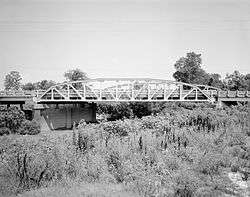
The Cache River Bridge is a Parker pony truss that spans the Cache River between Walnut Ridge and Paragould, Arkansas. It was built in 1934 by the Arkansas State Highway Commission and was designed by the Vincennes Bridge Company. Formerly carrying U.S. Route 412 and earlier Arkansas Highway 25, the structure was added to the National Register of Historic Places in 1990, and was bypassed by a new bridge in 1995.
Routes
At construction the bridge carried Arkansas Highway 25 over the Cache River in 1934.[2] Highway 25 was replaced by U.S. Route 412 in the area in 1982. The Cache River Bridge was replaced in 1995 with the new four-lane bridge being built adjacent to the north.
Description
Overall, the Cache River Bridge is 375 feet 11.5 inches (114.592 m) in length, and the bridge's main span is 100.0 feet (30.5 m) in length and 24.0 feet (7.3 m) in width.[2] Built at a 45 degree skew, the bridge's only span is rivet-connected and consists of 11 panels.[3] The bridge is an excellent example of the Vincennes Bridge Company's later work, in contrast to the War Eagle Bridge in Northwest Arkansas.[4]
See also
- National Register of Historic Places listings in Lawrence County, Arkansas
- List of bridges on the National Register of Historic Places in Arkansas
References
- ↑ National Park Service (2009-03-13). "National Register Information System". National Register of Historic Places. National Park Service.
- 1 2 "Plan of Proposed Bridges, Walnut Ridge/Paragould Lawrence and Greene Counties, Route 25 Section 8 - Cache River Bridge" (PDF). Arkansas State Highway Commission. 1934. pp. 1–7.
- ↑ "Cache River Bridge". AHTD. p. 1.
- ↑ "Historic Bridges of Arkansas MPS Application" (PDF). United States Department of the Interior/National Park Service. p. 15.
External links
| Topics | |
|---|---|
| Lists by states |
|
| Lists by insular areas | |
| Lists by associated states | |
| Other areas | |
| |